Weekly Ocean News
21-25 October 2019
For Your Information
- Worldwide GLOBE at Night 2019 Campaign for late October is underway -- The eleventh in a series of GLOBE at Night citizen-science campaigns for 2019 will continue through Monday, 28 October. GLOBE at Night is a worldwide, hands-on science and education program designed to encourage citizen-scientists worldwide to record the brightness of their night sky by matching the appearance of constellations with the seven magnitude/star charts of progressively fainter stars. These constellations are Pegasus in the Northern Hemisphere and Grus in the Southern Hemisphere. Activity guides are also available. The GLOBE at night program is intended to raise public awareness of the impact of light pollution. The twelfth series in the 2019 campaign is scheduled for 18-27 November 2019. [GLOBE at Night]
- Watch for high ocean tides along nation's coasts over this coming weekend -- According to the NOAA National Ocean Service's High Tide Bulletin for Fall 2019, higher than average astronomical tides are expected this week, will begin this coming Saturday and Sunday (26-27 October 2019) and running through Wednesday (30 October) of the following week along sections of the nation's coasts. The high tides during this upcoming weekend will be found along the entire U.S. Atlantic Coast, running from Florida's Atlantic coast northward to Maine, the West Coast running from California northward to Washington, the coasts of Alaska and around the Hawaiian Islands. Lunar perigee (when the Moon is closest to Earth) will occur early Saturday morning (26 October), followed nearly 40 hours later by the new moon (when the Moon is between Earth and the Sun) on Sunday night. These two astronomical events will be responsible for the perigean spring tide that creates higher than normal high tides. Furthermore, mean sea level is generally higher in the fall months along the Atlantic Coast due to warmer, expanding ocean water and changes in weather patterns. [NOAA National Ocean Service News]
- Oceanographic expeditions that made an impact -- This week's Supplemental Information
... In Greater Depth provides a historical perspective of
some of the oceanographic expeditions that made an impact upon science,
especially in terms of oceanography.
Ocean in the News
- Eye on the tropics -- During the last week, several named tropical cyclones traveled across the Atlantic and Pacific Ocean basins of the Northern Hemisphere:
- In the North Atlantic basin (that includes the open North Atlantic, along with the Caribbean Sea and the Gulf of Mexico) --
- A tropical depression formed southeast of the Cabo Verde Islands last Monday (local time). This system, identified as Tropical Depression 15, was headed to the northwest. However, this poorly organized tropical depression never developed into a tropical storm. As of Wednesday morning, TD-15 degenerated into a trough of low pressure, approximately 90 miles to the north of the Cabo Verde Islands. The NASA Hurricane Blog has additional information on TD-15.
- A tropical disturbance formed over the southwestern Gulf of Mexico last Thursday morning, approximately 140 miles to the east of Tampico, Mexico. Since this system was forecast to develop into a tropical or subtropical storm later Thursday that could pose a threat to the Southeastern United States, the National Hurricane Center identified it as Potential Tropical Cyclone 16. Passing to the northeast across the Gulf of Mexico, this disturbance strengthened to become Tropical Storm Nestor, the 14th named Atlantic tropical cyclone of 2019, early Friday afternoon. At that time, Nestor was approximately 195 miles to the south of the mouth of the Mississippi River. Nestor continued traveling to the northeast through the remainder of Friday and into Saturday, when it began losing its strength and tropical characteristics. By late Saturday morning, Nestor became a post-tropical cyclone approximately 50 miles to the south-southwest of Panama City, FL. The remnants of Nestor made landfall on St. Vincent Island, a barrier island off the Florida Panhandle's Gulf Coast. The remnant low that had been Tropical Storm Nestor continued inland across the Panhandle, reaching a location approximately 10 miles to the east of Tallahassee by late Sunday afternoon. Locally heavy rains were spreading across the Southeast due to this remnant low. Satellite images and additional information on Tropical Storm Nestor are available on the NASA Hurricane Blog.
- In the eastern North Pacific basin (east of the 140-degree West meridian of longitude):
- A tropical disturbance formed late last Tuesday approximately 200 miles to the southeast of Salina Crux, Mexico. Since this system was expected to strengthen to become a tropical storm on Wednesday, it was identified as Potential Tropical Cyclone 17E. Over the next 12 hours, this disturbance headed to the northwest toward the coast of Mexico. By Wednesday morning, Tropical Depression 17E made landfall along the coast, approximately 65 miles to the west of Salina Crux. This disturbance weakened as it continued inland early Wednesday afternoon. Additional information on Tropical Depression 17E can be found on NASA Hurricane Blog.
- Tropical Depression 18E formed over the open waters of the eastern North Pacific on Thursday afternoon approximately 1400 miles to the southwest of Cabo San Lucas, at the southern tip of Mexico's Baja California Peninsula. On Thursday evening, this westward moving tropical depression strengthened to become Tropical Storm Octave. By Friday morning, Octave had strengthened and was taking a northward track. However, by Friday afternoon, Octave began weakening as it continued to the north. During the predawn hours of Saturday, Tropical Storm Octave had weakened to a tropical depression, 1340 miles to the west-southwest of Cabo San Lucas. On Saturday afternoon, Tropical Depression Octave had weakened to a remnant low well off the coast of Mexico. A satellite image and additional information involving Tropical Storm Octave are available on the NASA Hurricane Blog.
- Tropical Depression 19E began organizing during the predawn hours of Sunday off the southwestern coast of Mexico, approximately 100 miles to the south of Manzanillo, Mexico. Approximately three hours later, TD-19E strengthened to become Tropical Storm Priscilla, the sixteenth named tropical cyclone of 2019 for the eastern Pacific. During the daylight hours of Sunday, Priscilla traveled to the north, toward the Mexican coast as a minimal tropical storm. By late Sunday afternoon, Priscilla made landfall as a tropical depression along the coast, approximately 20 miles to the east-northeast of Manzanillo. Traveling inland over the steep terrain of southwestern Mexico, Priscilla dissipated. However, widespread rain accompanying this former tropical storm spread across the region, causing flash flooding and mudslides.
- In the central North Pacific basin (located between the 140-degrees West meridian and the International Dateline) --
- Tropical Depression Ema, formerly a tropical storm, became a post-tropical cyclone or remnant low late last Sunday night (local time) as it was traveling to the north-northwest, approximately 165 miles to the northwest of French Frigate Shoals in the Northwestern Hawaiian Islands. This remnant low dissipated last Monday due to strong wind shear. Additional information is available on Tropical Storm Ema in the NASA Hurricane Blog.
- In the western North Pacific basin (extending from the International Dateline westward to the Asian continent) --
- The 21st tropical storm formed from an area of low pressure last Friday to the east of the Philippines and given the name Neoguri. Over this past weekend, Neoguri strengthened to a typhoon on Saturday evening (local time) to the south of Okinawa, Japan. By midday Sunday Neoguri reached peak intensity with maximum sustained winds of 110 mph, equivalent to a category 2 typhoon on the Saffir-Simpson Scale as it traveled toward the north. This typhoon began to curve toward the northeast and weaken late Sunday as it passed 150 miles to the southeast of Okinawa. By Monday morning, Typhoon Neoguri had weakened to be downgraded to a tropical storm as it was approximately 800 miles to the southwest of Tokyo Bay and the Japanese Island of Honshu. Tropical Storm Neoguri was forecast to travel to the northeast, remaining offshore of the main Japanese islands. The NASA Hurricane Blog has
additional information and a satellite image on Tropical Storm Neoguri. - Another tropical storm formed on Sunday and was given the name Bualoi. This tropical storm was intensifying rapidly as it was traveling toward the west-northwest approximately 300 miles to the east-southeast of Guam. As of Monday (local time), Bualoi had strengthened to a typhoon as it was tracking toward the northeast, approximately 175 miles to the east-southeast of Saipan in the Northern Mariana Islands. Bualoi was forecast to intensify to a major typhoon as it would curve toward the northwest, then north and finally to the northeast during this week.
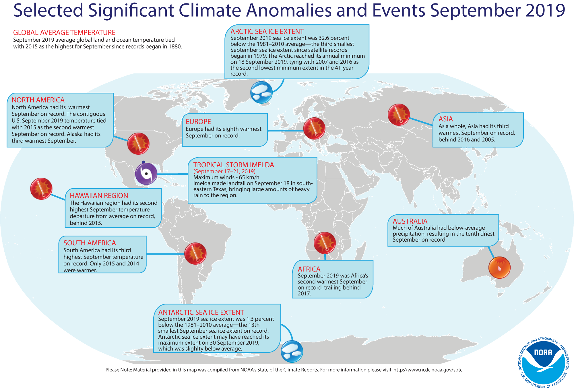
September 2019 weather and climate for the globe reviewed -- Scientists at the NOAA National Centers for Environmental Information (NCEI)
recently reported on their analysis of preliminary weather data collected from around the world during the month of September 2019. They found:
- The global combined land and ocean average surface temperature for September 2019 was 1.71 Fahrenheit degrees above the 59.0 Fahrenheit degrees, which is the 20th-century average (1901-2000) for the month. Consequently, the September 2019 global September temperature tied that for September 2015 as being the highest (warmest) September since a sufficiently dense network of global temperature records began in 1880. Furthermore, the combined land-ocean temperature across the Northern Hemisphere for September 2019 was the highest September land-ocean temperature on record, being 2.23 Fahrenheit degrees above the 20th century average and surpassing the previous record set in September 2016 by +0.05 Fahrenheit degrees.
When considered separately, the land surface temperature across the globe for this recently concluded month was the highest September temperature in the 140-year record, with a monthly temperature that was approximately 2.56 Fahrenheit degrees above the 20th-century average. The previous September record for air temperatures over land was set in September 2016, which had a temperature departure from the 20th century average of +2.48 Fahrenheit degrees Over the oceans, the September 2019 globally-averaged sea surface temperature was 1.40 Fahrenheit degrees above the 20th century average, which tied September 2016 for the second highest temperature on record for the month. The air over the oceans was the warmest in September 2015, with a record temperature departure of +1.51 Fahrenheit degrees.
- According to data provided by the National Snow and Ice Data Center (NSIDC), the September Arctic sea ice extent in the Northern Hemisphere was approximately 32.6 percent below the 1981-2010 average, which was the third smallest September Arctic sea ice extent since satellite records began in 1979. The sea ice cover reached its annual minimum extent on 18 September 2019, which tied 2007 and 2016 as the second lowest minimum extent in the 41-year period of record. In the Southern Hemisphere, the September 2019 Antarctic sea ice extent was the 13th smallest September extent on record, while the annual maximum extent may have been on 30 September 2019, with an areal coverage that was slightly below average.
- A global map of Selected Significant Climate Anomalies and Events for September 2019 is available from NCEI.
- A summary article on the September global climate highlights is available, while more detailed analysis with tables and maps can be viewed. [NOAA/NCEI State of the Climate]
Report made to Congress on recovering threatened and endangered marine species -- NOAA Fisheries recently released a 108-page document entitled "Recovering Threatening and Endangered Species FY-2017-2018 Report to Congress." This biennial report summarizes efforts made to recover all transnational and domestic species under NOAA Fisheries' jurisdiction during the fiscal years of 2017 and 2018 that run from 1 October 2016 through September 30, 2018. The report's summary table outlines the status and trend of each species that the Secretary of Commerce found would benefit from having a recovery plan, the recovery priority number, the status of the recovery plan, and the completion date for the last 5-year review. During these two fiscal years, the number of listed species under NOAA Fisheries jurisdiction has increased 10 percent, which includes 97 domestic and 66 foreign species. [NOAA Fisheries News]
West Coast fisheries are considered as "come-back of the century" -- The demand for rockfish has been reemerging along the West Coast, indicating that fish has once again become a mainstay of West Coast fisheries as stocks have been rapidly rebuilt from Washington to California. Rockfish are part of a broader category known as "groundfish," which are fish that inhabit near the bottom of the body of water. [NOAA Fisheries Feature Story]
Interactive story map shows "NOAA Supports a Healthy Nation" -- NOAA has recently unveiled a new interactive story map entitled "NOAA Supports a Healthy Nation" that demonstrates how the various agencies within NOAA have worked to increase understanding of health issues facing the public that help spark innovations to manage these risks. NOAA, with its mission "to understand and predict changes in climate, weather, oceans, and coasts", has collaborated with partner agencies, such as NASA and the Centers for Disease Control and Prevention (CDC), to make this information available to the public. Several of the recent initiatives that NOAA has been involved in are identified, accompanied by links to the story map: managing heat risks since heat is the nation's number one weather-related killer; detecting wildfire smoke and making forecasts since the smoke affects human health; detecting waterborne bacteria, especially as ocean and lake waters warm; and giving new life to endangered species in a few drought-related areas. [NOAA Story Maps]
A new index is available to help coastal managers in the Carolinas assess coastal drought -- The "Coastal Salinity Index" (CSI) was developed by collaboration between federal, state, and local interagency efforts to monitor coastal drought along the coasts of North Carolina, South Carolina, and Georgia. The commonly used drought indices that assess drought conditions in terms of hydrological, agricultural, and meteorological conditions, but do not incorporate salinity, a key stressor associated with coastal drought. Specifically, coastal drought is unique in its effects upon the salinity dynamics of rivers, and estuaries. The CSI is a standardized probability index that uses the same classification scheme as the U.S. Drought Monitor. Although this CSI was developed for the coasts of the Carolina and Georgia, it could serve as a potential blueprint for the remainder of the Eastern Seaboard, the Gulf of Mexico, and eventually, to the Pacific Coast. [USGS South Atlantic News] A two-page flier provides additional information on the CSI.
"Stormquake" seismic activity is discovered -- Researchers at Florida State University, along with colleagues from Woods Hole Oceanographic Institution, Scripps Institution of Oceanography and the U.S. Geological Survey, have discovered a geophysical phenomenon they named a "stormquake" that occurs when a massive atmospheric storm such as a tropical cyclone (hurricane) or an extratropical cyclone (a midlatitude storm such as a nor'easter) shake the seafloor so much that it rumbles like a magnitude 3.5 earthquake. These researchers analyzed seismic and oceanographic records from September 2006 to February 2019, finding a connection between strong storms and intense seismic activity near the edge of continental shelves or ocean banks. They found evidence of more than 10,000 stormquakes during this 12.5-year span offshore of New England, Florida and in the Gulf of Mexico in the United States, as well as offshore of Nova Scotia, Newfoundland and British Columbia in Canada. Apparently, the storms transfer energy into the ocean as strong ocean waves, which interact with the solid earth to produce intense seismic source activity. However, local oceanographic features and seafloor topography appear to strongly influence the production of stormquakes. [Florida State University News]
An All-Hazards Monitor-- This Web portal provides the user information from NOAA's National Weather Service, FAA and FEMA on
current environmental events that may pose as hazards such as tropical
weather, fire weather, marine weather, severe weather, drought and
floods. [NOAA/NWS Daily Briefing]
Earthweek -- Diary of the Planet [earthweek.com]
Concept of the Week: Seiche Model
A seiche (pronounced "say-sh") is a
rhythmic oscillation of water in an enclosed basin (e.g., bathtub,
lake, or reservoir) or a partially enclosed coastal inlet (e.g., bay,
harbor, or estuary). With this oscillation, the water level rises at
one end of a basin while simultaneously dropping at the other end. A
seiche episode may last from a few minutes to a few days. (Refer to
your textbook for more on seiches.)
With a typical seiche in an enclosed basin, the water level
near the center does not change at all but that is where the water
exhibits its greatest horizontal movement; this is the location of a node.
At either end of an enclosed basin, vertical motion of the water
surface is greatest (with minimal horizontal movement of water); these
are locations of antinodes. The motion of the water
surface during a seiche is somewhat like that of a seesaw: The balance
point of the seesaw does not move up or down (analogous to a node)
while people seated at either end of the seesaw move up and down
(analogous to an antinode).
The natural period of a seiche depends on the length and depth of the basin and generally ranges from minutes to hours. The period is directly proportional to basin length. For example, the natural period of a seiche in a small pond is considerably less than its period in a large coastal inlet. Also, for the same basin, the natural period is inversely proportional to water depth; that is, the period shortens as water deepens.
A 41-second mp4 video http://ametsoc.org/amsedu/ds-ocean/Seiche_Calculator.mp4 was produced providing a graphical simulation of a seiche by the University of Delaware's Seiche Calculator. The first demonstration on the video shows a case with the "Modal Number" set to 1 with a seiche in an enclosed basin. The second demonstration is for the "Modal Number" to 0.5, which would represent partially enclosed basins that usually have a node located at the mouth (rather than near the center) and an antinode at the landward end.
Historical Events:
- 21 October 1797...The USS Constitution was launched at the Charlestown Navy Yard in Boston, MA. The ship,
nicknamed "Old Ironsides," is now the oldest commissioned ship in the
U.S. Navy. (Naval Historical Center)
- 21 October 1580...Portuguese navigator Ferdinand Magellan
on his famous circumnavigation voyage of the globe reached Cape
Virgenes and the strait at the tip of South America that now bears his
name. Only three ships entered the 373-mile long passage separating
Tierra del Fuego (land of fire) and the continental mainland.
Navigating the treacherous strait in 38 days, the expedition entered
the South Pacific Ocean, which Magellan named "Mar Pacifico" for the
relatively tranquil seas that he found. However, one ship had been
wrecked and another deserted. (The History Channel)
- 21-26 October 1998...Hurricane Mitch, a category 5
hurricane (on the Saffir-Simpson Scale), developed as a tropical
depression over the southwestern Caribbean Sea about 360 mi south of
Kingston, Jamaica on the 21st. It would
intensify over the next few days to become the second deadliest
Atlantic hurricane on record, on the 24th. By
the 26th, Mitch finally dissipated after
remaining a category 5 hurricane for 33 hours. Estimated rainfall
totals of up to 75 in. caused devastating flooding and mudslides in
Honduras and Nicaragua for days. Estimated death toll from this
hurricane was more than 11,000, the worst since 1780. (The Weather
Doctor) (Accord Weather Calendar)
- 22 October 1988...A "nor'easter" swept across the coast of
New England. Winds gusted to 75 mph, and large waves and high tides
caused extensive shoreline flooding. (The National Weather Summary)
(Storm Data)
- 22 October 2005...Isla Mujeres, Mexico set the Northern Hemisphere's and Western Hemisphere's 24-hour rainfall record with 64.33 inches thanks to Hurricane Wilma. (National Weather Service files)
- 23 October 1761...A violent hurricane struck New England, causing tremendous damage in Rhode Island and Massachusetts. (National Weather Service files)
- 23-24 October 1918...The Canadian steamship Princess
Sophia carrying miners from the Yukon and Alaska became
stranded on Vanderbilt Reef along coastal British Columbia. A strong
northerly gale hampered rescue attempts, and the next day, the ship
sank with the loss of the 268 passengers and 75 crewmen onboard. (The
Weather Doctor)
- 24 October 1878: The Gale of 1878 was an intense Category 2 hurricane that was active between the 18th and 25th of October. It caused extensive damage from Cuba to New England, as was believed to be the strongest storm to hit the Washington - Baltimore region since hurricane records began in 1851. (National Weather Service records)
- 25 October 1859...The Royal Charter Storm, named after the
loss of the fully rigged ship Royal Charter off the
coast of Anglesey, England, drowned about 500 people, along with the
loss of gold bullion. The ship was one of over 200 vessels wrecked
between 21 October and 2 November, with the loss of around 800 lives.
This tragedy led to the introduction of gale warnings in England beginning in June 1860.
(The Weather Doctor)
- 25 October 1921...A hurricane made landfall at Tarpon Springs, FL, as a Category 3 (after weakening from a Category 4), causing several million dollars in damage. (National Weather Service records)
- 25 October 1941...South Greenland Patrol expanded to
include three cutters of the Northeast Greenland Patrol and form the
Greenland Patrol. (USCG Historian's Office)
- 25-26 October 1980...The combination of unusually high
tides and southeasterly winds gusting to 75 mph generated waves with
heights to 25 ft, resulting in serious flooding, beach erosion and sea
wall damage along the Maine coast. Wind damage was considerable and as
many as 100,000 homes were without power for up to 40 hrs. (Accord
Weather Guide Calendar)
- 26 October 1865...A hurricane sank the steamship USS Mobile in 1700 feet of water off the Georgia coast. The wreck, laden with 20,000 gold coins, was found in 2003. (National Weather Service records)
- 26 October 1998...Hurricane Mitch, the second deadliest hurricane in the Atlantic Ocean, reached Category 5 strength on this day. (National Weather Service records)
- 27 October 1728...Captain James Cook, the famed British
naval officer who was one of the first of the scientific navigators,
was born on this date. Captain Cook surveyed the coasts of Labrador and
Newfoundland before making three expeditions into the Pacific Ocean
where he became the first Englishman to explore previously uncharted
locations. On his various voyages, he conducted astronomical
observations and his ship's botanist studied the flora and fauna that
were collected. (Today in Science History)
- 27 October 1922...Navy Day was established by the Navy League of the United States and recognized by President Warren Harding. The day was suggested to recognize the birthdate of former President Theodore Roosevelt who had been an Assistant Secretary of the Navy and supported a strong Navy as well as the idea of Navy Day. The date was the anniversary of a 1775 report issued by a special committee of the Continental Congress favoring the purchase of merchant ships as the foundation of an American Navy. The date was last officially observed in 1949. (US Dept. of Defense)
Return to RealTime Ocean Portal
Prepared by AMS Ocean Central Staff and Edward J. Hopkins,
Ph.D.,
email hopkins@aos.wisc.edu
© Copyright, 2019, The American Meteorological Society.