Weekly Ocean News
23-27 September 2019
Items of Interest
- The Autumnal Equinox --The Autumnal
Equinox occurred early this Monday morning (officially at 0750Z on 23 September 2019 or 3:50 AM EDT or 2:50 AM CDT, etc.). At that time the noontime sun appeared directly above the equator, representing one of the two times during the year for such an occurrence, with the other being at the vernal equinox in March. The term "equinox" arises from the fact that this time of year represents "equal night" and equal day essentially everywhere. Within the subsequent several days, the length
of daylight will become noticeably shorter. This decrease in daylight will continue for another three months to the winter solstice during the evening of Saturday, 21 December 2019.
Editor's note: John White, a meteorologist from
North Carolina involved with the AMS Education program, reported that
the geosynchronous (or geostationary) satellites make an "satellite
eclipse" of the sun near the spring and autumnal equinoxes because of
their equatorial orbit, such that these satellites pass through the
earth's shadow and the satellite is powered down when the solar array
does not receive sufficient sunlight. EJH.
If you check the sunrise and sunset times in your local newspaper or from the climate page at your local National Weather Service Office, you would probably find that later this week the length of time when the Sun is above the local horizon would be precisely 12 hours at most locations. By the end of this week, the length of night will finally exceed that of the length of daylight. The effects of atmospheric refraction (bending of light rays by the varying density of the atmosphere) along with a relatively large diameter of the sun contribute to several additional minutes that the Sun appears above the horizon at sunrise and sunset.
- Worldwide GLOBE at Night 2019 Campaign for late September is underway -- The tenth in a series of GLOBE at Night citizen-science campaigns for 2019 will continue through Sunday, 29 September. GLOBE at Night is a worldwide, hands-on science and education program designed to encourage citizen-scientists worldwide to record the brightness of their night sky by matching the appearance of constellations with the seven magnitude/star charts of progressively fainter stars. These constellations are Cygnus in the Northern Hemisphere and Sagittarius in the Southern Hemisphere. Activity guides are also available. The GLOBE at night program is intended to raise public awareness of the impact of light pollution. The eleventh series in the 2019 campaign is scheduled for 19-28 October 2019. [GLOBE at Night]
- September is National Preparedness Month -- The month of September has been declared National Preparedness Month (NPM), which is aims to educate and empower Americans to prepare for and respond to all types of emergencies, including natural disasters. NPM is managed and sponsored by the Federal Emergency Management Administration's (FEMA) Ready Campaign in conjunction with the Ad Council, A toolkit of marketing materials is provided to help promote the month and represents the lead on this campaign that was originally launched in 2004. The overarching theme for 2019 NPM is "Prepared, Not Scared" with an emphasis on preparedness for youth, older adults, and people with disabilities and others with access and functional needs.
Week 4 of the 2019 NPM runs this week (22-30 September) with the theme of "Get Involved in Your Community's Preparedness."
[FEMA's Ready.gov]
- Watching for high ocean tides along nation's coasts late this week -- According to the NOAA National Ocean Service's High Tide Bulletin for Fall 2019, higher than average astronomical tides are expected late this week, beginning on 25 September 2019 and running through 2 October along sections of the nation's coasts. The high tides will be found along the coasts of Alaska, the Hawaiian Islands and the entire U.S. Atlantic Coast, running from Florida's Atlantic coast northward to Maine. Lunar perigee (when the Moon is closest to Earth) will occur on Friday evening (27 September), followed nearly 16 hours later by the new moon (when the Moon is between Earth and the Sun). These two astronomical events will be responsible for the perigean spring tide that creates higher than normal high tides. Furthermore, mean sea level is generally higher in the early fall months in the along the Atlantic Coast due to warmer, expanding ocean water and changes in weather patterns. [NOAA National Ocean Service News]
- Investigating NOAA's "Global Climate Dashboard" -- A member of the staff at NOAA's Climate Program Office wrote a feature that helps the user navigate the NOAA "Global Climate Dashboard." This web-based app provides one-stop access to information, maps, and graphs of key indicators of the global climate. Interactive graphs deliver a system-wide view of the state of natural patterns like El Niño and the Arctic Oscillation and those linked to human-caused climate change, such as sea level rise and increases in greenhouse gases. [NOAA Climate.gov News]
- World Environmental Health Day to focus on air quality -- This Thursday (26 September 2019) has been declared World Environmental Health Day by the International Federation of Environmental Health. This event is celebrated each year. The theme for the 2019 World Environmental Health Day is "Climate change challenges, time for global Environmental Health to act in unison," which is intended call for environmental health practitioners around the world to play a pivotal role in adaptation strategies and measures to protect especially vulnerable communities against the challenges of climate variability at a grassroots level. [International Federation of Environmental Health]
- Reconstructing past oceanic conditions from marine
sediment cores -- If you would like information on how
scientists can reconstruct past environmental conditions in the oceans
from the analysis of the physical, chemical and geological data in
deep-sea sediment cores, please read this week's Supplemental
Information...In Greater Depth.
Ocean in the News
- https://en.wikipedia.org/wiki/Tropical_cyclone_basins
- http://weather.unisys.com/hurricanes/search
- https://en.wikipedia.org/wiki/2019_Atlantic_hurricane_season
- https://en.wikipedia.org/wiki/2019_Pacific_hurricane_season
- https://en.wikipedia.org/wiki/2019_Pacific_typhoon_season
- https://en.wikipedia.org/wiki/2019_North_Indian_Ocean_cyclone_season
- https://en.wikipedia.org/wiki/2018%E2%80%9319_South-West_Indian_Ocean_cyclone_season
- https://en.wikipedia.org/wiki/2018%E2%80%9319_South_Pacific_cyclone_season
- https://en.wikipedia.org/wiki/2018%E2%80%9319_Australian_region_cyclone_season
- http://www.bom.gov.au/cyclone/
- http://www.metoc.navy.mil/jtwc/jtwc.html
- https://www.nhc.noaa.gov/
FROM LAST WEEK ==>- Eye on the tropics -- Tropical cyclone activity continued in the Atlantic, Pacific and Indian Ocean basins of the Northern Hemisphere during the last week:
- In the North Atlantic basin (that includes the open North Atlantic, along with the Caribbean Sea and the Gulf of Mexico) --
- Hurricane Humberto, located approximately 760 miles to the west of Bermuda at the start of last week, was heading to the northeast. At the time, Humberto was a category 1 on the Saffir-Simpson Scale. By Tuesday morning, Humberto had strengthened to a category 2 hurricane and then strengthened to a major category 3 hurricane as of Tuesday evening as it traveled toward the east-northeast. This category 3 hurricane became the second major hurricane (category 3 or greater) of the 2019 Atlantic season. The central eye of Hurricane Humberto passed approximately 75 miles to the north of Bermuda on Wednesday evening. However, the island was raked by hurricane force winds. On early Thursday morning, Humberto reached peak intensity as maximum sustained surface winds reached 125 mph. Humberto began weakening as it curved toward the northeast during Thursday afternoon as it headed across cooler North Atlantic waters. As of late Thursday night, Humberto lost its tropical characteristics and became a powerful extratropical cyclone (midlatitude storm) as it was traveling toward the north-northeast approximately 525 miles to the south-southwest of Cape Race, Newfoundland. At that time, maximum sustained surface winds were 100 mph. Consult the NASA Hurricane Blog for additional information and satellite imagery on Tropical Storm Humberto.
- A tropical depression developed late last Tuesday morning just off the Texas Gulf Coast, approximately 55 miles to the south-southwest of Galveston, TX. By early afternoon, this tropical depression strengthened to become Tropical Storm Imelda with maximum sustained surface winds measured to be 40 mph as the system was passing close to a National Ocean
Service observing site at Freeport, TX. Within one hour, Tropical Storm Imelda had made landfall near Freeport, which is 35 miles to the south of Galveston. Moving onshore along the Texas Gulf Coast, Imelda weakened and was downgraded to Tropical Depression Imelda by Tuesday evening as it was to the north of Houston, TX. Over the course of the next two days, Imelda continued northward, before becoming a weak atmospheric disturbance (identified as an open wave) late Thursday afternoon approximately 130 miles to the north-northwest of Houston. However, the torrential rain accompanying the slow-moving Imelda brought catastrophic flooding to the Houston metropolitan area. More than 40 inches of rain fell in some areas. According to some reports, Tropical Storm Imelda has been declared to be the fifth-wettest tropical cyclone to strike the continental United States. Additional information and a satellite image for Tropical Storm Imelda are available on the NASA Hurricane Blog
Editor's Note: The title should read Imelda - Gulf of Mexico EJH
- The tenth tropical depression of the 2019 Atlantic hurricane season developed last Tuesday over the central tropical Atlantic, approximately 1165 miles to the east-southeast of the Leeward Islands. On Wednesday morning, this tropical depression, which was moving toward the west-northwest, strengthened to become Tropical Storm Jerry. Slightly more than one day later, U.S. Air Force aircraft determined that Jerry had intensified to become a category 1 hurricane, as maximum sustained surface winds were determined to have reached 75 mph. At that time, Hurricane Jerry, which is the fourth Atlantic hurricane of 2019, was located approximately 490 miles to the east of the Leeward Islands. Approximately 12 hours later on Thursday afternoon, Jerry had become a category 2 hurricane with sustained winds of 105 mph. Traveling toward the west-northwest on Friday, Jerry began weakening as it passed to the north of the northern Leeward Islands. It weakened to a tropical storm early Saturday morning as it passed to less than 300 miles to the north of the U.S. Virgin Islands and Puerto Rico. Tropical Storm Jerry began curving toward the northwest late Saturday and then toward the north-northwest on Sunday morning. As of late Sunday night, Tropical Storm Jerry was heading toward the northwest, approximately 370 miles to the south-southwest of Bermuda. Jerry was forecast to continue to travel toward the north-northwest on Monday followed by a turn toward the north on Monday night and then to the northeast on Tuesday. The projected track of Tropical Storm Jerry would take it close to Bermuda by Tuesday night. General weakening was anticipated over the early part of the week. The NASA Hurricane Blog has satellite images and additional information on Hurricane Jerry.
- On Sunday morning, Tropical Storm Karen formed approximately 100 miles to the east of Grenada in the Windward Islands. Traveling to the west-northwest, Karen passed just to the north of Tabago later in the morning.
On Sunday night, Karen was moving across the southeastern Caribbean, as it was located approximately 140 miles to the west-northwest of Grenada. Forecasts indicate that Karen should curve toward the northwest on Monday, with little change in intensity.
- In the eastern North Pacific basin (located off the western North American continent and extending westward to the 140-degrease West meridian) --
- Hurricane Kiko, which had been a major category 4 hurricane (on the Saffir-Simpson Scale) earlier last weekend, was beginning to weaken last Monday as it was heading westward away from the coast of Mexico. As of Monday morning, Kiko was nearly 1000 miles to the west-southwest of Cabo San Lucas, located at the southern tip of Mexico's Baja California Peninsula. Movement was to the west-northwest. Kiko began a slow weakening trend that resulted in it being downgraded to a tropical storm on Tuesday morning. For the next three days, Tropical Storm Kiko headed generally toward the west with some changes in intensity. By Saturday afternoon, Kiko had weakened to a minimal tropical storm. As of Sunday evening, Tropical Storm Kiko was approximately 1680 miles to the west-southwest of Cabo San Lucas, Mexico. Kiko was forecast to begin curving toward the northwest by Tuesday, accompanied by some re-strengthening. The NASA Hurricane Blog has satellite images and additional information on Hurricane Kiko.
- Tropical Storm Lorena formed last Tuesday morning off the southwestern Mexican coast, approximately 300 miles to the south-southeast of Zihuatanejo, Mexico. Traveling toward the northwest, Lorena intensified to become a hurricane on Wednesday night just off the coast of the Mexican state of Colima. or approximately 35 miles to the southwest of Manzanillo, Mexico. Hurricane Lorena hugged the Mexican coast on Thursday as it traveled toward the north-northwest. Lorena weakened to a tropical storm on Thursday evening, but re-intensifed to a hurricane in the predawn hours of Friday as it was approximately 100 miles to the east-southeast of Cabo San Lucas, Mexico. By Friday afternoon, the eye of Hurricane Lorena was hugging the southern portion of the Baja California Peninsula. The center of Lorena made landfall as a category 1 hurricane near La Ventana, Mexico in southeastern Baja California Sur late Friday night. After making a brief landfall along the southeastern coast of the Baja, Lorena moved out over the Gulf of California and headed northward. However, the central core of Hurricane Lorena did not survive the interaction with the high terrain of the southern Baja California, and it headed for the northwestern coast of mainland Mexico as a tropical storm on Saturday. Crossing the Gulf of California, Lorena weakened to a tropical depression as it approached the coast of western mainland Mexico near Guaymas early Sunday morning. By midmorning on Sunday, Lorena had become a broad low pressure area after making landfall along the coast of northwestern Mexico. The NASA Hurricane Blog has additional information on Hurricane Lorena.
- At approximately the same time that Tropical Storm Lorena formed last Tuesday morning, the fourteenth tropical depression of 2019 in the eastern Pacific formed approximately 770 miles to the south of Cabo San Lucas, Mexico. By Tuesday afternoon, this system became Tropical Storm Mario as it headed toward the northwest. Over the next three days, Mario strengthened, but then became slightly disorganized as it continued slowly toward the northwest, the north and the north-northeast. As of early Sunday morning, Mario became a tropical depression. Tropical Depression Mario was located approximately 160 miles to the south of Cabo San Lazaro, Mexico on Sunday night. This system was forecast to become a remnant low on Monday and it should move over the central portion of the Baja California Peninsula on Monday night and Tuesday. Consult the NASA Hurricane Blog for more information on Tropical Storm Lorena.
- In the western North Pacific basin (extending from the International Dateline westward to the Asian continent) --
- Tropical Depression Peipah was traveling toward Iwo To (Iwo Jima) at the beginning of last week. However, Peipah encountered strong wind shear (changes in wind speed and/or direction over a given distance), causing it to become a remnant low. Additional information on Tropical Depression Peipah can be found on the NASA Hurricane Blog.
- A tropical depression formed early last week to the east of Batanes, an archipelago that is a Philippine province located north of Luzon Island. Traveling northward, this tropical depression strengthened to become Tropical Storm Tapah over the East China Sea. By the end of the week, it had intensified to become a typhoon by the time it approached the vicinity of Okinawa, Japan. Strong winds, heavy rain and high waves accompanying Typhoon Tapah caused at least 20 injuries over this past weekend in southern Japan. By late in the weekend, Tapah had weakened to a tropical storm. As of early Monday, Tropical Storm Tapah was located approximately 80 miles to the north-northwest of Iwakuni, on the southern coast of Japan's Honshu Island. Tapaha was expected to loose its tropical characteristics on Monday as it continues to move to the northeast across the Sea of Japan. Consult the NASA Hurricane Blog for additional information and satellite imagery on Typhoon Tapaha.
- In the North Indian Ocean basin --
A tropical cyclone formed over the waters of the Arabian Sea off the west coast of India on Sunday. This system was identified as Tropical Cyclone 3A as it was the third tropical cyclone in the Arabian Sea sector of the North Indian Ocean. As on Monday, TC-3A was located 300 miles to the south of Karachi, Pakistan. This tropical storm was moving toward the west and was expected to strengthen slightly as it takes a track to the west-southwest toward the coast of Somalia during the first half of this current week.
- A record -- This past Wednesday (18 September) six named tropical cyclones were reported in the North Atlantic and eastern North Pacific Basins: Humberto, Jerry, and Imelda in the Atlantic Basin and Kiko, Mario and Lorena in the eastern Pacific Basin. Staff from the National Hurricane Center tweeted NOAA’s National Hurricane Center reported that this combined number of six active storms in both basins was believed to have tied a modern record previously set in September 1992.
[WeatherUnderground]
Exploring the seafloor of the National Marine Sanctuary of American Samoa -- A science communication fellow wrote an article about her experiences onboard the Exploration Vehicle (E/V) Nautilus as it made its first expedition to the NOAA’s National Marine Sanctuary of American Samoa, the largest sanctuary in U.S. waters. E/V Nautilus is a 211-foot research vessel owned by the Ocean Exploration Trust under the direction of the famous deep-sea explorer, Dr. Robert Ballard. Two connected remotely operated vehicles, Argus and Hercules were employed to explore the deep ocean to the sea floor, which was at a depth of over 9800 feet. [NOAA National Marine Sanctuaries News]
Federal funding awards used to support U.S. aquaculture -- The National Sea Grant College Program recently announced that $16 million in federal funding awards has been made available to support 42 research projects and collaborative programs aimed at advancing sustainable aquaculture across the nation. The funded projects focus upon three areas of need identified by Sea Grant: Advanced Aquaculture Collaborative Programs (10 projects); Exploring New Aquaculture Opportunities (16 projects); and Social, Economic, and Behavioral Research Needs in Aquaculture (16 projects). [NOAA Sea Grant News]
"Ocean Observing Prize" competition announced to power ocean-observing platform with renewable energy -- During the last week, NOAA and the U.S. Department of Energy, announced a $3 million prize competition called the "Ocean Observing Prize" that is intended to generate innovation in marine renewable energy-powered ocean observing platforms. Two separate competitions are involved, with prize awards during each phase. The first competition will solicit novel concepts that pair ocean observing technologies with marine energy systems to address five themes: charging unmanned systems; communications and underwater navigation; extreme environments; buoys, floats, and tags; and innovative ideas. The prize will then have a second follow-on phase with competitions to bring innovators' ideas to reality.[NOAA News]
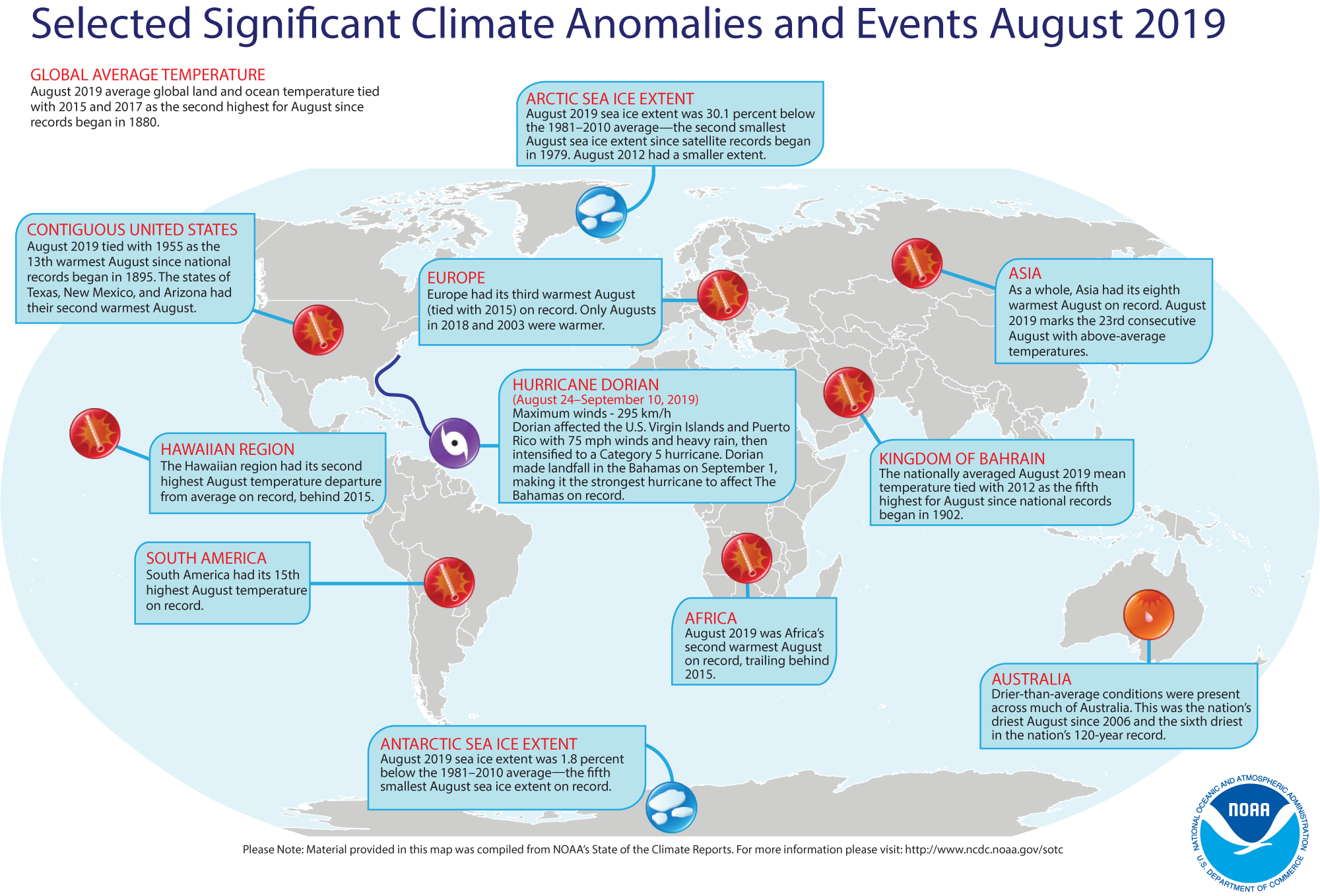
Review of August 2019 (and seasonal) weather and climate for the globe -- Preliminary data analyzed by scientists at
NOAA's National Centers for Environmental Information (NCEI) indicated:
- The global combined land and ocean average surface temperature for August 2019 was 1.66 Fahrenheit degrees above the 20th-century average (1901-2000) for
the month, tying last month with August in 2015 and 2017 for the second warmest August since a sufficiently dense network of global temperature records began in 1880. The warmest August on record was August 2016, which was 1.76 Fahrenheit degrees above the 1901-2000 average. When considered separately, the land surface temperature for this recently concluded month was the fourth highest August temperature in the 140-year record, with a monthly temperature that was approximately 2.05 Fahrenheit degrees above the 20th-century average. The August 2019 monthly temperature departure of the ocean surface was 1.51 Fahrenheit degrees above the 20th-century average, which was the highest August temperature on record, even though ENSO-neutral conditions prevailed during August 2019. Furthermore, this monthly global ocean surface temperature tied the reading for September 2015 for being the sixth highest monthly temperature departure from all 1676 months of the record that began in 1880.
NOTE: Climate scientists prefer to generate long-time series of global temperatures using temperature anomalies (or the arithmetic differences between the observed monthly temperatures and the corresponding long-term 20th century averages), as a better means for gathering information in data-sparse areas or where missing station data present a problem. [NOAA Climate.gov News]
- A global map of Selected Significant Climate Anomalies and Events for August 2019 is available from NCEI.
- During the last three months, which constitutes meteorological summer in the Northern Hemisphere and meteorological winter in the Southern Hemisphere, the
combined global land and ocean average temperature for June-August 2019 was 1.67 Fahrenheit degrees above the 20th-century average, which was the second highest temperature departure for this three-month period since 1880. Only the June-August temperature anomaly for the globe in 2016 was greater. The June-August 2019 average ocean temperature tied the corresponding months in 2016 as being the highest on record. The three-month temperature for the global land surface was the third highest for any boreal summer in the last 140 years. The combined ocean-land surface temperature for the Northern Hemisphere for boreal summer tied the summer 2016 for the highest in the 140-year period of record.
- According to data provided by the National Snow and Ice Data Center (NSIDC), the average August Arctic sea ice extent in the Northern Hemisphere was approximately 30 percent below the 1981–2010 average, making it the second smallest August Arctic sea ice extent since satellite records began in 1979. In the Southern Hemisphere, the August 2019 Antarctic sea ice extent was the fifth smallest August extent in the 41-year period of record.
[NOAA/NCDC
State of the Climate]
An All-Hazards Monitor-- This Web portal provides the user information from NOAA's National Weather Service, FAA and FEMA on
current environmental events that may pose as hazards such as tropical
weather, fire weather, marine weather, severe weather, drought and
floods. [NOAA/NWS Daily Briefing]
Earthweek -- Diary of the Planet [earthweek.com]
Concept of the Week: Variations in Marine
Sediment Thickness
Sediments are particles of organic or
inorganic origin that accumulate in loose form in depositional
environments such as lake or ocean bottoms. Marine sediments, the
central focus of this week's investigations, have a variety of sources
and exhibit a wide range of composition, size, and shape. Marine
sediments settle to the ocean floor as unconsolidated accumulations but
ultimately may be converted to solid sedimentary rock via compaction
and cementation. The pattern of variations in marine sediment thickness
on the ocean floor confirms some basic understandings regarding marine
geological processes.
Go to the RealTime Ocean Portal and
under "Geological," click on "Sediment Thickness." This map of marine
sediment thickness in the ocean basins was compiled by the National
Geophysical Data Center (NGDC), Marine Geology and Geophysics Division
primarily based on existing maps, ocean drilling, and seismic
reflection profiles. Sediment thickness is color-coded in meters from
violet (thinnest) to red (thickest). Many factors account for the
variation in the thickness of marine sediment deposits including type
and location of sediment sources, sediment transport mechanisms, and
the age of the underlying crust.
According to the map, sediment thickness generally increases
with distance from near the central portion of an ocean basin to the
continental margin. This pattern may be explained by the principal
sediment source and/or the age of the underlying crust. Rivers and
streams that empty into the ocean slow and diverge, releasing the bulk
of their suspended sediment load in coastal environments (e.g., bays,
estuaries, deltas) and onto the continental shelf. Ocean currents
transport sediment along the coast. In some areas of the continental
shelf, massive amounts of sediment accumulate, become unstable, and
flow down the continental slope to the base of the continental rise and
beyond. However, only the finer fraction of river-borne sediment is
swept into the deep ocean waters. Thickening of marine sediments in the
direction of the continental margin may also reflect the aging of
oceanic crust with distance away from divergent (spreading) plate
boundaries where new oceanic crust forms. The older the crust the
longer is the period that sediment rains down on the ocean bottom and
the thicker is the blanket of accumulated sediment.
The map indicates that the thickness of marine sediment
deposits is greater in the continental margin along the Atlantic coast
of North America than along the Pacific coast. The Atlantic coast of
North America is a passive margin; that is, the
continental margin is not affected significantly by tectonic processes
(no plate boundary) and the principal geological processes consist of
sedimentation along with erosion by ocean waves and currents. In fact,
passive margins and relatively thick marine sediment deposits occur on
both sides of the Atlantic. (Passive margins also occur around the
Arctic Ocean and surrounding Antarctica.) On the other hand, the
Pacific coast of North America is an active margin;
that is, the continental margin is associated with plate boundaries and
is subject to deformation by tectonic stresses. Active continental
margins are relatively narrow so that sediment delivered to the coast
by rivers and streams flows directly into deeper water or
trenches--preventing thick accumulations of marine sediments from
building in the continental margin.
Historical Events
- 23 September 1551...The Grand Harbour at Valetta, Malta was
hit by a waterspout that then moved inland and caused extensive damage.
A shipping armada in the harbor about to go into battle was destroyed
by the waterspout killing at least 600 people. (The Weather Doctor)
- 23 September 1815...One of the most powerful hurricanes to
strike New England made landfall initially on Long Island, NY and then
again at Old Saybrook, CT before crossing into Massachusetts and New
Hampshire. Extensive structural damage resulted. Providence, RI was
flooded and six people were killed. This "Great September Gale" was the
worst tempest in nearly 200 years, equal in strength to the Great 1938
Hurricane, and one of a series of severe summer and autumn storms to
affect shipping lanes that year. (David Ludlum)
- 24 September 1493...Christopher Columbus set sail with 17
ships on his second expedition to the New World, reaching the Lesser
Antilles, the Virgin Islands, Puerto Rico and Hispaniola before
returning to Europe in March 1496. (Wikipedia)
- 25 September 1513...Vasco Núñez de Balboa, a Spanish
conquistador-explorer, crossed the isthmus of Panama and reached the
Pacific Ocean, which he christened Mar del Sur (South Sea), claiming
the ocean and all adjacent lands for Spain. (Wikipedia)
- 25 September 1939...A West Coast hurricane moved onshore
south of Los Angeles bringing unprecedented rains along the southern
coast of California. Nearly 5.5 in. of rain drenched Los Angeles during
a 24-hr period. The hurricane caused $2 million in damage, mostly to
structures along the coast and to crops, and claimed 45 lives at sea.
"El Cordonazo" ("the lash" or "whip") produced 5.66 in. of rain at Los Angeles and 11.6 in. of
rain at Mount Wilson, both records for the month of September. It was the only time in the 20th Century that the center of a tropical storm made landfall still at tropical storm strength on the California coast. (David
Ludlum) (The Weather Channel) (National Weather Service files)
- 25 September 1956...The world's first transatlantic
telephone cable system began operating (Clarenville, Newfoundland to
Oban, Scotland). Previous cables had been limited to telegraph
transmissions. (Today in Science History)
- 26 September 1580...English seaman Francis Drake returned
to Plymouth, England, in the Golden Hind, becoming
the first British navigator to circumnavigate the globe. He had
commenced his voyage around the world on 13 December 1577 with five
ships, but returned with only one ship. During his voyage in the
Pacific Ocean, he paused near San Francisco Bay and then traveled as
far north as present-day Washington State. He brought back valuable
information about the world's ocean to Queen Elizabeth I. (The History
Channel)
- 26-27 September 1959...Typhoon Vera ravaged Honshu, Japan,
the nation's largest island, leaving over 5000 dead, more than 40,000
injured, 1.5 million homeless and 40,000 homes destroyed. It was
Japan's greatest storm disaster to that date. (The Weather Doctor)
- 27 September 1854...After colliding with the French ship SS Vesta in dense fog, the American Collins Line
steamship Arctic sank with more than 300 people on
board near Cape Race, Newfoundland, marking the first great disaster in
the Atlantic Ocean. (Wikipedia)
- 27 September 1922...Report on observations of experiments
with short wave radio at the Naval Aircraft Radio Laboratory in
Anacostia, DC started US Navy development of radar. (Navy Historical
Center)
- 27 September 1958...A typhoon caused the death of nearly
5000 people on Honshu, the main Japanese island. (Wikipedia)
- 28 September 1542...Portuguese explorer Juan Rodríguez
Cabrillo sailed into present-day San Diego (CA) Bay during the course
of his explorations of the northwest shores of Mexico on behalf of
Spain. His landing at Point Loma Head apparently was the first known
European encounter with California. Before dying on the Channel Islands
off the Santa Barbara coast in January 1543, he had explored much of
the California coast. (The History Channel)
- 28 September 1850...An Act of Congress (9 Stat. L., 500,
504) provided for the systematic coloring and numbering of all buoys
for, prior to this time, they had been painted red, white, or black,
without any special system. The act "prescribed that buoys should be
colored and numbered so that in entering from seaward red buoys with
even numbers should be on the starboard or right hand side; black buoys
with odd numbers on the port or left hand side; buoys with red and
black horizontal stripes should indicate shoals with channel on either
side; and buoys in channel ways should be colored with black and white
perpendicular stripes." (US Coast Guard Historians Office)
- 28 September 1994...The auto ferry Estonia capsized and sank quickly in rough waters in the Baltic Sea. It was reported that there were at least 6-foot waves in the area. About 900 people lost their lives, while there were 141 survivors.
- 29 September 1959...Hurricane Gracie made landfall near
Beaufort, SC with sustained winds of 97 mph and a peak gust of 138 mph.
Ten people were killed in South Carolina and Georgia. As the weakening
storm moved through Virginia on the 30th, the storm spawned an F3
tornado at Ivy, VA, which killed 11 people. On the same day, a storm
produced 28 inches of snow in Colorado Springs, CO. (David Ludlum)
Return to RealTime Ocean Portal
Prepared by AMS Ocean Central Staff and Edward J. Hopkins,
Ph.D.,
email hopkins@aos.wisc.edu
© Copyright, 2019, The American Meteorological Society.