WEEKLY CLIMATE NEWS
22-26 July 2013
DataStreme Earth Climate Systems will return for Fall 2013 with new Investigations files starting during Preview Week, Monday, 2 September 2013. All the current online website products will continue to be available throughout the summer break period.
ITEMS
OF INTEREST
- Peak in the annual temperature curves -- This upcoming week is the fourth full week of July, which for many locations across the nation typically marks the warmest week of the year, as indicated by the daily normal high and low temperatures. Usually, those stations located away from the moderating influences of the oceans reach their highest temperatures during the third to fourth week of July, or a roughly one month after the summer solstice, when the Northern Hemisphere receives the most hours of daylight and the largest amounts of solar radiation. During July, temperatures continue to rise to their highest typical values as radiational heating continues. However, the length of daylight and the amount of sunshine during this month begin decrease and the normal daily temperatures will begin to fall toward their lowest levels in mid to late January.
- Zenithal Sun -- Residents of Hawaii's Big Island will experience a noontime sun that would be directly overhead during this week (22-23 Jul). This occurrence of a zenithal sun is one of the two times during the year when the noontime sun is directly overhead to residents of Hilo and elsewhere on the Big Island. The other time when the Big Island experienced a zenithal sun was in mid May [US Naval Observatory, Data Services]
- AMS Space Weather Policy Statement unveiled -- Earlier this month, the AMS (American Meteorological Society) Council approved the "Space Weather Policy Statement" that provides a definition of "space weather," identifies the social impacts of space weather, discusses the efforts involved with predicting it and provides recommendations involving space weather research and services. [Anmerican Meteorological Society]
- NASA's Student Airborne Research Program provide a great learning experience -- A group of 32 college students from around the United States are spending eight weeks this summer participating in NASA's 2013 Student Airborne Research Program (SARP) that offer hands-on experience in the planning and execution of a NASA Airborne Science mission. These student interns were involved in every aspect of a science mission from upload of sensors to collecting science data, in the air, on the ground or from a boat. After their field experience, the undergraduate interns began classroom and laboratory work at the University of California, Irvine where they are poring over the science data and developing presentations to summarize their research. [NASA Dryden Flight Research Center]
CURRENT
CLIMATE STATUS
- June 2013 weather and climate for the nation and globe reviewed -- Scientists at the NOAA National Climatic Data Center
recently reported on their analysis of preliminary weather data collected during the month of June 2013:
- National weather and climate -- When averaged across the coterminous United States, the monthly temperature for June 2013 was 70.4 degrees Fahrenheit, which was 2.0 Fahrenheit degrees above the 20th-century
(1901-2000) average. Consequently, this past June was the 15th warmest June since 1895 when comprehensive climate records became available nationwide. Most of the states across the West had above to much above average temperatures. Six Southwestern states (California, Nevada, Utah, Colorado, New Mexico and Arizona) reported statewide June temperatures that were in the top 10 highest June temperatures on record. Several New England and Middle Atlantic States also reported above average temperatures. No state reported a significantly below average June temperature.
The nationwide average precipitation for June 2013 was 3.42 inches, which was 0.54 inches above the 20th-century average, making that month the 13th wettest June in 119 years. Nearly all states east of the Mississippi River had much above average June precipitation. Eighteen states along the Atlantic Seaboard and Appalachians had statewide June precipitation totals that were in the top 10 wettest. Delaware and New Jersey reported their wettest June since 1895. On the other hand, eight states across the southern Rockies and the Great Basin recorded below to much below average June precipitation totals. Utah experienced its driest June in 119 years, while Arizona, Colorado and Wyoming had monthly precipitation totals that ranked within the top 10 driest.
[NOAA
National Climatic Data Center]
- June national drought report -- The National Climate Data Center has posted its June 2013 drought report online. Using the Palmer Drought Severity Index, approximately 29 percent of the coterminous United States experienced severe to extreme drought conditions at the end of June, while 12 percent of the area had severely to extremely wet conditions.
- Global temperatures and ice cover -- The combined global land and ocean surface temperature for June
2013 was 61.5 degrees Fahrenheit, which tied the temperature for June 2006 as the fifth highest for any month of June since sufficiently detailed global climate records
began in 1880. The global temperature for June 2013 was 1.15 Fahrenheit degrees above the 20th
century (1901-2000) average. The scientists noted that June 2013 was the 340th consecutive month in which the global temperature was above the 20th century average; the last below-average temperature for any month was February 1985. When considered separately,
the average land temperature was the third highest for any June since
1880, while the temperature over the oceans was the tenth highest for
any June. Sea-surface temperatures across the eastern half of the
equatorial Pacific Ocean were slightly below average in June due to ENSO-neutral conditions (ENSO = El Niño/Southern Oscillation).
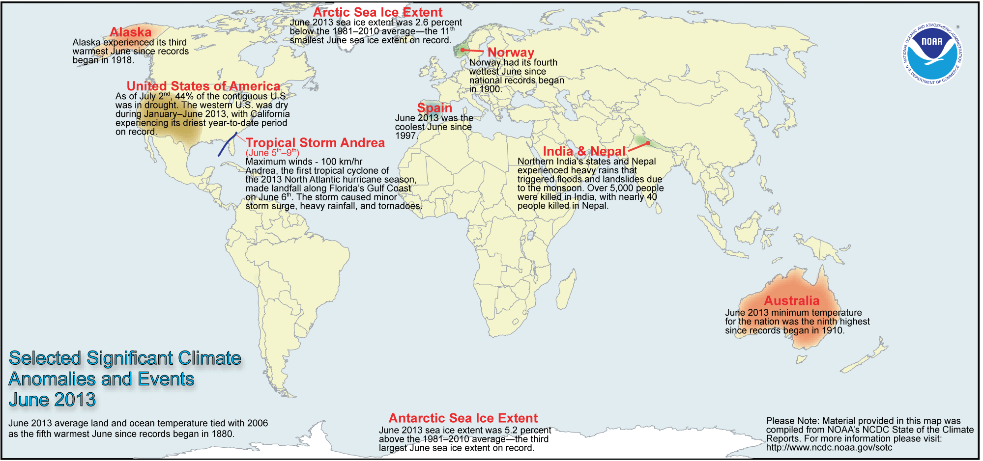
The researchers at the National Snow and Ice Data Center noted the areal extent of the Arctic sea ice
for June 2013 was
the eleventh smallest since satellite surveillance began in 1979. On the
other hand, the extent of the Antarctic sea ice was the third largest
in the 35-year record. [NOAA/NCDC
State of the Climate] [NOAA
Environmental Visualization Laboratory] A global map of Selected Significant Climate Anomalies and Events for March 2013 is available from NCDC.
- Extent of July 2013 heat wave across nation is displayed -- A map was generated from data obtained from NOAA's Real-Time Mesoscale Analysis that shows the maximum air temperatures across the coterminous United States during the exceptional heat wave that extended between 10 and 19 July 2013. [NOAA Environmental Visualization Laboratory]
- Number of nighttime heat waves in Pacific Northwest quadruple -- Members of the Office of the Washington State Climatologist at the University of Washington and the Oregon Climate Service have found that the frequency of nighttime heat waves in sections of Washington and Oregon west of the Cascades between 1981 and 2010 has quadrupled over the number between 1901 and 1980. The researchers defined a nighttime heat wave as being a stretch of at least three nights in a row where the daily low temperature is in the top 1 percent of the temperatures on record. For Seattle, the minimum temperature should be above approximately 61.5 degrees Fahrenheit. The researchers also noted a 50 percent increase in the number of regional hospitalizations as being related to heat on dates identified as heat waves. [University of Washington News]
CURRENT
CLIMATE MONITORING
- Next generation geosynchronous satellite to provide continuous full-disk imagery -- Engineers and scientists involved with the planning and development of NOAA's next generation of geosynchronous environmental satellites that will begin with GOES-R report that these satellites will have the ability to obtain data at a rate capable of producing full-disk images of Earth at five-minute intervals. Current GOES satellites make a full disk scan in approximately 30 minutes. Increased imagery over a shorter time span and at higher resolution will provide more timely and informative data to forecasters everywhere in the Western Hemisphere. [NASA GOES Project]
- An All-Hazards
Monitor -- This Web portal provides the user information from NOAA on
current environmental events that may pose as hazards such as tropical
weather, fire weather, marine weather, severe weather, drought and
floods. [NOAAWatch]
CLIMATE IMPACTS ON THE BIOSPHERE
- Increased atmospheric carbon dioxide levels alter water use by plants Scientists affiliated with the National Science Foundation's (NSF) Harvard Forest Long-Term Ecological Research (LTER) site in north-central Massachusetts recently reported that forests in the northeastern United States and elsewhere across the globe are losing less water than expected and becoming even more efficient at using it for growth as atmospheric carbon dioxide levels rose. Apparently with increased carbon dioxide available for photosynthesis, the stomata in the tree leaves do not need to open as wide or as long so the plants lose less water and grow faster. [NSF News]
CLIMATE FORCING
- "Supraglacial" lake drainage studied -- Researchers from The City College of New York (CCNY), Los Alamos National Laboratory and the United Kingdom's University of Cambridge have been studying the drainage from "supraglacial" lakes, which are bodies of liquid water that collect on the surface of the Greenland ice sheet, using data collected from five GPS (Global Positioning System) stations surrounding two such lakes. They found differences in how the lakes drain from the surface to the beneath the glacier can affect glacial movement because the amount of drainage lubricates the bottom of the ice sheet when they drain, causing the ice to flow faster. Knowledge of the draining could help in understanding how surface melting of the ice could impact sea-level rise. [The City College of New York News]
- Inland tropical cyclones can be fueled by a "brown ocean" -- Researchers at University of Georgia claim that some tropical cyclones can intensify even after making landfall provided that the ground over which the storm travels is sufficiently wet to continue providing the evaporative heating that it received when it was over the ocean. The saturated ground that provided the necessary water vapor could be considered to be a "brown ocean." The scientists found that of the 3254 tropical cyclones that formed globally between 1979 and 2008, as many as 227 tropical cyclones could be considered "inland tropical cyclones," with 45 of these systems maintaining or increasing in strength after landfall. [NASA's Earth Science News Team]
CLIMATE FORECASTS
- New Seasonal Climate Outlooks for late summer/early fall issued -- Near the end of last week, forecasters at the NOAA Climate Prediction Center (CPC) released their new national Three-Month (Seasonal) Climate Outlooks for August through October 2013, corresponding to the last month of the meteorological summer season (in the Northern Hemisphere) and the first two months of meteorological autumn. Specific details of their outlooks include:
- Temperature and precipitation outlooks -- According to their temperature outlook, most of the western third of the coterminous United States should experience a high chance of above average temperatures for these three upcoming months, with the greatest probability of such an occurrence across the Intermountain West and the southern Sierra Nevada Range in California along with the Rockies and southern high Plains. Sections of the Northeast, especially in northern New England would also have a better than average chance of a warmer than average late summer and early autumn. Their outlook indicates that the remainder of the nation, primarily across the Midwest and Southeast, would have nearly equal chances of warmer or cooler than normal conditions.
Their precipitation outlook calls for better than even chances of above average rainfall totals for late summer and early autumn of 2013 across a large area of the Southeast, extending from the eastern Gulf Coast northward to southwestern Virginia. A small area across southeastern Arizona and southwestern New Mexico could also experience wet conditions due to an active Southwest Monsoon. The rest of the coterminous states should have equal chances of below and above average summer precipitation.
A summary of the prognostic discussion of the 3-month outlook for non-technical users is available from CPC. These forecasts were based in part that assuming that the current ENSO-neutral conditions (ENSO = El Niño/Southern Oscillation) should continue through the early autumn in the Northern Hemisphere, where neither El Niño nor La Niña conditions should prevail. A description is also provided as how to read these 3-class, 3-month Outlook maps.
- Seasonal Drought Outlook released -- The
forecasters at NOAA's Climate Prediction Center also released their US
Seasonal Drought Outlook last week that would run from late-July through October 2013. Their outlook would call for persistence of extensive drought conditions across much of the western half of the nation. Only a few areas across the Southwest could experience some improvement in drought conditions, primarily across sections of Arizona and west Texas that includes the Big Bend country. Currently, the eastern half of the nation and sections across the northern Plains and northern Rockies do not appear to be headed for drought conditions. Note: a Seasonal Drought Outlook Discussion is included describing the forecasters' confidence.
NOTE: The National Integrated Drought Information System (NIDIS) issued a "National Drought Outlook" that includes maps and additional narratives that involve current and anticipated national drought conditions along with national outlooks for precipitation, temperature and wildfires.
- Scientists scale amount of future global sea-level rise in terms of increases in global air temperature -- An international team of scientists including those from Oregon State University and Germany's Potsdam Institute for Climate Impact Research predict that for each Celsius degree increase in global air temperature during future decades the global sea level would rise by nearly 2.3 meters. They based their forecast upon analysis of past climate indicators and upon computer simulations of the major potential contributors to long-term global sea-level rise using physical models The researchers warn that while thermal expansion of the ocean and the melting of mountain glaciers appear to be the most important factors causing current sea-level rise, the extensive ice sheets covering Antarctica and Greenland would become the dominant contributors to sea-level rise over the next two millennia. [Potsdam Institute for Climate Impact Research] or [Oregon State University News]
CLIMATE AND SOCIETY
- Mother Nature remains best defense against catastrophic storms -- Researchers at Stanford University claim that natural habitats such as dunes and reefs appear to offer the best protection against storms and rising sea levels along the US coastline. Their study, which is entitled "Coastal habitats shield people and property from sea-level rise and storms," has a comprehensive map of the entire US coastline (including Alaska and Hawaii) that shows a display of the coastal hazard index where and how much protection communities get from natural habitats such as sand dunes, coral reefs, sea grasses and mangroves. Another map shows predicted exposure of the coastline and coastal populations to sea-level rise in 2100 and storms.[Stanford News]
- Americans use more renewable energy sources -- Officials with the Department of Energy's Lawrence Livermore National Laboratory recently released the 2012 energy flow chart for the nation that details the sources of energy production, how Americans use energy and how much waste exists. This chart indicates that in 2012, Americans increasingly relied on natural gas, solar panels and wind turbines to generate electricity, while less coal used for generation purposes. Wind power experienced the highest energy gains from 2011 to 2012. [Lawrence Livermore National Laboratory News]
- Earthweek -- Diary of the Planet [earthweek.com] Requires Adobe Acrobat Reader.

Historical Events:
- 22 July 1926...The temperature at Troy, NY reached 108 degrees to set a high temperature record for the Empire State. The record high temperature for Connecticut was set at Waterbury with 105 degrees; this record for the Nutmeg State was broken by one degree in July 1995 at the same city. (Intellicast)
- 22 July 1972...Fort Ripley, MN received 10.84 inches of rain, to establish a new 24-hour maximum precipitation record for the Gopher State. (NCDC)
- 22 July 1987...Barrow, AK received 1.38 inches in 24 hours on the 21st and 22nd, an all-time record for that location. The previous record was the 1.00 inch water equivalent in a 15 inch all-time record snowfall of 26 October 1926. The average annual precipitation for Barrow is just 4.75 inches. (The National Weather Summary) (The Weather Channel) (Accord's Weather Guide Calendar)
- 23 July 1923...Sheridan, WY was drenched with 4.41 inches of rain, an all-time 24-hour record for that location. (22nd-23rd) (The Weather Channel)
- 23 July 1987...Thunderstorms produced a record ten inches of rain in six and a half-hours at Minneapolis, MN, including 5.26 inches in two hours. Flash flooding claimed two lives and caused 21.3 million dollars damage. Streets in Minneapolis became rushing rivers, parking lots became lakes, and storm sewers spouted like geysers. A tornado hit Maple Grove, MN causing five million dollars damage. Baseball size hail was reported at Olivia, MN. (The National Weather Summary) (Storm Data)
- 24 July 1928...Wahluke, WA hit a high temperature of 118 degrees, which tied a record high for the state. In August 1961, this all time state record high was tied at Ice Harbor Dam. (Intellicast)
- 24 July 1936...Record high temperature for Kansas was tied at 121 degrees near Alton. The record high for Nebraska was also tied at Minden with 118 degrees.
- 24 July 1942...The temperature at Las Vegas, NV hit 117 degrees to set an all- time record for that location. (The Weather Channel)
- 24 July 1952...The temperature at Louisville, GA soared to 112 degrees to establish a state record. This record for the Peach State was tied in August 1983. (The Weather Channel) (NCDC)
- 24-25 July 1979...Claudette, a weak tropical storm, deluged southeastern Texas with torrential rains. The Houston suburb of Alvin received 43.00 inches, a 24-hour precipitation record for not only the Lone Star State, but for the U.S. Freeport reported a total of 30 inches. Total damage from flooding was over $400 million. (Intellicast) (David Ludlum) (NCDC) (Accord's Weather Guide Calendar)
- 25 July 1979...Tropical Storm Claudette produced phenomenal rainfall totals in southeast Texas. Thirty to forty inches fell in 24 hours around Alvin. Freeport reported a total of 30 inches. Total damage from flooding was over $400 million. (Intellicast)
- 25 July 1987...Sixteen cities in the eastern U.S. reported record high temperatures for the date. Beckley, WV equaled their all-time record high of 91 degrees, established just the previous day. It marked their fourth day in a row of 90-degree heat, after hitting 90 degrees just twice in the previous 25 years of records. The water temperature of Lake Erie at Buffalo, NY reached 79 degrees, the warmest reading in 52 years of records. (The National Weather Summary)
- 26 July 1943...Tishomingo, OK baked in the heat as the mercury soared to 121 degrees, a Sooner State record high temperature. (The Weather Channel)
- 26 July 1960...The temperature at Salt Lake City, UT hit 107 degrees, an all-time record high for that location. (The Weather Channel)
- 27 July 1897...Jewell, MD received 14.75 inches of rain, which was a 24-hour rainfall record for Maryland. (NCDC)
- 27 July 1939...The temperature at Lewiston, ID hit 117 degrees to establish an all-time record high for that location. (The Weather Channel)
- 27-28 July 1984...Unprecedented rainfall fell at Alvsbyn in Sweden (approximately 62 miles south of the Arctic Circle), which was remarkable for such a northern location that is at about the same latitude as Fort Yukon, AK. On the 26th, 5.51 inches fell and on the 27th, an additional 5.63 inches were recorded. (Accord's Weather Guide Calendar)
- 27 July 1989...Thunderstorms produced locally heavy rains in the southwestern U.S. Yuma, AZ experienced their most severe thunderstorm of record. Strong thunderstorm winds, with unofficial gusts as high as 95 mph, reduced visibility to near zero in blowing dust and sand. Yuma got nearly as much rain in one hour as is normally received in an entire year. The storm total of 2.55 inches of rain was a record 24-hour total for July. Property damage due to flash flooding and high winds was in the millions. (Storm Data)
- 28 July 1930...The temperature at Greensburg, KY soared to 114 degrees to set a state record. (The Weather Channel)
- 28 July 1934...The temperature at Orofino, ID climbed to 118 degrees to establish a record for Idaho. (The Weather Channel)
- 28 July 1995...Yuma, AZ reached its all-time high temperature reading with 124 degrees. (Intellicast)
Return to DataStreme
ECS website
Prepared by Edward J. Hopkins, Ph.D., email hopkins@meteor.wisc.edu
© Copyright, 2013, The American Meteorological Society.