| Lesson 3: Station Model |

Television weather reports represent weather conditions with smiling suns, rainy clouds and flashing bolts of lightning. In studying the weather we need to know where it is raining and where it is sunny, the wind speed and direction, humidity, visibility, pressure and temperature. To understand the weather we need to know how these meteorological variables are changing and how they relate to one another. To understand these relationships it is best to represent weather variables in a simple graph. Smiling suns do not contain enough information about the weather. On the other hand too many numbers drawn on a single map presents a confusing picture. Weather conditions observed at a city or town are best represented on a map using the station model.
|
|
The Surface station model
A simplified example of a station model plot used to represent meteorological conditions near the surface is shown in the accompanying figure. The station model depicts current weather conditions, cloud cover, wind speed, wind direction, visibility, temperature, dew point temperature, atmospheric pressure adjusted to sea level, and the change in pressure over the last three hours. Nine weather variables commonly reported on the evening news are plotted in the figure.
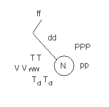
- The circle in the station model is centered on the latitude and longitude of the city where the weather observations are made.
- TT - Temperature: In the United States surface temperature is expressed in units of degrees Fahrenheit. In most other countries of the world it is expressed in degrees Celsius.
- TdTd Dew point temperature: Expressed in the same units as temperature.
- N - Cloud cover: Total cloud amount represents the fraction of sky covered by cloud.
- VV - Visibility: Howfar we can see, expressed in units of miles.
- dd - Wind direction: The line drawn represents the direction from which the wind is blowing. The pole points to the direction from which the wind is coming. You can tell which direction the pole is pointing by the end that has the flags or barbs.
- ff - Wind speed: The barbs on the lines representing wind direction give us information on the wind speed. Wind speed is measured in knots (1 knot =1.15 miles per hour). One long barb equals 10 knots, a short barb 5 knots and a triangle represents a wind speed of 50 knots.
- ww - present weather conditions: Symbols are used to convey information on the type of weather that was observed when the observations were made. Your book lists some of these symbols. A more extensive list does exist.
- PPP - Surface Pressure adjusted to sea level. The units are coded in mb. The leading 9 or 10 are dropped as is the decimal. So 234 represents a pressure of 1023.4 mb while 834 represents a pressure of 983.4 mb.
- pp
- Change in surface pressure over the last three hours. The change
in pressure is represented by a value and a
line that tells
us how
the pressure
was changing.
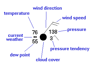
An example
In the following station plot the temperature is 76F, the dew point 55F,
the wind direction is northeast at about 20 knots. The pressure is 1013.8
mb, and it has increased then decreased and is now lower by 0.3 mb than
three hours ago. The cloud cover is overcast and it is raining.
Weather Symbols
|
|
|
|
|
|
|
|
|
|
|
|
|
|
|
|
|
|
|
|
|
|
|
|
|
|
|
|
|
|
|
|
|
|
|
|
|
|
|
|
|
|
|
|
|
|
|
|
|
|
|
|
|
|
|
|
|
|
|
|
|
|
|
|
|
|
|
|
|
|
|
|
|
|
|
|
|
|
|
|
|
|
|
|
|
|
|
|
|
|
|
|
|
|
|
|
|
|
|
|
|
|
|
|
|
|
|
|
|
|
|
|
|
|
|
|
|
|
|
|
|
|
|
|