| Lesson 3: Surface Weather Map |

An important part of studying meteorology is simply paying attention to weather conditions and applying your knowledge to what you observe. However, many different variables including temperature, moisture, cloudiness, precipitation, and others, are used to describe weather. All of these must be considered and analyzed numerically.
Furthermore, the weather at one location is often caused
by larger weather patterns. So it is not enough to consider the weather
locally.
We must also
analyze the weather for many other locations. This means even more
numbers.
To identify key weather-making patterns, we need to see all the numbers
describing
weather at many locations, all at once. It is also vital to see how
the observations
relate to each other geographically. A list of numbers doesn’t
help much; we
need a picture. So, we plot weather variables on a weather map to
understand the
relationships among them. To paraphrase the saying, “A picture
is worth a thousand
words,” a weather map is worth a thousand numbers—or
more. In this section, we
learn how to interpret weather maps.
Perhaps the most obvious features on weather maps are fronts. A front
is a
boundary between two regions of air that have different meteorological
properties,
such as temperature and humidity. A cold front denotes a region where
cold air is
replacing warmer air. A warm front indicates that warm air is replacing
cooler air.
All weather maps today depict frontal locations because they are
regions of rapidly
changing and sometimes dangerous weather conditions. The frontal
lines drawn
on a weather map represent the locations where the fronts meet the
Earth’s surface.
On a weather map, a blue line with blue triangles
indicates a cold
front. The triangles point in the direction the front is moving.
A warm front is shown
as a red line with red semi-circles pointing in the direction of
frontal movement. A
stationary front is a front that is not moving and is represented
as shown in the The occluded front, represented as a purple line with
alternating triangles and semi-circles, has characteristics of both
cold and warm
fronts.
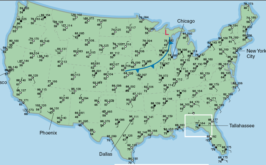
An example of a surface weather map is given above. It includes station model plots and a cold front attached to a low-pressure area over the upper Midwest United States.
Focusing on the station model for Tallahassee, Florida, in the inset above, we see that it is mostly cloudy there, the temperature is 77° F, the dew point temperature is 74° F, the sea-level pressure is 1018.4 mb, the winds are light and from the north, and Tallahassee is experiencing a thunderstorm. The weather observations were all made at the same time. This time is printed in the top right corner of each weather map. Unlike television programming, Eastern Standard Time is not the reference for these maps!