|
Past Wisconsin Climate
Your link to sources of long-term climate data from observing stations around Wisconsin ranging from decades to more than one century, thereby helping provide an indication of climate variability and long-term climate trends across the state.
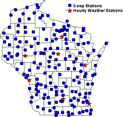
Wisconsin Climate Stations
Background
The State Climatology Office has a collection of climate data for
the state of Wisconsin that extends back into the 19th century.
Weather observations have been made in Wisconsin for approximately
180 years, starting with those made by the U.S. Army post surgeons
at Fort Howard (Green Bay), Fort Crawford (Prairie du Chien) and
Fort Winnebago (Portage) in the 1820s. Beginning in 1870, the U.S.
Army Signal Service operated a network of stations, which was the
forerunner to the National Weather Service. The network stations in
Wisconsin included Milwaukee, Madison and Green Bay. These stations
evolved into the first order stations of the US Weather Bureau at
the turn of the 20th century. Originally they were city offices, but
moved to the airports following World War II. With modernization of
the National Weather Service in the 1990s, automatic weather
stations are found at these metropolitan airports along with other
smaller airports. These stations typically provide hourly weather
data oriented toward aviation interests, to include temperature,
humidity, precipitation, wind speed/direction and air pressure. A
more extensive network of stations maintained by cooperative
observers became established by 1891 when the US Weather Bureau
continues across the state. This network is primarily responsible
for collecting daily weather data for agricultural and
climatological purposes. Currently, nearly 200 stations provide
maximum and minimum temperature readings along with precipitation
data on a daily basis.
List of
Wisconsin Weather Stations by County
Additional questions concerning finding data?
Check
Your Guide to Wisconsin
Weather and Climate Data
|