|
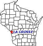
La Crosse Climate
Station Information
County Name: La Crosse
Division: 4 -
West Central
Latitude: 43 deg 45 min = 43.7539 N
Longitude: 91 deg 15 min = 91.2564 W
Elevation: 651 feet = 198 meters
Climate Normals
- Monthly Normals for temperature, degree days, precipitation, snow and growing season generated by NCEI:
- Normals for 1981-2010 from Midwestern Regional Climate Center
Daily Records
Temperature
Precipitation
- Daily Cumulative Precipitation
(commencing on 1 Jan)
(commencing on 1 Oct for Water Year)
- Long-term and Seasonal Precipitation (explanation): Spring, Summer, Autumn, Winter, Annual
and
for
Water Year
- Greatest daily precipitation total by year at
- La Crosse City Office (1896-1953)
- La Crosse Airport Office (1941-present)
- NOTE: Greatest calendar-day precipitation totals (based upon local midnight) at this station may not necessarily correspond with greatest 24-hour precipitation totals obtained from the hourly precipitation records.
- Number of Days per year with measurable precipitation (0.01 inches or greater) at
- Number of Days per year with one inch or greater precipitation at
- Daily
Precipitation Frequency Distribution for La Crosse
based upon 1971-2000 interval
Snowfall
(Snow season runs 1 July -30 June)
- Daily Cumulative Snowfall (not snow depth)
- Long-term seasonal snowfall (1891/92-present)
- Number of days per season with one inch or greater snowfall at
- La Crosse Airport Office (1948/49-present)
- Number of days per season with one inch or greater snow cover on the ground at
- Greatest daily snowfall total by season at
- La Crosse City Office (1891/92-1951/52)
- La Crosse Airport Office (1938/39-present)
- NOTE: Greatest calendar-day snowfall totals (based upon local midnight) at this station may not necessarily correspond with greatest 24-hour snowfall totals obtained from the hourly observational records.
- Maximum depth of snow cover on the ground at
- Average snow cover depth by season at
- Seasonal distribution of monthly average snow depth Airport (1981-2010)
- Frequency of occurrence of a White Christmas (1 inch or more of snow cover at 6 am on 25 December) at the La Crosse Airport (1951-2020)
Heating Degree Days (base 65°F; season runs 1 July - 30 June)
- Cumulative Heating Degrees
- Seasonal Heating Degrees at
Cooling Degree Days (base 65°F; season runs 1 January - 31 December)
- Cumulative Cooling Degrees
- Seasonal Cooling Degrees at
Growing Degree Days
(modified, base 50°F/ceiling 86°F; season runs 1 Jan - 31 Dec)
- Cumulative Modified Growing Degree Units for
- Long-term variations in Modified Growing Degree Day Units
Thunderstorm Climatology for La Crosse
- Annual number of thunderstorm days at Airport (1949-present)
- Seasonal distribution of thunderstorms Airport (1949-present).
- Plots of frequency of thunder reports by week and by hour (Courtesy of Iowa Environmental Mesonet - IEM)
Fog Climatology for La Crosse
- Plots of frequency of fog reports by week and by hour (Courtesy of Iowa Environmental Mesonet - IEM)
Wind Climatology for La Crosse
Additional questions concerning finding data?
Check Your Guide to Wisconsin Weather and Climate Data
|
|
|


