WEEKLY OCEAN NEWS
23-27 July 2018
Items of Interest:
- Shark Week 2018 runs this week --The Discovery Channel's Shark Week 2018, a week-long series of feature television programs dedicated to sharks, started on Sunday evening, 22 July. The week, which represents the 30th Shark Week, is also promoted on social media networks. Shark Week was first run in July 1987 in an effort to raise public awareness and respect for sharks. [The Discovery Channel]
- Zenithal Sun -- Residents of Hawaii's Big Island are experiencing a noontime sun that would be directly overhead during this past weekend and the start of this week (22-23 July). This occurrence of a zenithal sun is one of the two times during the year when the noontime sun is directly overhead to residents of Hilo and elsewhere on the Big Island. The other time when the Big Island experienced a zenithal sun was in mid May [US Naval Observatory, Data Services]
- July full moon and a long total lunar eclipse -- The moon will reach full moon phase this Friday afternoon (officially, 2020Z on 27 July 2018, or equivalently, 4:20 PM EDT and 3:20 PM CDT, etc.). The July full moon is called the "Thunder" or "Hay Moon."
At the time of this full moon, a total lunar eclipse will occur as the moon passes through the penumbra (lighter portion of the Earth's shadow) and the umbra (darker portion of the shadow). The time of greatest eclipse will be at 2021Z (4:21 PM EDT) Friday. This total lunar eclipse will be primarily an Eastern Hemisphere event, as it should be visible across nearly the entire Atlantic Ocean basin, including all of South America along with large sections of Europe, Africa, North America. Residents in North America will not be able to witness this eclipse. A figure on the NASA Eclipse Web Site shows the particulars of this eclipse.
Because of geometric considerations, this lunar eclipse will last 1 hour and 43 minutes, making it the longest lunar eclipse of the entire 21st century. The eclipse will be the century's longest since the moon will pass through the center of the cone representing the Earth's shadow and the eclipse will be occurring approximately 14 hours after lunar apogee (farthest Earth-moon distance), thereby reducing the apparent size of the lunar disk and increasing the length of time the moon travels in that portion of its elliptical orbit. In addition, this event can be called a "blood moon eclipse" since the lunar disk will appear to turn an impressive red or ruddy-brown color. This coloration is due to the filtering of a small amount of sunlight passing around the obscuring planet by the Earth's atmosphere, leaving only reddish colors reaching the lunar surface. [Space.com]
Ocean in the News:
- Eye on the tropics -- Tropical cyclone activity during this past week was focused on the western North Pacific basin.
- Tropical Depression 11W intensified to become Tropical Storm Son-tinh (or Tropical Storm 11W) by last Tuesday as it traveled westward near the northern coast of the Philippine Island of Luzon. During the week, Son-tinh crossed the South China Sea, then China's Hainan Island and the Gulf of Tonkin before making landfall along the northern coast of Vietnam on Thursday. After landfall, Son-tinh weakened into a tropical depression as it continued toward the west across Vietnam and into northern Laos. The remnant low reversing course and heading back across northern sections of Vietnam, passing across the capital city of Hanoi. As of this past weekend, the remnant low moved out over the Gulf of Tonkin where it reintensifed to become Tropical Depression Son-tinh on Saturday. Torrential rains accompanying Son Tin triggered flooding in northern Vietnam, including Hanoi, after this tropical storm made landfall in northern coastal areas on Thursday. According to official sources, Tropical Storm Son Tinh killed 20 people, injured 14 and left 16 missing in Vietnam. [Newhub] As of Monday (local time) Son-tin was moving to the northeast across Hainan Island, approximately 240 miles to the north-northeast of Da Nang, Vietnam. Son-tin should curve toward the north and then northwest over the early part of this week as it travels across coastal sections of mainland China. Additional information and satellite images for Tropical Storm Son-Tinh can be found on the NASA Hurricane Page.
- Tropical Depression 12W formed over the waters of the Philippine Sea last Wednesday. By Thursday, this tropical depression had strengthened to become Tropical Storm Ampil (or Tropical Storm 12W) as it was approximately 500 miles to the south of Okinawa. After traveling toward the east, Ampil curved toward the north and then to the north-northwest. Over the weekend, Ampil took aim on Shanghai, which received torrential rains and damaging winds as the center of Ampil passed just to the east of the city on Sunday. More than 190,000 people were forced to evacuate [Al Jazerra News]. By early Monday (local time) Tropical Storm Ampil was traveling toward the northwest along the coast of China. At that time, Ampil was located approximately 400 miles to the west-southwest of Kunsan Air Base located on the west coast of the South Korean Peninsula. Ampil was forecast to weaken as it continues along the Chinese coast and into northeast China by Wednesday. Flooding were expected to continue to be a problem across the region. The NASA Hurricane Page has satellite images and additional information on Tropical Storm Ampil.
Tropical Depression 13W (TD-13, which was also known as Josie) formed to the northwest of Luzon Island in the Philippines this past Saturday. Initially traveling to the east, TD-13 produced widespread rain to as far south as the capital city of Manila before it curved to the north and then to the north-northwest. As of early Monday,TD-13W was located approximately 160 miles to the east-southeast of Taipei, Tawain. TD-13W was forecast to travel toward the north-northwest passing near Shanghai on Tuesday and then continuing across the East China Sea toward the city of Qingdao on the east coast of China.
- Tropical Depression 14W (TD-14W) formed east of Minami Tori Shima, a Japanese coral atoll also known as Marcus Island, over the weekend. By early Monday, TD-14 had strengthened to become Tropical Storm 14W as it was tracking toward the northwest, approximately 330 miles to the east of Minami Tori Shima. The current forecast has TS-14W traveling toward the north, well to the east of most land areas. Eventually, this tropical system could become a sub-tropical low as it approaches the Kuril Islands northeast of Japan late this week.
- Tropical Depression 15W (TD-15W) formed in the western North Pacific over this past weekend. As of early Monday, TD-15W was located approximately 370 miles to the north-northwest of Yap in the Caroline Islands. Isang was forecast to intensify to become a tropical storm and then a typhoon by late Tuesday as it continues to track to the northwest, passing between Okinawa and Iwo Jima by Thursday.
NOTE: According to records at the Joint Typhoon Warning Center extending back to 1959, the five tropical cyclones that were found across the western North Pacific on Sunday, 20 July 2018, (Japan time) marked the first time since August 1960 that this many tropical cyclones were active at one time across the basin. [Stars and Stripes]
- National Hurricane Center's Tropical Analysis and Forecast Branch helps those sailing tropical waters -- Dr. Chris Landsea, the new chief of the National Hurricane Center's Tropical Analysis and Forecast Branch (TAFB) was recently interviewed about the operation of his branch. TAFB is the part of the National Hurricane Center that performs forecasting, outreach, and support functions. A group of meteorologists who specialize in marine meteorology, tropical meteorology, satellite imagery interpretation, and tropical weather analysis staff TAFB 24 hours a day, 365 days per year. [NOAA News Stories]
- Saharan dust stretches westward across tropical Atlantic this summer -- A meteorologist at NOAA's Climate Prediction Center wrote an "Event Tracker" blog for the ClimateWatch Magazine discussing the impacts of the large amounts of dust from Africa's Sahara Desert that were carried westward across the tropical Atlantic Ocean since late June. Some of the dust reached the Gulf of Mexico and the southern U.S. An animated sequence of seven natural-color satellite images obtained from the sensors onboard the NASA/NOAA Suomi NPP satellite during the span 6-12 July 2018 shows the tan-colored dust cloud from off the Sahara Desert being carried across the dark blue waters of the Atlantic to the Caribbean. He noted that the dust resulted in colorful sunsets, poor air quality in the southern U.S. and a suppression of tropical cyclone activity across the Atlantic basin during the first month of the basin's 2018 hurricane season. Furthermore, the Saharan dust provides mineral nutrients for phytoplankton in the ocean and helps fertilize South America's Amazon rainforests. Noting that these dust cloud events are not all that uncommon, he explains that the mineral dust often comes from the Bodélé depression, the lowest point in Chad, where dust storms occur as many as 100 days per year.
[NOAA Climate.gov News]
- Saildrones reach the Arctic Ocean off northwest Alaska -- The Alaska Regional Office of NOAA Fisheries posted a blog last week updating the progress of two saildrones that passed through the Bering Sea and entered the waters of the Chukchi Sea off the northwestern coast of Alaska. A saildrone is an instrumented autonomous sailing drone used to collect oceanic and atmospheric data. The two saildrones are participating in a mission designed to repeat an earlier conventional survey of the Chukchi Sea made by ships. The current blog is the third in the series. [NOAA Fisheries Science-blog]
- Public input sought on proposed reforms of the Endangered Species Act -- Late last week the U.S. Fish and Wildlife Service and NOAA Fisheries announced proposed revisions to certain regulations that implement portions of the Endangered Species Act (ESA) to ensure clarity and consistency. These changes will incorporate public input along with the best science and best practices to improve reliability, regulatory efficiency and environmental stewardship. Public comments to the proposed reforms are invited and must be submitted by late September, or within 60 days of publication in the Federal Register, which should occur within this week. [NOAA News]
- Satellite sees summer blooms in North American lakes -- Natural-color images generated from data collected by the NASA Landsat 8 satellite earlier this month show cyanobacteria blooms in western Lake Erie and Florida’s Lake Okeechobee. The cyanobacteria, which is also known as “blue-green algae,” are a regular summertime phenomenon on large lakes across North America. [NASA Earth Observatory]
- Large iceberg in Weddell Sea moves only a short distance in one year -- False-color images of Iceberg A-68 acquired nearly one year apart from the Thermal Infrared Sensor (TIRS) on NASA's Landsat 8 show that this iceberg has moved a relatively short distance across Antarctica's Weddell Sea between the end of July 2017 and the start of July 2018. Iceberg A-68 broke away from the Larsen C Ice Shelf on the Antarctic Peninsula in July 2017. [NASA Earth Observatory]
- Survey of world's beaches reveals threats to protected areas -- A team of engineers and scientists from the Netherlands developed a computer software scheme that permitted the rapid identification of the world's sandy beaches from 30 years of data obtained from the NASA/U.S. Geological Survey's Landsat satellites. The recently completed survey indicates that nearly one third (31 percent) of all ice-free shorelines are sandy or gravelly. The survey also indicates a slight increase in the world's sandy beaches over the past three decades, but a decrease was found in protected marine areas, where erosion was occurring. Approximately 24 percent of Earth's sandy beaches are eroding, representing a coastline distance of nearly 50,000 miles. The team claims that their research could help determine how the beaches and the associated ecosystems would respond to natural environmental changes and to the impacts due to human activity. [NASA Global Climate Change News]
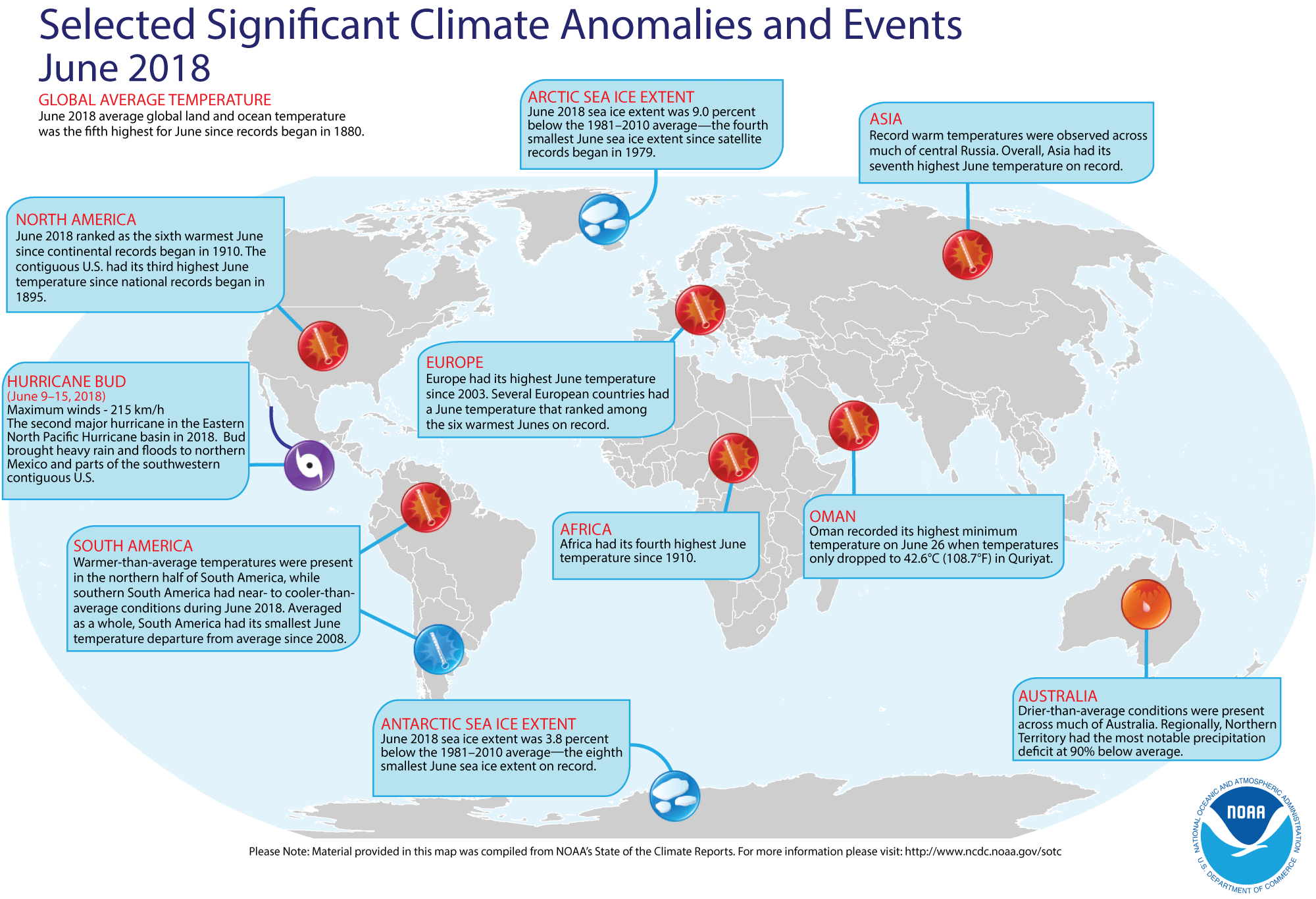
- Global temperature and ice cover for June 2018 reviewed -- Scientists at the NOAA National Centers for Environmental Information (NCEI)
recently reported on their analysis of preliminary weather data collected during the month of June 2018:
- The combined global land and ocean surface temperature for June 2018 was 1.35 Fahrenheit degrees above the 20th
century (1901-2000) average, which was the fifth highest temperature for any month of June since sufficiently detailed global climate records
began in 1880.
When considered separately, the average ocean temperatures for June 2018 was the sixth highest for
any June, while the average land surface temperature for this past month also was the sixth highest June land temperature during the 139-year record.
Furthermore, the average combined land-ocean temperature through the first six months of the year (January through June 2018) was the fourth highest for the first half of any year since 1880.
- The researchers at the National Snow and Ice Data Center noted the areal extent of the Arctic sea ice for June 2018 was the fourth smallest for the month since satellite surveillance began in 1979. In addition, the extent of the Antarctic sea ice was the eighth smallest in the 40-year record. [NOAA/NCEI
State of the Climate]
A global map of Selected Significant Climate Anomalies and Events for June 2018 is available from NCEI.
- An All-Hazards Monitor -- This Web portal provides the user information from NOAA's National Weather Service, FAA and FEMA on
current environmental events that may pose as hazards such as tropical
weather, fire weather, marine weather, severe weather, drought and
floods. [NOAA/NWS Daily Briefing]
- Earthweek -- Diary of the Planet [earthweek.com]
Historical Events:
- 23 July 1715...Boston Light, the first lighthouse in America was
authorized by the Boston Light Bill for construction at Little Brewster
Island, MA. This light, located on Little Brewster Island to mark the entrance
to Boston harbor, has guided ships since its lantern was first lighted just
before sunset, on 14 Sep 1716. In the 1600s, treacherous rocks caused
countless loss of lives. False signal fires lit in the wrong places by
"wreckers" lured ships aground to plunder. Boston Light was blown up by the
British in 1776, but rebuilt in 1783 by Governor John Hancock. The lighthouse
was also the last remaining staffed station in the U.S. (Today in Science
History)
- 23 July 1788...A weather diary kept by George Washington recorded that the
center of a hurricane passed directly over his Mount Vernon home. The
hurricane crossed eastern North Carolina and Virginia before moving into the
Central Appalachians. Norfolk, VA reported houses destroyed, trees uprooted,
and crops leveled to the ground. (David Ludlum)
- 23 July 1958...USS Nautilus (SSN-571) departed Pearl Harbor, Hawaii
for the first submerged transit of the North Pole. (Naval Historical Center)
- 23 July 1982...The International Whaling Commission decided to end
commercial whaling by 1985-86. (Wikipedia)
- 24 July 1609...A fleet of ships carrying colonists to the New World met
with a hurricane near Bermuda, resulting in much loss of property but little
loss of life. (Northern Indiana NWSFO)
- 24-25 July 1979...Claudette, a weak tropical storm, deluged southeastern
Texas with torrential rains. The Houston suburb of Alvin received 43.00
inches, a 24-hour precipitation record for not only the Lone Star State, but
for the U.S. Freeport reported a total of 30 inches. Total damage from
flooding was over $400 million. On the 27th, a van loaded with
people on their way to a church camp stopped on Texas Highway 7 due to a
flooded bridge just west of Centerville. A truck rammed the van, pushing it
into the flooded creek, resulting in five people drowning. (Intellicast)
(David Ludlum) (NCDC) (Accord's Weather Guide Calendar)
- 24-26 July 1996...Although thousands of miles from southern California, an
intense South Pacific storm south of Tahiti produced seven- to ten-foot surf
with some sets up to 12 feet along the southern California coast. Lifeguards
participated in more than 500 rescues along the beaches. (Accord's Weather
Guide Calendar)
- 25 July 1956...The Italian ship Andrea Doria sank in dense fog near
Nantucket Lightship, MA. Ten hours earlier, the ship was rammed by the
Swedish-American liner, Stockholm, forty-five miles off the coast of
Massachusetts. Fifty-two persons drowned, or were killed by the impact. (David
Ludlum) (The Weather Channel)
- 25 July 1988...A storm system brought heavy rains to Tasmania, Australia. Coastal areas were flooded by high tides and storm surge. (National Weather Service files)
- 25 July 1994...Hurricane Gilma, like Emilia a week earlier, reached
Category 5 strength in the Central Pacific. (Intellicast)
- 26 July 1979...Tropical Storm Claudette stalled over Alvin, Texas, inundating the town with 45 inches of rain in 42 hours. The total included 43 inches in 24 hours, which is the maximum 24-hour rainfall in American history. (National Weather Service files)
- 27 July 1819...Several dozen people were killed in the Bay St. Louis Hurricane. Some of the fatalities were from alligator and snake bites when the animals were driven into the streets of Mobile, AL. (National Weather Service files)
- 27 July 1866...The 1686-mile long Atlantic Cable was successfully
completed between Newfoundland and Ireland by the American businessman Cyrus
W. Field, allowing transatlantic telegraph communication for the first time.
Two previous attempts at laying a cable ended in failure. (Wikipedia) (Today
in Science History)
- 27 July 1926...A hurricane came inland near Daytona Beach, FL. The
hurricane caused 2.5 million dollars damage in eastern Florida, including the
Jacksonville area. It had been a Category 4 hurricane when it crossed the Bahamas. (David Ludlum)
- 27 July 1943...On a whim, and flying a single engine AT-6, Lieutenant
Ralph O' Hair and Colonel Duckworth were the first to fly into a hurricane. It
started regular Air Force flights into hurricanes. (The Weather Channel)
- 28 July 1819...A small but intense hurricane passed over Bay Saint Louis, MS. The hurricane was considered the worst in fifty years. Few houses were left standing either at Bay Saint Louis or at Pass Christian and much of the Mississippi coast was desolate following the storm. An U.S. cutter was lost along with its thirty-nine crewmembers. The storm struck the same area that was hit 150 years later by Hurricane Camille. (David Ludlum)
Return to RealTime Ocean Portal
Prepared by AMS Ocean Central Staff and Edward J. Hopkins,
Ph.D.,
email hopkins@aos.wisc.edu
© Copyright, 2018, The American Meteorological Society.