In recent years, Earth-orbiting satellites have become important tools for the oceanographer. While meteorologists have used satellites as platforms to monitor the state of the atmosphere for more than 40 years, oceanographers have utilized satellites in investigating the ocean for less than 30 years. Part of the reason why oceanographers did not use satellites as early as meteorologists is because the sensors onboard satellites cannot probe the ocean waters to great depths. Instruments onboard essentially all environmental satellites sense the intensity of electromagnetic radiation coming from the planet in many wavelength bands (channels) within the electromagnetic spectrum. Some satellites are equipped with sensors that detect microwave signals that were emitted by devices onboard the satellite and are reflected by Earth's surface back to the satellite.
Initially, oceanographers were limited to using data from satellites to study processes occurring at the ocean-atmosphere interface. However, in recent years, oceanographers have developed a variety of methods that permit them to draw inferences about the state of the ocean at some depth. Some of the applications currently used by oceanographers include determination of the thermal properties of the ocean, analysis of air-sea interactions, monitoring of ocean waves, determination of sea-level, analysis of ocean currents and eddies, and determination of biological production. In addition, satellites are used to relay oceanographic data obtained from a variety of sensors on buoys or submersible vehicles. These satellites also play an important role in search and rescue operations on the high seas or other remote locations.
The National Aeronautics and Space Administration (NASA), the National Oceanic and Atmospheric Administration (NOAA), and the Department of Defense (DOD) operate a variety of satellites that provide remote sensing of the Earth system including the ocean. The course website allows you to access some of the current NASA and NOAA satellite products used operationally and for oceanographic research. You can investigate some of the satellite products provided by NOAA's CoastWatch Program found in the link marked "NOAA Satellite Imagery."
HISTORICAL BACKGROUND
The early weather satellites initially provided oceanographers with a view of the state of the atmosphere over the world ocean, helping them locate storm systems and ice cover in typically data-void locations. The first satellite used primarily for meteorological purposes was TIROS I, a polar orbiting satellite, launched by the United States in April 1960. During the next 40 years, improved polar orbiting satellites have been deployed. These Polar Operational Environmental Satellites (POES) have a low-altitude orbit and provide pole-to-pole surveillance. The military operates polar orbiting satellites in its Defense Meteorological Satellite Program (DMSP) that monitor the atmospheric and oceanic environments.
The first geosynchronous (known more imprecisely as geostationary) satellites launched by NASA (National Aeronautics and Space Administration) during a span from late 1968 through 1974 collected and transmitted meteorological data. These satellites are placed in a synchronous equatorial orbit with the Earth. Since 1975, the geosynchronous satellites operated by the United States for weather surveillance have been in the GOES (Geostationary Operational Environmental Satellites) series. Currently, the U.S. operates two GOES satellites, one monitoring the Atlantic basin along with eastern North America, and the other monitoring much of the Pacific basin and western North America. Other geosynchronous satellites operated by the Japanese and the European satellite communities provide essentially global coverage of the world's major ocean basins.
In 1978, the U.S. launched SEASAT as one of the first specialized oceanographic satellites to study the global ocean using microwave sensors. This satellite collected information on sea surface winds, sea surface temperatures, wave heights, internal waves, currents, tides, the marine geoid, atmospheric water content, sea ice features, and ocean topography. Unfortunately, the onboard sensors failed less than four months after launch.
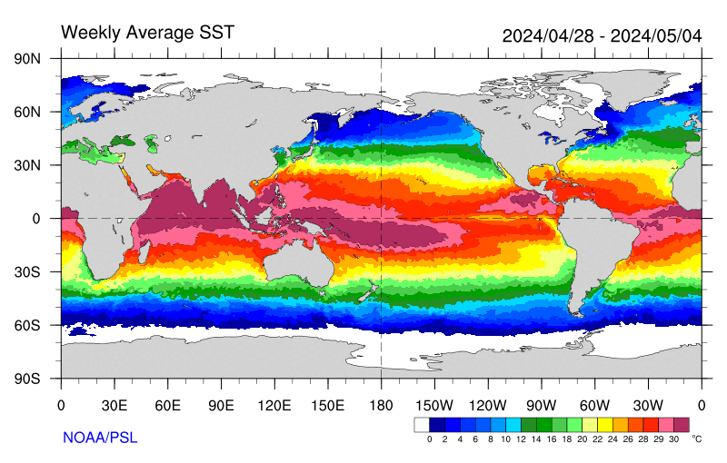
SEA SURFACE TEMPERATURES AND THERMAL PROPERTIES
Oceanographers use data retrieved from weather satellites to study the energy budget at the ocean surface. Visible satellite images are maps of the reflected sunlight in the visible spectrum, meaning that the reflectivity of the ocean surface could be measured. Therefore, the amount of incoming sunlight that is absorbed and utilized in the ocean could be determined. Infrared satellite images are maps of the infrared radiation emitted from various components of the Earth-atmosphere system, which equivalently, are maps of the surface temperatures of these components. Hence, some estimate of the energy loss or gain at the ocean surface could also be made. Currently, the POES satellites have an Advanced Very High Resolution Radiometer (AVHRR) that permits the generation of a variety of maps of current sea surface temperature (SST). A new set of instruments, called Moderate Resolution Imaging Spectroradiometer (MODIS), onboard NASA's polar orbiting satellites also determines SST. Current SST charts of the global ocean can be found on the course website at the Sea Surface Temperatures link.
OCEAN COLOR
One of the polar orbiting satellites launched for meteorological purposes (NIMBUS-7 in 1978) was also equipped with a sensor package called Coastal Zone Color Scanner (CZCS) that could detect the sunlight reflected from chlorophyll in both land and marine plants. The color of the most of the world ocean depends primarily upon the abundance of marine phytoplankton. Thus, this sensor, which remained operational until 1986, provided the oceanographic community with some of the earliest images of the world production of marine plant life. Currently, ocean color is monitored by several polar orbiting satellites that have the Sea-viewing Wide Field-of-view Sensor (SeaWiFS) and MODIS sensors. Current images of ocean productivity can be obtained from the course website at the Ocean "Color" link.
OCEAN SURFACE WINDS
Beginning with SEASAT, attempts have been made to monitor the surface wind speed and direction from space. A variety of instruments onboard satellites have been employed, including active microwave sensors that emit radar signals to determine wind direction and passive or radiometer microwave sensors. NASA has a SeaWinds instrument on its Quick Scatterometer (QuikSCAT) satellite, which is a microwave sensor used to measure the reflection or scattering effect produced while scanning the ocean surface. Recently, a polarimetric radiometer has been placed on the new WINDSAT satellite that utilizes polarization effects.
SEA SURFACE TOPOGRAPHY
Variations in the height of the sea surface are caused by spatial variations in gravity as well as seasonal changes in atmospheric and oceanic circulation patterns. Changes in height can also allow oceanographers to determine the heat content of the ocean. TOPEX/Poseidon and Jason satellites have employed radar altimeters to collect data on the sea surface height for the entire world ocean. Current data on sea surface topography can be obtained from the course website at the Sea Surface Heights link.
SEA ICE EXTENT
Monitoring the areal extent, amount, and thickness of sea ice in the polar ocean is important for oceanographers. While visible satellite images could be used to monitor the extent of the sea ice in both the Arctic Ocean and in the Southern Ocean surrounding Antarctica, darkness and clouds present a problem. Operational ice analyses now employ passive microwave sensors onboard polar orbiting satellites. Current images of ocean ice cover can be obtained from the course website at the Global Ice Extent link.
OTHER SATELLITE PRODUCTS
The NASA Earth Science satellite mission includes a fleet of low, polar orbiting satellites, such as Aqua and Terra, with a variety of instruments that collect large data sets, some of which are important for oceanography. One of the instrument packages on these NASA satellites is the Moderate Resolution Imaging Spectroradiometer (MODIS). High-resolution images are constructed from the data collected by these sensors; these images are of near-photo quality because of their 300-meter resolution. Throughout the course, links will be provided in the Weekly Ocean News to some of the recent MODIS images that show interesting oceanic and marine weather phenomena.
Return to RealTime Ocean Portal
Prepared by Edward J. Hopkins, Ph.D., email hopkins@aos.wisc.edu
© Copyright, 2018, The American Meteorological Society.