Weekly Ocean News
23-27 April 2018
Item of Interest:
- National Science Bowl set for next weekend -- The
US Department of Energy (DOE) National Science Bowl®, a nationwide
academic competition for middle and high school students will be held
through next weekend (26- 30 April 2018) in Washington, DC. This event
will test students' knowledge in all areas of science and is meant to
encourage high school students to excel in science and math and to
pursue careers in those fields. [DOE Office of Science]
- Accessing and interpreting climate data -- If you would like to obtain a variety of climate data for your home
town or state that are available from the National Weather Service,
please read this week's Supplemental
Information...In Greater Depth.
This Supplemental not only identifies some of the sites to find the
data, but also provides you with a brief explanation of the terminology
used to identify the climate data.
Ocean in the News:
- Eye on the tropics -- No tropical cyclones were detected across any ocean basin during the last week.
- The 2017 hurricane season reviewed -- The 2017 hurricane season in the North Atlantic along with the eastern and central North Pacific is
reviewed and compared to the more than 150 years of record keeping in the North Atlantic and the 40 years in the eastern North Pacific. [AMS DataStreme Atmosphere]
- Hurricane awareness tour commences to Mexico and the Caribbean -- NOAA and US Air Force Reserve hurricane experts will embark at the start of this week (23-28 April 2018) on a six-day, five-city tour to Mexico, Panama, Jamaica and Puerto Rico in a "hurricane hunter" aircraft designed to raise public hurricane awareness in communities in several countries surrounding the Caribbean Sea. A series of events will be hosted that would include tours aboard the Air Force Hurricane Hunter aircraft and a high-altitude research jet that NOAA uses. [NOAA Media Release]
- Ocean acidification buoy is launched to track changing coastal chemistry in Chesapeake Bay -- A new buoy was deployed in early April near Cape Henry, VA at the mouth of Chesapeake Bay that is designed to monitor how increasing concentrations of atmospheric carbon dioxide and increased ocean acidification impact the bay and its valuable shellfish. The new buoy is located beside the First Landing Chesapeake Bay Interpretive Buoy System site that is operated by the NOAA Chesapeake Bay Office to maximize collaboration with existing research and observations. [NOAA Office of Oceanic & Atmospheric Research News]
- Mission is underway to explore deep-sea habitats in Gulf of Mexico -- A 23-day scientific mission began two weeks ago as the NOAA Ship Okeanos Explorer departed Pascagoula, MS to collect baseline information on poorly understood deep-sea habitats in the Gulf of Mexico. Live video feeds can be watched to follow the expedition. [NOAA National Centers for Coastal Ocean Science News]
NOAA's National Centers for Environmental Information is supporting the Office of Ocean Exploration and Research in its efforts to catalog, archive and provide access to data collected by the Okeanos Explorer. Online access is made available to information about the ship's current expeditions through the "Okeanos Explorer Atlas," while the data archived from the more than 87 missions conducted by the Okeanos Explorer since 2008 have been made available through the "OER Digital Atlas." [NOAA NCEI News]
- Record low winter sea ice in Alaska's Bering Strait creates problems for coastal communities -- During the last week, the International Arctic Research Center at the University of Alaska Fairbanks produced a four-page summary of the winter 2018 sea ice conditions in and around the Bering Strait off Alaska's western coast. The amount of sea ice in the Bering Sea was the lowest since 1850, the result of unusual winter conditions that have prevailed in the region, involving above average air and water temperatures and more frequent storms with an increased frequency of winds from the south. The lack of persistent sea ice this winter caused a variety of problems for coastal communities. [NOAA Climate.gov News] or [University of Alaska Fairbanks International Arctic Research Center]
- NOAA data are available to help the nation's fishers -- NOAA's National Centers for Environmental Information (NCEI) serves as the nation's chief repository of oceanographic and coastal data. Third-party fishing forecasters, along with commercial and recreational fishers can use these data to assist in finding where fishing conditions are promising.
[NOAA NCEI News]
- Drones are evaluated for mapping a coast and nearshore waters -- During the month of March, scientists from NOAA's National Centers for Coastal Ocean Science and their colleagues tested drones and the associated technology needed the coastline and nearshore waters of St. Croix in the U.S. Virgin Islands. Three different drones were used under a variety of conditions in the evaluation of the quality of land elevation and water depth data acquired by the drones. These land elevation and water depth data are needed to make informed management decisions about the coastal zone. [NOAA National Centers for Coastal Ocean Science News]
- New instrumentation being developed to increase views of ocean-atmosphere interactions -- Scientists at NASA's Jet Propulsion Laboratory have been developing a new Earth science radar instrument called DopplerScatt, a spinning radar unit that "pings" the ocean's surface, allowing it to take measurements from multiple directions at once. Flying onboard an aircraft, DopplerScatt will provide a new capability to measure both winds and currents simultaneously. [NASA Armstrong Flight Research Center Feature]
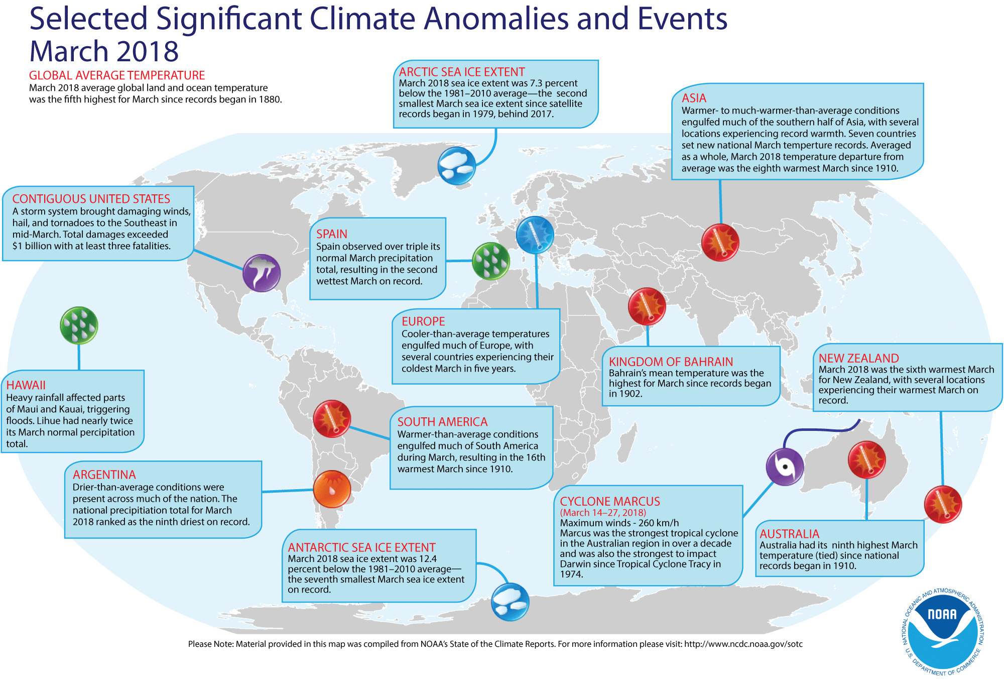
- Review of global weather and climate for March 2018 -- Using preliminary data collected from the global network of surface weather stations, scientists at NOAA's National Centers for Environmental Information (NCEI) have determined that the combined global land and ocean surface temperature for March 2018 was the fifth highest for any March since sufficiently detailed global climate records began in 1880. This global temperature for March 2018 was 1.49 Fahrenheit degrees above the 20th century (1901-2000) average.
When considered separately, the average land temperature for March 2018 was the seventh highest land temperature for any March in the 139-year period of record. Last month's average temperature over the oceans was the fifth highest for any March. Interestingly, the March 2018 monthly global combined sea-land temperature departure from the 20th century average represents the smallest March temperature departure from average since 2014.
The researchers at the National Snow and Ice Data Center noted the areal extent of the Arctic sea ice for March 2018 was the second smallest since satellite surveillance began in 1979. In addition, the extent of the Antarctic sea ice was the seventh smallest in the 39-season record. According to data from the Rutgers Global Snow Lab, the Northern Hemisphere snow cover extent for March was the 13th largest in the 52-year period of record of satellite observations. [NOAA/NCEI State of the Climate] A global map of Selected Significant Climate Anomalies and Events for March 2018 is available from NCEI.
A summary article describing the global climate for March and the year to date is available. [NOAA News] - Corals on Australia's Great Barrier Reef could survive global warming for another century -- Researchers from the University of Texas at Austin, Australia's University of Melbourne and the Australian Institute of Marine Science claim that corals in Australia's Great Barrier Reef have sufficient genetic variation to adapt to and survive rising ocean temperatures for at least another century, or more than 50 years longer than previous estimates have suggested. [University of Texas at Austin News]
- Large quantities of carbon are being absorbed along North American East Coast -- A team of scientists from seven research institutions across the nation recently reported on their research involving the construction of a carbon budget of the tidal wetlands, estuaries, and shelf waters of eastern North America using historical data and a variety of models. The researchers claim that coastal waters play an important role in the carbon cycle by absorbing approximately 20 percent of the carbon into wetland soils or nearshore sediments, while transferring the other 80 percent to the open ocean. [Lamont-Doherty Earth Observatory News]
- An All-Hazards Monitor -- This Web portal provides the user information from NOAA's National Weather Service, FAA and FEMA on
current environmental events that may pose as hazards such as tropical
weather, fire weather, marine weather, severe weather, drought and
floods. [NOAA/NWS Daily Briefing]
- Earthweek -- Diary of the Planet [earthweek.com]
Concept of the Week: Climate Feedback
Processes
Earth's climate system includes many interacting variables.
Some variables are external to the Earth-atmosphere system and some are
internal. External variables include solar energy output and Earth-sun
geometry (i.e., the Milankovitch cycles). Internal variables include
properties of the Earth's surface (e.g., albedo, moisture), the
concentration of key atmospheric components (e.g., greenhouse gases,
sulfurous aerosols), and cloud cover and thickness.
An important consideration in understanding how Earth's
climate system responds to some perturbation is feedback. Feedback is defined as a sequence of interactions among variables in a
system that determines how the system responds to some initial
perturbation in one or more of the variables. Variables in Earth's
climate system may interact in such a way as to either amplify (positive
feedback) or lessen (negative feedback) a
change in climate. An example of positive feedback is the ice-albedo
effect described in Chapter 12 of the DataStreme Ocean textbook.
Less ice cover in the Arctic greatly reduces the albedo of the Arctic
Ocean causing higher sea surface temperatures and accelerated melting
of the multiyear pack ice.
Consider an example of negative feedback. Increasing
concentrations of atmospheric carbon dioxide enhances the greenhouse
effect causing global warming. Global warming in turn raises sea
surface temperatures and increases the rate of evaporation. A more
humid atmosphere means more persistent and thicker cloud cover, but
clouds have both a cooling and warming effect on the lower atmosphere.
The relatively high albedo of cloud tops causes cooling whereas
absorption and emission of infrared radiation by clouds causes warming
by contributing to the greenhouse effect. Satellite measurements and
numerical models indicate that cooling would dominate.
In general, negative feedback tends to dominate over positive
feedback in Earth's climate system, limiting the magnitude of climate
change. The great thermal inertia of the ocean is the principal reason
for dampening the planetary temperature response.
Historical Events:
- 23 April 1792...John Thomas Romney Robinson, inventor of the cup anemometer, was born. (National Weather Service files)
- 23 April 1924...A tube transmitter for radio fog-signal
stations, developed to take the place of the spark transmitters in use,
was placed in service on the Ambrose Channel Lightship and proved
successful. (USCG Historian's Office)
- 24 April 1884...USS Thetis, Bear,
and Alert sailed from New York to search for
Greeley expedition lost in the Arctic. (Naval Historical Center)
- 24 April 1928...The fathometer was patented by Herbert
Grove Dorsey (No. 1,667,540). The invention measured underwater depths
by using a series of electrical sounds and light signals. (Today in
Science History)
- 26 April 1991...200,000 people were killed as a cyclone caused tremendous flooding which devastated the Bay of Bengal region of Bangladesh and India. (National Weather Service files)
- 27 April 1521...The Portuguese navigator Ferdinand Magellan
was killed by natives during a tribal skirmish on Mactan Island in the
Philippines after completing nearly three-quarters of a trip around the
world. One of his ships, the Victoria, under the command of the Basque
navigator Juan Sebastiýn de Elcano, continued west to arrive at
Seville, Spain on 9 September 1522, the first ship to circumnavigate
the globe. (The History Channel)
- 28 April 1947...Norwegian anthropologist Thor Heyerdahl and
five others set out in a balsa wood craft known as Kon Tiki to prove
that Peruvian Indians could have settled in Polynesia. The trip took
101 days.
- 29 April 1770...The British explorer, Captain James Cook,
arrived at and named Botany Bay, Australia. (Wikipedia)
Return to DataStreme Ocean's RealTime Ocean Portal
Prepared by AMS Ocean Central Staff and Edward J. Hopkins,
Ph.D.,
email hopkins@aos.wisc.edu
© Copyright, 2018, The American Meteorological Society.