Weekly Ocean News
26-30 March 2018
Items of Interest:
- Tsunami Awareness Week -- Tsunami
Preparedness Campaigns continue. California will be conducting its 2018 Tsunami Preparedness Week during this week (26 -30 March 2018)[The TsunamiZone]
The entire week is Tsunami Preparedness Week in Alaska.
[Governor's Office for State of Alaska]. The state government in Alaska has also established the 27th of each March to be 1964 Alaska Earthquake Remembrance Day in observance of the anniversary of the series of devastating tsunamis that struck southeastern Alaska following several major earthquakes. Additional information is also available for the Great Alaskan earthquake and tsunami of 1964. [NOAA NCEI Nation]
On Monday, 26 March, the Pacific Tsunami (PACIFEX18) Exercise will be conducted near the Shumagin Islands, which are located off the tip of the Alaska Peninsula.
- Sun sets for six months at the South Pole Station -- The occurrence of the vernal equinox last Tuesday marks the time of year when the Sun is about to set below the local horizon at the South Pole for the next six months. A photograph was made last Tuesday of the setting Sun at NOAA's South Pole Atmospheric Baseline Observatory at the U.S. Amundsen-Scott South Pole Station. Flags from the nations participating in Antarctic research surround the ceremonial South Pole marker. [NOAA Stories]
- A participant in NOAA's Teacher at Sea Program describes her experiences -- Mary Cook, who is a teacher at Scammon Bay, AK describes her experiences working at sea as a participant in NOAA's Teacher at Sea Program during a 4-minute video. She explains how the program makes a tremendous impact locally, regionally, and nationally on science education teaching and learning. [NOAA Fisheries Video]
- Marine and tropical weather statements --
This week's Supplemental
Information...In Greater Depth identifies those
National Weather Service Forecast Centers that monitor the weather,
prepare weather forecasts, and issue event-specific warnings or
advisories for marine and coastal interests. The terminology used to
identify the particular warnings, watches and advisories for marine
interests and for tropical weather events is also discussed.
Ocean in the News:
- Eye on the tropics -- During the last week, tropical cyclones were reported across the South Indian Ocean and western sections of both the South Pacific and North Pacific Oceans:
- In the western South Indian Ocean basin Tropical Cyclone Eliakim was traveling along the eastern coast of Madagascar at the start of last week. By late Tuesday (local time), Eliakim was beginning to dissipate approximately 580 miles to the south of St. Denis, La Reunion Island. The NASA Hurricane Page has satellite images and additional information on Tropical Cyclone Eliakim.
In the eastern South Indian Ocean basin, Cyclone Marcus was battering the far northern sections of the Kimberly region of Western Australia with strong winds and torrential rains. As of early Monday (local time), the center of Cyclone Marcus was located approximately 290 miles to the northeast of Broome, Western Australia. Marcus was classified to be a category 3 tropical cyclone according to the Australian system. (Editor's note: According to Australia's Bureau of Meteorology, category 1 and category 2 tropical cyclones that are found in the waters around Australia are tropical storms according to U.S. nomenclature; a severe category 3 tropical cyclone is equivalent to a category 1 hurricane on the Saffir-Simpson Scale. EJH) Traveling westward away from the Australian coast during the first half of last week, Marcus intensified to become a category 5 tropical cyclone on the Saffir-Simpson Scale by Thursday, as maximum sustained surface winds reached an estimated 160 mph. Consequently, Marcus represents the strongest tropical cyclone of the 2017-18 Australian region cyclone season and the strongest tropical cyclone in the Australian region since George in 2007. By late week, Marcus had curved to take a track toward the southwest and then toward the south. As of early Sunday (local time), Marcus was located approximately 520 miles to the southwest of Learmonth, Australia. Consult the NASA Hurricane Page for satellite imagery and additional information on Cyclone Marcus.
- In the western South Pacific, Tropical Storm Nora formed early last Friday (local time) over the waters of the Arafura Sea, which is located between Australia and Indonesian New Guinea. Nora strengthened as it traveled toward the east and then southeast across the Gulf of Carpentaria over this past weekend, becoming category 4 tropical cyclone on the Australian category scale or a category 2 tropical cyclone on the Saffir-Simpson Scale. Nora made landfall along the western coast of Cape York as a category three cyclone (Australian nomenclature) near Pormpuraaw on Saturday night, accompanied by torrential rains that produced flooding [abc.net News]. By early Monday, remnants of Nora were moving across interior sections of Queensland, Australia. Additional information and satellite imagery are available from the NASA Hurricane Page for Cyclone Nora.
Tropical Storm Iris formed this past Sunday (local time) approximately 650 miles to the west of the island nation of Vanuatu. This tropical storm was traveling toward the south-southwest on Sunday. As of Monday morning, Iris was located approximately 650 miles to the northwest of Noumea, New Caledonia. Iris was forecast to continue its track toward the south during the first half of this week with little intensification.
- In the western North Pacific, Tropical Depression Jelawat formed on Sunday morning (local time) approximately 300 miles to the south-southeast of Yap an island in the Federated States of Micronesia. This tropical depression was traveling toward the west-northwest on Sunday, with some intensification. As of Monday morning, Jelawat was located approximately 55 miles to the south of Ngulu Atoll, a coral atoll in the Caroline Islands. Current forecasts indicate that Jelawat could intensify possibly to a category 1 typhoon on the Saffir-Simpson Scale by midweek as it heads northward and then to the north-northeast, out over the open waters of the western North Pacific.
- Mapping the Earth's ocean basins -- Seabed 2030 is an international collaborative project between General Bathymetric Chart of the Oceans (GEBCO) and the Nippon Foundation that is aiming to complete mapping of the ocean floor by the year 2030. Scientists with NOAA's National Centers for Environmental Information (NCEI) and other institutions are participating in this Seabed 2030 project, including developing an algorithm that will cultivate a seabed mapping for the ocean basins, commencing with the North Atlantic. High-quality bathymetric maps are necessary for a variety of regions, including the designation of marine protected areas to conserve threatened ecosystems or habitats, the prediction of tsunami inundation, fisheries management and military defense applications. [NOAA NCEI News]
- Law on seafood imports is strengthened -- The director of the Office of International Affairs and Seafood Inspection in NOAA Fisheries wrote a message to the public last Friday showing appreciation for the U.S. Congress' support for the Seafood Import Monitoring Program in the FY2018 Omnibus Appropriations Bill. The congressional action lifts the stay on shrimp and abalone inclusion in the Seafood Import Monitoring Program, and establishs a domestic aquaculture traceability program. This Seafood Import Monitoring Program is deemed critical to curbing Illegal, Unreported and Unregulated fishing and ensuring that seafood imported into the U.S. is legally harvested and truthfully represented. [NOAA Fisheries Leadership Message]
- Nine new committee members appointed to NOAA's Marine Fisheries Advisory Committee -- Secretary of Commerce Wilbur Ross recently appointed nine new advisors to NOAA's Marine Fisheries Advisory Committee, which advises the Secretary of Commerce and NOAA on all living marine resource matters that are the responsibility of the Department of Commerce. The addition of these new members brings the group's membership to the full complement of 21. [NOAA Fisheries Feature Story]
- National coastal vulnerability is addressed -- A NOAA technical report entitled "Patterns and projections of high tide flooding along the U.S. coastline using a common impact threshold" was recently released that intends to provide an objective and nationally consistent set of impact thresholds for minor/moderate/major coastal flooding. The report was made by sea level experts from NOAA's Center for Operational Oceanographic Products and Services, who looked at existing flood thresholds established by the National Weather Service. They found patterns in the thresholds based upon tide range, which permitted them to apply that pattern nationwide and find a statistical and consistent way to measure and monitor minor high tide flooding, as well as moderate and major flooding in locations where no threshold exists. [NOAA National Ocean Service News]
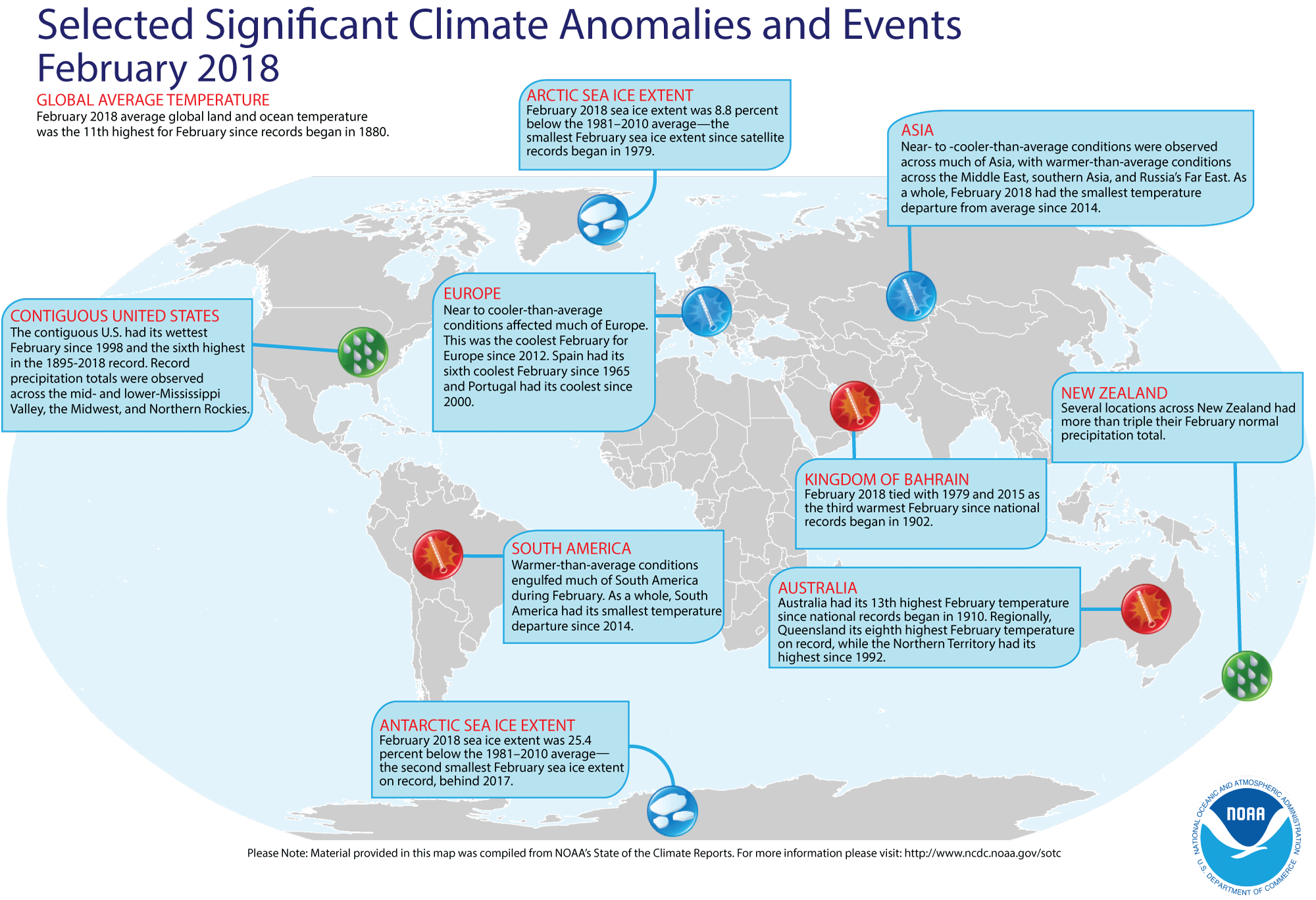
- Review of global weather
and climate for February 2018 -- Using preliminary data collected from the global network of surface weather stations, scientists at NOAA's National Centers for Environmental Information (NCEI) have determined that the combined global land and ocean surface temperature for February 2018 was 1.17 Fahrenheit degrees above the 20th century (1901-2000) average, which represents the eleventh highest global average February temperature since comprehensive global climate records began in 1880. Individually, the global ocean surface temperature for this past month was the seventh highest global ocean temperature highest in the 139-year period of record, while the average global land surface temperature for February 2018 was the fifteen highest.
Furthermore, the three-months running from December 2017 through February 2018 that constitute meteorological winter in the Northern Hemisphere (and meteorological summer in the Southern Hemisphere) had the fifth highest three-month average combined global temperature for any such interval since 1880/81. The December-February globally averaged land surface temperature was the seventh highest for December-February in the 139-year record, while the globally averaged sea surface temperature for the same three months was the sixth highest for December-February in the record.
[State of the Climate/NCEI]
NCEI also provides a map showing the Global Significant Weather and Climate Events map for February 2018.
According to the National Snow and Ice Data Center, the extent of the Arctic sea ice for this past February was the smallest monthly extent for any February in the basin since satellite surveillance began in 1979, while the extent of the sea ice surrounding Antarctica was the second smallest February sea ice on record. Furthermore, the Arctic sea ice extent appeared to have reached its annual maximum extent one week ago in mid-March, which was five days later than normal compared to the 1981-2010 median date of 12 March. [ National Snow and Ice Data Center] At the same time, the Antarctic summer minimum extent also reached a new record low. [NOAA Climate.gov News]
The extent of the Northern Hemisphere snow cover during February 2018 according to the Rutgers Global Snow Lab was the 19th largest for the 52-year period of record that started in 1967. [NOAA/NCEI Global Snow & Ice]
- Air bubbles could help prevent hurricanes from causing destruction -- Norwegian researchers at SINTEF, the largest independent research organization in Scandinavia, claim that a tested method called a "bubble curtain" involving cold compressed air bubbles could be used to save lives from landfalling hurricanes. The compressed air is supplied through a perforated pipe, which cause bubbles to rise and carry colder water to the surface, thereby lowering the surface water temperatures to be lowered sufficiently to cut off the hurricane's energy supply. Norway has been using bubble curtains for many years to keep the country's fjords free of ice. [SINTEF News]
- A "heat wave" spreads across the Arctic basin in February -- A staff member of the National Snow and Ice Data Center posted an "Event Tracker" blog in the ClimateWatch Magazine describing the much above average temperatures that were reported during the month of February 2018 across a large area of the Arctic basin, where average monthly temperatures were as much as 25 to 35 Fahrenheit degrees above the current 30-year normals (1981-2010). Some locations in Greenland reported daily maximum temperatures at the end of February that were nearly 45 Fahrenheit degrees higher than normal. To place these temperature anomalies in perspective, the author provided a table in which a 45-Fahrenheit degree temperature increase was added to the normal high temperatures for large cities around the nation; for example, this addition would bring the normal maximum temperature at Washington, DC for the end of February to over 95 degrees Fahrenheit. [NOAA Climate.gov News]
- Rise in oxygen in ancient atmosphere revealed by two-billion-year old rocks -- An international team of researchers found evidence of a profound upswing in free oxygen in the Earth's atmosphere occurred approximately 2.3 billion years ago, at a time known as the Great Oxidation Event. This evidence was found in crystalized salt rocks extracted from a 1.2-mile-deep hole in the region of Karelia in northwest Russia. These salt crystals were left behind when ancient seawater evaporated, which provide unprecedented clues to the chemical composition of the oceans and atmosphere on Earth more than 2 billion years ago. [Princeton University News]
- An All-Hazards Monitor -- This Web portal provides the user information from NOAA's National Weather Service, FAA and FEMA on
current environmental events that may pose as hazards such as tropical
weather, fire weather, marine weather, severe weather, drought and
floods. [NOAA/NWS Daily Briefing]
- Earthweek -- Diary of the Planet [earthweek.com]
Concept of the Week: Loss of Louisiana's
Coast
According to the Louisiana Coastal Wetlands Conservation and
Restoration Task Force, Louisiana has been losing its coastal wetlands
(bayous, marshes, and swamps) to the waters of the Gulf of Mexico at an
alarming rate of about 65 to 100 square km (25 to 38 square mi) per
year for the past several decades. This loss adversely affects
fisheries in the Gulf of Mexico and makes the coastal zone more
vulnerable to storm surges such as that produced by Hurricane Katrina
in August 2005. Since the early 1930s, the state's coastal wetlands
have shrunk by an area equivalent to the state of Delaware. According
to USGS estimates, an additional 1800 square km (700 square mi) could
be lost by mid-century. The price tag for reversing this trend,
restoring some marshes, and protecting the remaining 15,000 square km
(5800 square mi) of wetlands could top $14 billion and take decades to
complete. Many people argue that the value of Louisiana's coastal
wetlands is well worth the expense.
As much as 75% of the fish and other marine life in the
northern Gulf of Mexico depend on Louisiana's coastal wetlands. The
wetlands are a nursery for commercially important catches of shrimp,
crawfish, blue crab, and oysters. It is a food source for larger fish
including yellow fin tuna, red snapper, and swordfish. In 2003, about
three-quarters of the nation's fish and shellfish catch by weight came
from Louisiana's waters. In addition, the wetlands are a stopover for
millions of birds migrating between North and Central/South America.
Furthermore, wetlands and associated barrier islands protect the ports,
buildings, and other coastal zone structures from storm surges.
Wetlands are particularly important in buffering the levees surrounding
New Orleans, much of which is below sea level.
Many factors contribute to the loss of Louisiana's coastal
wetlands. Thousands of kilometers of pipelines transporting oil and
natural gas through the marshes plus the extensive network of
navigation channels allow saltwater to intrude the wetlands. Increased
salinity of the originally fresh or brackish waters kill wetland
grasses, shrubs, and other vegetation that anchor soil in place. The
canals also allow tidal currents to flow farther inland, accelerating
erosion of wetland soils. The most important factor, however, is the
consequence of flood control structures (levees) constructed along the
banks of the Mississippi River. Levees constrict the flow of the river
so that waters and suspended sediment discharge rapidly into the Gulf.
Deprived of a continuous input of sediments and vegetation-supporting
nutrients, existing sediments compact, wetlands subside and Gulf waters
invade the wetlands. With the anticipated continued rise in sea level
due to global climate change (discussed in Chapter 12 of your
textbook), erosion of Louisiana's coastal wetland may accelerate in the
future.
Plans to reverse the loss of Louisiana's coastal wetlands (the
Coast 2005 plan and the Louisiana Coastal Area plan) seek to restore
the structure and function of coastal wetlands. One proposal is to
breach some levees along the lower Mississippi. This partial diversion
of the Mississippi would increase the supply of sediments to the
wetlands. Closing or installing locks on some navigation canals would
reduce saltwater intrusion. In addition, dredged sediment would be used
to re-build wetlands and restore barrier islands.
Historical Events:
- 26 March 1845...Joseph Francis of New York City patented a
corrugated sheet-iron lifeboat. (Today in Science History)
- 26 March 1946...The International Ice Patrol resumed after
being suspended during World War II. (US Coast Guard Historians Office)
- 26-28 March 2004…The first ever confirmed hurricane in the
South Atlantic Ocean, named Catarina, struck the coast of the Brazilian
states of Santa Catarina and Rio Grande do Sul with heavy rains and
winds, before dissipating over land late on the 28th. (The Weather
Doctor)
- 27 March 1513...Spanish explorer Juan Ponce de Leon sighted
Florida (and the continent of North America) for the first time,
mistaking it for another island. (Wikipedia)
- 27 March 1827...At the age of 18, Charles Darwin submitted
his first report of an original scientific discovery to the Plinian
Society in Edinburgh, Scotland. Darwin had made several discoveries
about the biology of tiny marine organisms found along the Scottish
coast. (Today in Science History)
- 27 March 1899...The first international radio transmission
between England and France was achieved by the Italian inventor G.
Marconi.
- 27 March 1930...The first US radio broadcast was made from
a ship at sea.
- 27-28 March 1964...The most powerful earthquake in US
history, the Good Friday Earthquake, rocked south central Alaska,
killing 125 people and causing $311 million in property damage,
especially to the city of Anchorage. The earthquake in Prince William
Sound, which had a magnitude of 9.2 on the Richter scale, caused some
landmasses to be thrust upward locally as high as 80 feet, while
elsewhere land sank as much as 8 feet. This earthquake and submarine
landslides also created a tsunami that also produced extensive coastal
damage. A landslide at Valdez Inlet in Alaska generated a tsunami that
reached a height of 220 feet in the inlet. A major surge wave that was
approximately 100 ft above low tide caused major damage to Whittier
(where 13 died) and other coastal communities in Alaska. The first wave
took more than 5 hours to reach the Hawaiian Islands where a 10-foot
wave was detected, while a wave that was 14.8 feet above high tide
level traveled along portions of the West Coast, reaching northern
California 4 hours after the earthquake. Nearly 10,000 people jammed
beaches at San Francisco to view the possible tsunami, but no
high-amplitude waves hit those beaches. Tsunami damage reached Crescent
City in northern California. Tens of thousands of aftershocks indicated
that the region of faulting extended a distance of about 600 miles. The
Alaska Tsunami Warning Center was established because of this disaster,
with a mission to warn Alaskan communities of the threat from tsunamis.
(Accord's Weather Guide Calendar) (US Coast Guard
Historians Office)
- 27 March 1980...Waves to 20 feet and winds to 58 mph in the
North Sea southwest of Stavanger, Norway led to the collapse of an oil
rig accommodation platform. The deaths of 123 of the 212 people on the
platform were the world's worst drilling catastrophe. (Accord's Weather
Guide Calendar)
- 28 March 1848...USS Supply reached the
Bay of Acre, anchoring under Mount Carmel near the village of Haifa,
during expedition to explore the Dead Sea and the River Jordan. (Naval
Historical Center)
- 28 March 1910...Henri Fabre became the first person to fly
a seaplane after taking off from a water runway at Martigues near
Marseilles, France. (Wikipedia)
- 28 March 2004...The only known South Atlantic hurricane was recorded as Tropical Cyclone Catarina's winds hit 100 mph. (National Weather Service files)
- 29-31 March 1848...An ice dam at the neck of Lake Erie and
the entrance to the Niagara River between Fort Erie, ON and Buffalo, NY
caused by wind, waves and lake currents stopped flow of water over
Niagara Falls for 30 hours, commencing during the late hours of the 29th.
(Accord's Weather Guide Calendar) (The Weather Doctor)
- 29 March 1910...The world's largest oceanographic museum
was opened in Monaco through the generosity of Prince Albert I of
Monaco, a great oceanographer, statesman, and humanitarian. This
museum, a part of the Oceanographic Institute, has a grandiose facade
overlooking the Mediterranean Sea. (Today in Science History)
- 29 March 1914...The Canadian Pacific liner Empress
of Ireland, which had departed Quebec the previous day for
Liverpool, collided with the Norwegian collier Storstad in the fog along the St. Lawrence River, sinking with the loss of 1024
passengers and crew.
- 29 March 1985...The Nantucket I was
decommissioned, ending 164 years of lightship service. (USCG
Historian's Office)
- 30 March 1923...The Cunard liner Laconia arrived in New York City, becoming the first passenger ship to
circumnavigate the world, a cruise of 130 days. (Today in Science
History)
- 31 March 1932...The United States signed the Whaling
Convention at Geneva with 21 other countries. (USCG Historian's Office)
- 31 March 1995...Coast Guard Communication Area Master
Station Atlantic sent a final message by Morse code and then signed
off, officially ending more than 100 years of telegraph communications.
(USCG Historian's Office)
- 31 March 2000...The water temperature of Lake Erie at
Buffalo, NY was 39 degrees Fahrenheit on the last day of March, tying
the maximum temperature for the date with that of 1998. Ice was present
in 61 of 74 years on the 31st, but this was
third year in a row with open water. (Accord's Weather Guide Calendar)
- 1 April 1873...The British White Star steamship Atlantic sank off Nova Scotia killing 547 after striking an
underwater rock near Meagher's Island while on a voyage from Liverpool,
England to New York City. Only 413 people survived. (Wikipedia)
- 1 April 1946...The Scotch Cap Lighthouse on Unimak Island
in Alaska's Aleutian Islands was shaken by two earthquakes in a 27-minute span, then obliterated by a tsunami wave. The entire five-man
crew was killed and the lighthouse antenna (105 ft above sea level) was
washed away. Some debris was found 115 ft above sea level. The tsunami
that propagated across the Pacific Ocean was responsible for more than
165 fatalities and over $26 million in damage. Many of the casualties
were on the Hawaiian Islands, especially in Hilo on the Big Island.
This tsunami was responsible for the development of the current Pacific
Tsunami Warning System. (Accord's Weather Guide Calendar) (US Coast
Guard Historian's Office)
Return to RealTime Ocean Portal
Prepared by Ocean Central Staff and Edward J. Hopkins,
Ph.D.,
email hopkins@aos.wisc.edu
© Copyright, 2018, The American Meteorological Society.