Weekly Ocean News
22-26 January 2018
Items of Interest:
- End of a long polar night -- After being below the horizon for approximately 65 days, the Sun should rise at Barrow, the northernmost city in Alaska, for the first time this new year on this Monday, 22 January 2018, at 1:26 PM Alaska Standard Time (AKST). However, the Sun will only remain above the horizon for only 27 minutes, as it will set again at 1:53 PM. Although the Sun set for the final time last year at 1:38 PM AKST on 18 November 2017, residents of Barrow had roughly three hours of some diffuse sunlight each day that is equivalent to civil twilight, provided the cloud cover was not too thick. To check the sunrise and sunset times of Barrow or any location in the United States go to the US Naval Observatory's on-line, interactive service for the entire year.
- Heads up! Some space junk falls from space -- NOAA's National Environmental Satellite, Data, and Information Service has posted an article describing the threats that "space junk" or "space debris" can pose to Earth residents. Space debris represent the collection of defunct objects in space such old satellites, spent rocket stages, and fragments from disintegration, erosion, and collisions. Of the more than 50,000 objects orbiting Earth, approximately 20,000 are larger than a softball and only about 1,000 are actual spacecraft. Between 200 and 400 tracked objects enter Earth's atmosphere every year, which is roughly one reentry per day. Luckily, most objects burn up and disintegrate as they pass through the atmosphere, while those that reach the Earth's surface are likely to fall into the ocean or unpopulated land areas. [NOAA NESDIS News]
- Ocean charts, units, location and time -- Please
read this week's Supplemental
Information…In Greater Depth for a description of a several
types of oceanographic charts along with the definitions of some units
commonly used in ocean science to locate positions on the Earth's
surface and to identify time.
Ocean in the News:
- Eye on the tropics --- The weather remained relatively quiet last week across the tropical and subtropical ocean basins in both the Northern and Southern Hemispheres, as only one organized tropical cyclone (an atmospheric low pressure system such as a tropical storm or hurricane that forms over tropical oceans) was traveling across the South Indian Ocean. Tropical Storm Berguitta had intensified to a category 1 tropical cyclone on the Saffir-Simpson Scale at the start of last week as maximum sustained surface winds surrounding the system's central eye exceeded 75 mph as it headed to the west-southwest toward the island nation of Mauritius. By midweek Cyclone Berguitta had strengthened to a category 3 tropical cyclone with maximum sustained surface winds estimated to have reached 115 mph as it approached Mauritius and then La Reunion Island, accompanied by strong winds and torrential rain. After passing close to these islands, Berguitta began curving toward the southwest and then south-southwest late last week. Over this past weekend, Berguitta passed to the east of Madagascar as it began weakening during its travels toward the south-southwest, weakening to a tropical storm and before dissipating early Sunday over the waters of the South Indian Ocean to the southeast of Madagascar. Consult the NASA Hurricane Page for additional information and satellite images on Cyclone Berguitta.
- GOES-13 satellite is retired after 10 years of service -- NOAA National Environmental Satellite, Data, and Information Service (NESDIS) officials recently announced that their agency's Geostationary Operational Environmental Satellite (GOES)-13 satellite was retired on 8 January 2018 after more than ten years of service as the GOES-East satellite located in a geosynchronous orbit around the Earth and positioned so as to monitor the environmental conditions over the eastern half of the continental U.S., including the Atlantic Ocean and Gulf of Mexico. Several weeks ago, the year-old GOES-16 satellite was moved into a position to become the next GOES-East satellite. [NOAA NESDIS News]
An article presents the 10-year history of NOAA's GOES-13 satellite. [NOAA NESDIS Feature]
- "First light" images from new polar orbiting satellite -- The polar-orbiting NOAA-20 satellite (initially identified as Joint Polar Satellite System or JPSS-1) was launched on 18 November 2017. After initial testing, "first light" images were made that represent the first images made by an onboard sensor. On 5 January 2018, a first light image was made by the Ozone Mapping Profiler Suite (OMPS) instrument onboard NOAA-20 that shows the ultraviolet radiation reflected back to the sensor from the Earth's protective ozone layer. [NOAA Environmental Visualization Laboratory News]
Another first light image was made using the satellite's Cross-track Infrared Sounder (CrIS) that produces twice-daily global hyperspectral infrared observations for profiling atmospheric temperature and water vapor. [NOAA Environmental Visualization Laboratory News]
- Civil War-era Navy logbooks provide a treasure trove of weather data -- The University of Washington recently received a $482,000 grant to support the digitization and analysis of historical logbooks, muster rolls and related materials from U.S. Navy vessels, focusing on the period from 1861 to 1879. These historical materials contain weather observational data that may provide modern climate and weather researchers with information on the past weather conditions around the world from the mid-19th century. [NOAA Office of Oceanic & Atmospheric Research News]
- Introducing precision navigation for nation's waterways -- NOAA's National Ocean Service recently posted a description of its efforts to improve safer navigation in the nation's largest seaports employing the next generation of integrated marine navigation tools in a program called "precision navigation." The term precision navigation refers to the ability of a vessel to safely and efficiently navigate near the seafloor, narrow channels, or other hazards. The precision navigation project at the Port of Long Beach in California is shown as a case study as it is the first seaport to adopt precision navigation. [NOAA National Ocean Service News]
- Coastal resilience improved by natural infrastructure projects -- Officials from NOAA's Coastal Zone Management Program and NOAA Fisheries Restoration Center, along with their partners in the Nature Conservancy, the California State Coastal Conservancy and Point Blue Conservation Science recently released a report entitled Case Studies of Natural Shoreline Infrastructure in Coastal California. This report contains a collection of nature-based case studies in Coastal California to showcase natural infrastructure shoreline projects designed for coastal challenges. A detailed overview of each project is included that examines the planning, permitting, implementing, and monitoring involved. [NOAA Fisheries News]
- Population of California sea lions rebounds to reach new high levels -- Scientists from NOAA Fisheries' Alaska Fisheries Science Center and Southwest Fisheries Science Center recently reported that the number of California sea lions along the West Coast has increased to the carry capacity for the California Current Ecosystem previously attained in 2008 before warmer waters caused a population decline. The current sea lion population is healthy and robust. The recovery of California sea lions over the past several decades reflects an important success for the Marine Mammal Protection Act (MMPA) that was enacted in 1972.
[NOAA Fisheries Feature Story]
- Satellite imagery used to help grow safer mussels off the California coast -- A man from Santa Barbara, CA who raises and harvests mussels and oysters for human consumption has been working with a team of scientists from Scripps and the University of California's Santa Barbara and Santa Cruz campuses to use temperature, chlorophyll, and other environmental data collected by NASA's Aqua and Terra satellites for use in computer models that would help aquaculturists decide when to safely harvest mussels and oysters. Output from the computer model forecasts the ecology in the waters off the Southern California coast, providing information as to the number of potentially toxic algae that are blooming near the ocean's surface, which would be detrimental to their harvesting operations. [NASA Earth Observatory]
- A warming ocean could result in rise in a dangerous marine bacteria species -- An international team of scientists from the United States, the United Kingdom, Germany and Italy have discovered that the increasing temperatures of the near-surface waters of the North Atlantic over the past half-century appear to have played a role in the increase in the population of the Vibrio bacteria species and the emergence of human diseases caused by these pathogens. The Vibrio bacteria can cause foodborne infection, usually associated with eating undercooked seafood, with an estimated 80,000 illnesses and 100 deaths in the United States every year due to this bacteria. Data provided by the United Kingdom’s Met Office Hadley Center show increases in the surface temperatures in the North Atlantic Ocean between the period from 1890-1958 and the period from 2000-2011, associated with a changing global climate. [NASA Earth Observatory]
- "Ship tracks" seen from space -- A natural-color image obtained from data collected last week by the Moderate Resolution Imaging Spectroradiometer (MODIS) onboard NASA's Aqua satellite s hows numerous "ship tracks" stretching across the eastern North Atlantic offshore of Portugal and Spain. These ship tracks are narrow clouds produced by the condensation of exhaust gases emitted by exhausts from ships traveling across the region. Particulate matter that are also emitted from the ship exhausts enhance the condensation of some of the exhaust gases. The high reflectivity of these ship tracks to solar radiation can cause a local cooling as the clouds serve as a sun screen. [NASA Earth Observatory]
- Field campaign begins to study climate effects of clouds over the Southern Ocean -- An international team of scientists is traveling to the remote Southern Ocean to participate in the six-week long field campaign called the Southern Ocean Clouds, Radiation, Aerosol Transport Experimental Study, or SOCRATES that is designed to understand how clouds interact with aerosols, or particles suspended in the atmosphere that can be from either natural or human-made sources. The Southern Ocean is remote and stormy, with widespread clouds that can influence the amount of incoming sunlight that is absorbed, and hence, the region's climate. SOCRATES is designed to make the best observations made of clouds, aerosols, radiation, and precipitation over the Southern Ocean. [NCAR/UCAR AtmosNews]
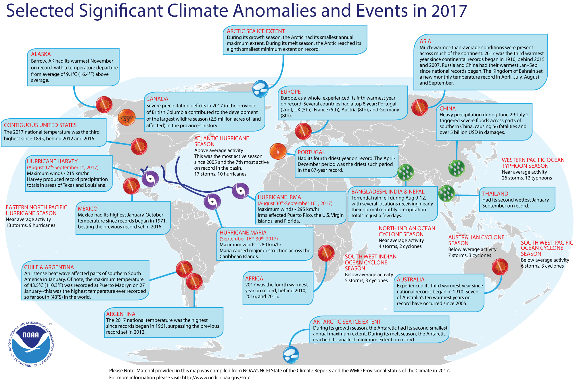
- Global weather and climate for 2017 reviewed -- Scientists at NOAA's National Centers for Environmental Information (NCEI) reported that based upon their preliminary analysis of worldwide land and ocean surface temperature data, the calendar year of 2017 was the third highest since sufficiently detailed world-wide climate records began in 1880, just behind the previous records set in the previous two years of 2016 and 2015. The average global temperature across land and ocean surface areas for 2017 was 1.51 Fahrenheit degrees (0.84 Celsius degrees) above the 20th century (1901-2000) average of 57.0 degrees Fahrenheit (13.9 degrees Celsius). For comparison, the highest global temperature departure was set in 2015 with a temperature anomaly (difference between annual and 20th-century average temperatures) of 1.69 Fahrenheit degrees, followed by the 2015 temperature anomaly of 1.62 Fahrenheit degrees. Both these record years were influenced by a strong El Niño episode involving anomalously high sea surface temperatures in the tropical Pacific Ocean. The year 2017 represents the warmest year without an El Niño present.
When considered separately, annually-averaged temperature for ocean surfaces in 2017 was 1.21 Fahrenheit degrees higher than the 20th century average, which was the third highest departure for ocean temperatures behind the record set in 2016. The 2017 land surface temperature was 2.36 Fahrenheit degrees above the 20th century average, which also was the third highest temperature over land since 1880.
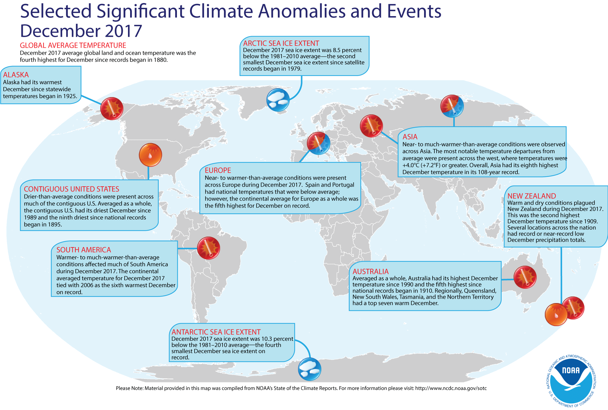
Furthermore, the combined global land and ocean average surface temperature departure from average for December 2017 was the fourth highest monthly December temperature in the 138-year record.
The Arctic sea ice remained well below the long-term averages that cover the period of record beginning in 1979 when satellite surveillance of the polar ice caps began. During the winter growth season, the sea ice covering the Arctic experienced its smallest annual maximum extent, while at the end of the summer melt season, the sea ice was the eight smallest minimum summer extent on record. Sea ice extent around Antarctica also was below average. During the winter growth season, the ice around that content reached the second smallest annual maximum extent for the satellite period, while during the summer melt season, the ice extent was the smallest minimum on record. [NOAA/NCEI State of the Climate]
NCEI also provides a map showing the Global Significant Weather and Climate Events map for 2017. A similar global extremes map is available for December 2017.
An animation produced by NCEI shows Earth's surface temperature for each year in the 1880-2017 period of record compared to the 1981-2010 average. [NOAA Climate.gov News]
Using a slightly different areal averaging technique on the near-surface air temperatures from essentially the same stations as used by NCEI, scientists at NASA's Goddard Institute for Space Studies (GISS) in New York City, determined that Earth's global surface air temperatures in 2017 were the second highest since 1880, ranking only behind the annual global air temperatures in 2016. (Note: NASA compares the annual global air temperatures with respect to the 1951 to 1980 means, while NCEI makes its comparisons with the 1901-2000 averages.) [NASA Press Release] In a joint news conference held last Thursday, the director of NASA GISS and the Chief of the Monitoring Branch of NCEI announced their findings that are summarized in graphical format on 15 slides.
[NASA/NOAA Press Briefing ]
Scientists at the United Kingdom's Met Office Hadley Centre and the University of East Anglia's Climatic Research Unit also maintain a long-term global temperature dataset and they noted that 2017 was the second or third warmest year for annual global temperatures since 1850. Furthermore, the noted that 2017 was the warmest year in their record without the aid of an El Niño event. [UK Met Office News]
- An All-Hazards Monitor -- This Web portal provides the user information from NOAA's National Weather Service, FAA and FEMA on
current environmental events that may pose as hazards such as tropical
weather, fire weather, marine weather, severe weather, drought and
floods. [NOAA/NWS Daily Briefing]
- Earthweek -- Diary of the Planet [earthweek.com]
Concept of the Week: Touring the
AMS Ocean Studies RealTime Ocean Portal
You are embarking on a study of
the world ocean and the role of the ocean in the Earth system. This
unique teacher enhancement course focuses on the flow and
transformations of energy and water into and out of the ocean, the
internal properties and circulation of the ocean, interactions between
the ocean and the other components of the Earth system, and the
human/societal impacts on and responses to those interactions.
Throughout this learning experience, you will be using the RealTime Ocean Portal to access and interpret a variety of
environmental information, including recent observational data. The
objective of this initial Concept of the Week is to
explore features of the RealTime Ocean Portal website.
On Monday of each week of the course, we will post the current Weekly Ocean News that includes Ocean in
the News (a summary listing of recent events related to the
ocean), Concept of the Week (an in-depth analysis
of some topic related to the ocean in the Earth system), and Historical
Events (a list of past events such as tsunamis or specific
advances in the understanding of oceanography). When appropriate, a
feature called Supplemental Information-In Greater Depth will be provided on some topic related to the principal theme of the
week.
You will use the RealTime Ocean Portal to
access and download the weekly "Current Ocean Studies" that complement Investigations found in your Ocean
Studies Investigations Manual. These materials should be
available Monday morning. Click the appropriate links to download and
print these electronic Current Ocean Studies and answer forms as well
as your Chapter Progress and Investigations Response forms.
The body of the RealTime Ocean Portal provides
links to the Earth System, information on Physical & Chemical,
Geological, and Biological aspects of the ocean, Atmosphere/Ocean
Interaction, the Great Lakes, and extras-a glossary of terms, maps and
educational links. Following each section is a link to other sites that
examine the various subsystems of the Earth system. Let's take a quick
tour to become more familiar with the RealTime Ocean Portal.
Under Physical & Chemical, click
on Sea
Surface Temperatures. This image uses a color scale
to depict the global pattern of sea surface temperatures (SSTs) (in
degrees Celsius) averaged over a recent 7-day period and based on
measurements by infrared sensors onboard Earth-orbiting satellites.
(Depending on your browser, you may have to place your mouse cursor on
the slide bar to the right and scroll down to view the entire image.)
Compare SSTs in the Northern Hemisphere with those in the Southern
Hemisphere. Return to the RealTime Ocean Portal.
Under Geological, click on Current
Earthquake Activity. The USGS Current World
Seismicity page provides a global map of the locations of seismic
(earthquake) events color-coded for the past seven days. The size of
the squares represents the magnitude of recent earthquakes. Note how
earthquakes are concentrated along the margin of the Pacific Ocean.
Details of recent earthquakes can be found by clicking on their map
squares. Return to the RealTime Ocean Portal.
The ocean is home to a wide variety of habitats and organisms.
Under Biological, click on Ocean
"Color" (Productivity). This is
a satellite-derived (SeaWiFS) color-coded map of biological
productivity in the surface waters of the world ocean is averaged from
October 1978 to date. Orange and red indicates the highest
productivity, while dark blue and violet indicate the lowest
productivity. Note the vast areas of relatively low productivity over
the central regions of the subtropical ocean basins. Individual months
within this period may be chosen for viewing. Now return to the RealTime Ocean Portal.
Under Atmosphere/Ocean Interaction, click
on TRMM/GPM
Tropical Rainfall. The TRMM/GPM (Tropical
Rainfall Measuring Mission) page includes color-coded maps of
the Monthly Mean Rainrate (in mm per day) across the tropics for the
last 30 days ending on the present date. Changes in rainfall are linked
to large-scale shifts in the atmosphere/ocean circulation in the
tropics. Now return to the RealTime Ocean Portal.
Take a few minutes when you have time to browse the other data
and information sources available via the RealTime Ocean Portal. Return frequently to learn more about the many resources on
the ocean in the Earth system. Bon voyage!
Historical Events
- 23 January 1622...William Baffin, the English explorer who
sought the Northwest Passage as a route around the northern coast of
North America, died at an estimated age of 38 during the war between
the Shah of Persian and the Portuguese. In 1615, he explored what is
now known as Baffin Bay, coming within 800 miles of the North Pole. His
voyages were made with scientific care, determining latitudes, and
observing tides. With records made of his compass needle, he made the
first magnetic chart. He was the first to attempt a determination of
longitude by observing the moon. (Today in Science History)
- 23 January 1960... The Trieste, a specially constructed submersible bathyscaphe, descended to a
depth of 35,810 feet in the Pacific Ocean called the Challenger Deep,
the deepest point known to exist on Earth, in the Marianas Trench near
Guam. (Today in Science History)
-
26 January 1700...The Cascadia Earthquake (magnitude 9) took place off the coast of British Columbia, as evidenced by Japanese records. Landslides and a tsunami destroyed many Native American villages along the coasts of Washington, Oregon and British Columbia, including Vancouver Island. Japanese written history tells of a massive tsunami striking fishing villages the next day along the coast of Honshu, killing hundreds. (Wikipedia) (Today in Science History)
- 26 January 1983...The California coast was battered by a storm, which produced record high tides, thirty-two-foot waves, and mudslides, causing millions of dollars in damage. The storm then moved east and dumped four feet of snow on Lake Tahoe. (22nd-29th) (The Weather Channel)
- 28 January 1946...Canada's greatest sailing ship, Bluenose,
foundered on a Haitian reef; all hands were saved. Her likeness remains
on the Canadian ten-cent coin. (Wikipedia)
- 28 January 1969...A series of storms that battered Southern
California from the 18th to the 28th led to $125 million damage in the Los Angeles Basin, along with
approximately 9 storm and traffic-related deaths in California. Twenty
feet of water covered Sherman Island, a region that contains more than
10,000 dike-protected agricultural acres, when a dike failed. (Accord's
Weather Guide Calendar)
- 28 January 1971...A waterspout swept into Hawaii's Kailua
Bay, then into the business and hotel district of Kailua-Kona,
destroying or severely damaging a number of buildings including 40
apartment units and collapsing a 6-story hotel under construction.
Amazingly, only four people were injured. (Accord's Weather Guide
Calendar)
Return to RealTime Ocean Portal
Prepared by DS Ocean Central Staff and Edward J. Hopkins,
Ph.D.,
email hopkins@aos.wisc.edu
© Copyright, 2018, The American Meteorological Society.