WEEKLY OCEAN NEWS
22-26 December 2014
DataStreme Ocean will return for Spring 2015 with new
Investigations
files starting during Preview Week, Monday, 19 January 2015. All the
current online website products, including updated issues of Weekly
Ocean News, will continue to be available throughout the
winter break period.
Happy Holidays to
everyone!
Sincerely,
Ed Hopkins and the AMS DS Ocean Central Staff
Items of Interest:
- Holiday lights seen from space -- Scientists at NASA's Goddard Space Flight Center recently released satellite images and a report detailing how holiday lights in various cities around the United States are emitting increased light intensity that is detectable by the Visible Infrared Imaging Radiometer Suite sensor onboard the NASA/NOAA Suomi NPP satellite. The nighttime images clearly indicate brighter and more intense light emanating from several metropolitan areas in the Middle Atlantic States and in southern California beginning by Black Friday (after Thanksgiving) and continuing through New Years Day In addition, several cities in the Middle East had increased illumination during the holy month of Ramadan. [NASA Goddard Space Flight Center ]
- Dreaming of a White Christmas -- NOAA's National Climatic Data Center produced a national map showing the climatological probability (in percent) that a snow depth of at least one inch would be observed on the morning of 25 December based upon the 1981-2010 standard 30-year climatological reference interval. This map shows the ratio of the number of times that a particular station experienced a white Christmas during the interval as a probability. For example, Des Moines, IA had only 12 Christmases between 1981 and 2010 when an inch or more snow cover was observed, so the probability that residents of Iowa's capital city would have a white Christmas is 40%. Some locations across the nation are almost certain to have a white Christmas, generally along the Canadian border surrounding the Great Lakes, such as Marquette, MI (with 93%) and in New England, such as at Caribou, ME (87%). Stations at higher elevations in the Rockies also have a higher probability, such as at Flagstaff, AZ with a 65%. Sites close to the oceans typically have a lower probability, as the oceans tend to be relatively warm at this time of year. Santa typically finds tough sledding on his journey to that half of the country south of latitude 40 degrees that is not mountainous, where chances of a white Christmas fall from 50% to 20% or less. You can monitor the current snow cover across North America using a snow chart that is based upon satellite data.
- Climatology of Southeast NCAA bowl games updated -- The Southeast Regional Climate Center has provided a listing of the weather history for fifteen NCAA college bowl games that are to be played within the next two weeks across the Southeastern States. This climatology includes the warmest, coldest, wettest and snowiest days in the particular bowl's history.
- Student scholarships announced -- The NOAA Office of Education recently announced that scholarships are available to undergraduate and graduate students who are majoring in the atmospheric and oceanic sciences, along with several of the other scientific and technical disciplines that support NOAA's mission and programs. [NOAA Office of Education] These scholarships include:
- Educational Partnership Program (EPP) Undergraduate Scholarship: http://www.epp.noaa.gov/ssp_undergrad_page.html. This program provides an opportunity for rising junior students to study disciplines relating to the NOAA's mission. Students attending Minority Serving Institutions are encouraged to apply. The application deadline for the 2015 EPP Undergraduate Scholarship Program is 31 January 2015.
- Ernest F. Hollings Undergraduate Scholarship Program: http://www.oesd.noaa.gov/scholarships/hollings.html#page=timeline. This program is designed to: (1). increase undergraduate training in oceanic and atmospheric science, research, technology, and education and foster multidisciplinary training opportunities; (2) increase public understanding and support for stewardship of the ocean and atmosphere and improve environmental literacy; (3.) recruit and prepare students for public service careers with NOAA and other natural resource and science agencies at the federal, state and local levels of government; and (4.) recruit and prepare students for careers as teachers and educators in oceanic and atmospheric science and to improve scientific and environmental education in the United States. The application deadline for the 2015 Ernest F. Hollings Undergraduate Scholarship Program is 30 January 2015.
Ocean in the News:
- Eye on the tropics --- During the last week, no organized tropical cyclone
activity was found across any of the world's ocean basins in either the Northern or Southern Hemispheres.
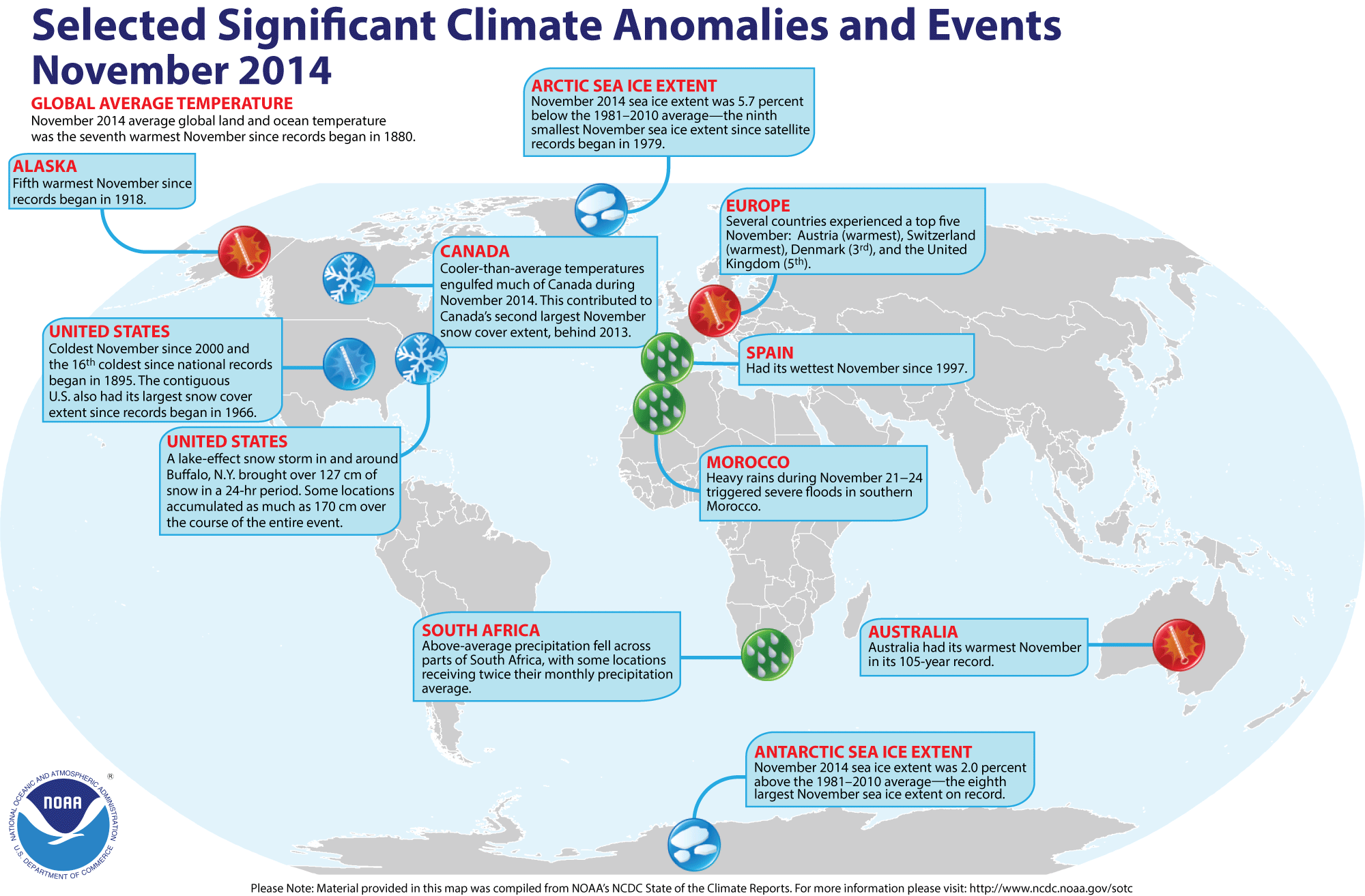
- A global review of November 2014 temperatures -- Preliminary
analysis of temperature data by scientists at NOAA's National Climatic
Data Center indicates that the worldwide combined ocean and land
surface temperature for November 2014 tied the temperature for November 2008 for the seventh highest
global November surface temperature since a sufficiently dense and
reliable network began in 1880. This combined global temperature was approximately 1.2 Fahrenheit degrees above the 20th century (1901-2000) average November temperature. They also found that the global land surface temperatures was the thirteenth highest temperature reading for any November on record, while the global
ocean surface temperature was the highest since 1880. Furthermore, they
reported that the combined land and ocean surface temperature for the
globe during the Northern Hemisphere autumn (September-November 2014)
was the highest for all boreal autumn seasons on record. The global ocean temperature for these three months was also a record high value for the 135-year period of record, while the corresponding global land temperature was the ninth highest on record. The record warm ocean waters in the tropics suggests the possibility of a weak El Niño event developing during Northern Hemisphere winter (December through February). [NOAA/NCDC
State of the Climate]
A global map of Selected Significant Climate Anomalies and Events for November 2014 is available from NCDC.
According to satellite data collected by National Snow and Ice Data Center, the sea ice over the Arctic Ocean during November 2014 had the ninth smallest areal extent for any November since satellite-derived ice records began in 1979. However, the sea ice around Antarctica was the eighth largest November ice extent on record. [NOAA/NCDC Global Snow & Ice]
- World magnetic model is updated -- Earlier last week NOAA officials announced an update to the "World Magnetic Model" (WMM), a large-scale representation of the Earth's magnetic field that involves showing the differences between magnetic compass directions and geographic (or true) North. This model, which was updated by NOAA and the British Geological Survey, is used to ensure accurate navigation and it complements GPS devices used by for military purposes by NATO, the United States and the United Kingdom, along with civilian applications ranging from mineral exploration to smartphone apps. Updates are needed because the position of the Earth's magnetic field continually changes with time. [NOAA News]
- Annual Arctic Report Card released -- Last
week, NOAA's Climate Program Office released its 2014 annual update of
the "Arctic Report Card," a peer-reviewed report of the state of the
air, ocean and ice in the Arctic basin prepared by an international
team of 63 scientists from 13 countries, including those from NOAA.
These experts have found air and water temperatures across the Arctic continued to increase, with Arctic air temperatures increasing at rates more than double the rate of global air temperature increase. Furthermore, the reflectivity of the surface of the Greenland ice sheet was reduced along with shrinkages in the spring snow cover on land and summer ice on the oceans. The general health and numbers of polar bear populations were also observed to decline. [NOAA
News]
Data collected from sensors onboard NASA satellites show a marked increase in the solar radiation absorbed across the Arctic basin since 2000. Measurements made by NASA's Clouds and the Earth's Radiant Energy System (CERES) instruments show the rate of absorbed solar radiation in the Arctic in June, July and August has increased by five percent. [NASA Earth Observatory] The decline in the regional surface reflectivity or albedo is due in part to large expanses of open water in summer, which would enhance warming of the region. Maps of trends of absorbed radiation and sea ice fractions between 2000 and 2014 are provided. [NASA Earth Observatory]
- Funding call issued for Gulf projects -- During this past week the NOAA RESTORE Act Science Program issued a call for proposals designed for environmental observations and long term studies in the Gulf of Mexico is one of the areas the NOAA RESTORE Act is focusing on in this first grant competition. The funding competition would involve up to $2.5 million in grant support. [NOAA News]
- Recommendations issued to combat illegal and unreported fishing -- Early last week the Presidential Task Force on Illegal, Unreported, and Unregulated (IUU) Fishing and Seafood Fraud, co-chaired by the US Departments of State and Commerce, released its recommendations to the President for a comprehensive framework to combat IUU fishing and seafood fraud. These recommendations include those involving international cooperation, strengthened enforcement tools, creation and expansion of partnerships between various levels of government, industry and other organizations and the creation of a risk-based traceability program. [NOAA News]
- "Tipping points" for flooding due to sea-level rise are established -- A team of NOAA scientists recently published a paper entitled "From the Extreme to the Mean: Acceleration and Tipping Points for Coastal Inundation due to Sea Level Rise" that establishes "tipping points" for flooding of the nation's coastal areas due to projected sea-level rise. According to this report, most of US coast may experience these "tipping points" of 30 or more days per year of floods that would be as much as two feet above high tides by 2050. [NOAA News]
- Maps of atmospheric carbon dioxide concentrations obtained from new satellite -- Some of the first global maps of the geographic distribution of atmospheric carbon dioxide obtained over a nearly six-week interval from early October through mid November 2014 from NASA's new Orbiting Carbon Observatory-2 (OCO-2) spacecraft. This OCO-2 spacecraft was launched into a sun-synchronous orbit around the Earth in early July 2014 by NASA to study the carbon dioxide concentrations in the atmosphere, including the "sources" and "sinks" of this greenhouse gas. Another map from OCO-2 shows solar-induced fluorescence, a plant process that occurs during photosynthesis, collected from August through October 2014, during spring (autumn) in the Southern (Northern) Hemisphere. [NASA Jet Propulsion Laboratory]
- Seeing Earth from the Terra satellite for 15 years -- Fifteen years ago last week NASA launched its Terra spacecraft, a polar orbiting satellite that would be part of the agency's Earth Observing System. A collage has been produced of 15 impressive satellite images obtained from NASA's fleet of satellites that include Terra, Aqua and Aura. [NASA Goddard Space Flight Center]
- UK Met Office global average temperature forecast made for 2015 -- Last week, scientists at the United Kingdom's Meteorological Office (Met Office) released their annual global temperature forecast for the upcoming year of 2015. They anticipate the global average temperature in 2015 to be 0.64 Celsius degrees above the long-term (1961-1990) average of 14.0 degrees Celsius, with a range of uncertainty extending from 0.52 to 0.76 Celsius degrees around the central estimate. Therefore, 2015 could be one of the warmest years since comprehensive global climate records began in 1880. Using observational data running through October 2014, the scientists also noted that this current year's global temperature has a central estimate of 0.57 Celsius degrees above the 1961-1990 average. These preliminary statistics for 2014 essentially is the same as the forecast made by the Met Office in December 2013. Furthermore, the temperature for the first ten months of the year suggests that 2014 would rank as one of the warmest years dating back to 1880. [Editor's note: The statistics involved with the global temperature record are from the three main global temperature datasets compiled by: The Met Office and University of East Anglia (HadCRUT4); NOAA National Climatic Data Center (NOAA NCDC) and NASA Goddard Institute of Space Studies (NASA GISS). The Met Office uses the 1961-1990 interval for long-term averages that is accepted by the World Meteorological Organization (WMO), rather than the 1981-2010 interval currently used by NCDC. EJH [UK Met Office News]
- An All-Hazards Monitor -- This Web portal provides the user information from NOAA's National Weather Service, FAA and FEMA on
current environmental events that may pose as hazards such as tropical
weather, fire weather, marine weather, severe weather, drought and
floods. [NOAA/NWS Daily Briefing]
- Earthweek -- Diary of the Planet [earthweek.com] Requires Adobe Acrobat Reader.

Historical Events:
- 22 December 1832...The HMS Beagle and
Charles Darwin reached the Barnevelts Islands
- 22 December 1837...Congress authorized the President "to
cause any suitable number of public vessels, adapted to the purpose, to
cruise upon the coast, in the severe portion of the season, and to
afford aid to distressed navigators." This statute was the first
authorizing activities in the field of maritime safety, thereby
interjecting the national government into the field of lifesaving for
the first time. Although revenue cutters were specifically mentioned,
the performance of this duty was imposed primarily upon the Revenue
Marine Service and quickly became one of its major activities. (USCG
Historian's Office)
- 22 December 1894...The Dutch coast was hit by a hurricane.
- 23 December 1811...A cold storm hit Long Island Sound with
a foot of snow, gale force winds, and temperatures near zero. During
the storm, many ships were wrecked, and in some cases, entire crews
perished. (David Ludlum)
- 23 December 1854...A tsunami struck the coast of Japan,
with water in the harbor of Simoda changing depth between 8 and 40
feet. Twelve hours later this giant wave reached the Pacific coast of
the U.S. The newly installed self-registering tide gauges noted these
waves. The information derived from this event enabled Alexander D.
Bache, Superintendent of the U.S. Coast and Geodetic Survey, to apply a
newly derived law relating ocean depth to wave speed and provide the
first relatively accurate scientific estimate of the depth of an ocean
between Japan and the Pacific coast of the U.S. The velocity of the sea
wave from Simoda to San Francisco was 369 mph. (Today in Science
History)
- 25 December 1492...The Santa Maria, one
of the ships that Christopher Columbus used in his historic
trans-Atlantic voyage, landed at the Dominican Republic.
- 25 December 1974...Tropical Cyclone Tracy (a hurricane in
the waters surrounding Australia) made landfall near Darwin, Northern
Territory, Australia. Excellent warnings kept the death toll to between
50 and 60, with more than 20,000 people evacuated in the week following
the storm. Some areas were totally devastated. Peak wind speeds reached
exceeded 174 mph. (The Weather Doctor) (Accord's Weather Calendar)
- 26-31 December 1993...The Sydney to Hobart Yacht Race off
Australia was plagued by hurricane-force wind gusts in excess of 74 mph
and 33 foot high seas. Of 104 starters, only 37 yachts finished the
race. On the 28th, one yacht owner spent five
hours in the water after being swept overboard. (Accord's Weather
Calendar)
- 26 December 2004...A massive earthquake measuring 9.0 on
the Richter magnitude scale approximately 100 miles off the western
coast of Sumatra created a tsunami that caused devastation in Sri
Lanka, India, Indonesia, Thailand, Malaysia, The Maldives and many
other areas around the rim of the Indian Ocean. The death toll is
currently estimated at more than 300,000. Officials say the true toll
may never be known, due to rapid burials. Indonesia was worst affected
with as many as 219,000 people killed. (Wikipedia)
- 28 December 1857...The light was first illuminated in the
Cape Flattery Lighthouse, located on Washington State's Tatoosh Island
at the entrance to the Strait of Juan de Fuca. "Because of Indian
trouble it was necessary to build a blockhouse on Tatoosh Island before
even commencing the construction of the lighthouse. Twenty muskets were
stored in the blockhouse, and then the lighthouse work began." (USCG
Historian's Office)
- 28 December 1903...An Executive Order extended the
jurisdiction of the Lighthouse Service to the non-contiguous territory
of the Hawaiian Islands. (USCG Historian's Office)
- 28 December 1908...An early morning earthquake under the
Straits of Messina leveled cities in Sicily and southern mainland
Italy, as well as producing a tsunami with 40-foot waves that inundated
coastal communities. This earthquake, estimated to by a magnitude 7.5
on the Richter scale, and the resulting tsunami killed an estimated
100,000 people. Long stretches of coastline sunk into the Messina
Straits and disappeared from view. A steady rain also added to the woes
of the survivors. (The History Channel)
Return to DataStreme
Ocean Website
Prepared by AMS DS Ocean Central Staff and Edward J. Hopkins,
Ph.D., email hopkins@meteor.wisc.edu
© Copyright, 2014, The American Meteorological Society.