WEEKLY CLIMATE NEWS
23-27 July 2018
ITEMS
OF INTEREST
- Peak in the annual temperature curves -- This week represents the fourth full week of July, which for many locations across the nation are experiencing their warmest week of the year, as indicated by the daily normal high and low temperatures. Usually, those stations located away from the moderating influences of the oceans reach their highest temperatures during the third to fourth week of July, or a roughly one month after the summer solstice, when the Northern Hemisphere receives the most hours of daylight and the largest amounts of solar radiation. During July, temperatures continue to rise to their highest typical values as radiational heating continues. However, the length of daylight and the amount of sunshine during this month begin decrease and the normal daily temperatures will begin to fall toward their lowest levels in mid to late January. Comparison is invited with the "Warmest Day of the Year" maps generated for the nation by NOAA's National Centers for Environmental Information for the 1981-2010 normals interval.
- Zenithal Sun -- Residents of Hawaii's Big Island are experiencing a noontime sun that would be directly overhead during this past weekend and the start of this week (22-23 July). This occurrence of a zenithal sun is one of the two times during the year when the noontime sun is directly overhead to residents of Hilo and elsewhere on the Big Island. The other time when the Big Island experienced a zenithal sun was in mid May [US Naval Observatory, Data Services]
- July full moon and a long total lunar eclipse -- The moon will reach full moon phase this Friday afternoon (officially, 2020Z on 27 July 2018, or equivalently, 4:20 PM EDT and 3:20 PM CDT, etc.). The July full moon is called the "Thunder" or "Hay Moon."
At the time of this full moon, a total lunar eclipse will occur as the moon passes through the penumbra (lighter portion of the Earth's shadow) and the umbra (darker portion of the shadow). The time of greatest eclipse will be at 2021Z (4:21 PM EDT) Friday. This total lunar eclipse will be primarily an Eastern Hemisphere event, as it should be visible across nearly the entire Atlantic Ocean basin, including all of South America along with large sections of Europe, Africa, North America. Residents in North America will not be able to witness this eclipse. A figure on the NASA Eclipse Web Site shows the particulars of this eclipse.
Because of geometric considerations, this lunar eclipse will last 1 hour and 43 minutes, making it the longest lunar eclipse of the entire 21st century. The eclipse will be the century's longest since the moon will pass through the center of the cone representing the Earth's shadow and the eclipse will be occurring approximately 14 hours after lunar apogee (farthest Earth-moon distance), thereby reducing the apparent size of the lunar disk and increasing the length of time the moon travels in that portion of its elliptical orbit. In addition, this event can be called a "blood moon eclipse" since the lunar disk will appear to turn an impressive red or ruddy-brown color. This coloration is due to the filtering of a small amount of sunlight passing around the obscuring planet by the Earth's atmosphere, leaving only reddish colors reaching the lunar surface. [Space.com]
CURRENT
CLIMATE STATUS
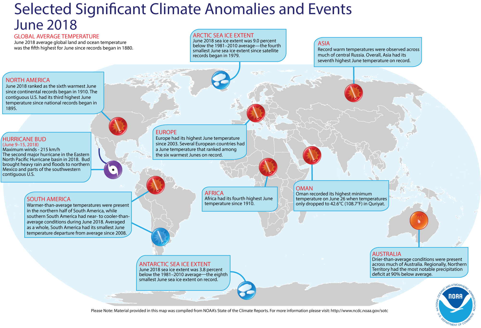
- Global temperature and ice cover for June 2018 reviewed -- Scientists at the NOAA National Centers for Environmental Information (NCEI)
recently reported on their analysis of preliminary weather data collected during the month of June 2018:
- The combined global land and ocean surface temperature for June 2018 was 1.35 Fahrenheit degrees above the 20th
century (1901-2000) average, which was the fifth highest temperature for any month of June since sufficiently detailed global climate records
began in 1880.
When considered separately, the average ocean temperatures for June 2018 was the sixth highest for
any June, while the average land surface temperature for this past month also was the sixth highest June land temperature during the 139-year record.
Furthermore, the average combined land-ocean temperature through the first six months of the year (January through June 2018) was the fourth highest for the first half of any year since 1880.
- The researchers at the National Snow and Ice Data Center noted the areal extent of the Arctic sea ice for June 2018 was the fourth smallest for the month since satellite surveillance began in 1979. In addition, the extent of the Antarctic sea ice was the eighth smallest in the 40-year record. [NOAA/NCEI
State of the Climate]
A global map of Selected Significant Climate Anomalies and Events for June 2018 is available from NCEI.
Using their own techniques to analyze the ground-based observations and satellite data to obtain a spatial average temperature, scientists at NASA's Goddard Institute for Space Studies (GISS) noted that the global composite temperature for June 2018, which tied June 1998 for the third-highest June monthly temperature since 1880. (NOTE: The temperature anomalies, or arithmetic differences between current observed and a long-term average is based upon the 1951-1980 averaging interval, which differs from the 1901-2000 interval used by NCEI. EJH) [NASA Global Climate Change Feature]
- Saharan dust stretches westward across tropical Atlantic this summer -- A meteorologist at NOAA's Climate Prediction Center wrote an "Event Tracker" blog for the ClimateWatch Magazine discussing the impacts of the large amounts of dust from Africa's Sahara Desert that were carried westward across the tropical Atlantic Ocean since late June. Some of the dust reached the Gulf of Mexico and the southern U.S. An animated sequence of seven natural-color satellite images obtained from the sensors onboard the NASA/NOAA Suomi NPP satellite during the span 6-12 July 2018 shows the tan-colored dust cloud from off the Sahara Desert being carried across the dark blue waters of the Atlantic to the Caribbean. He noted that the dust resulted in colorful sunsets, poor air quality in the southern U.S. and a suppression of tropical cyclone activity across the Atlantic basin during the first month of the basin's 2018 hurricane season. Furthermore, the Saharan dust provides mineral nutrients for phytoplankton in the ocean and helps fertilize South America's Amazon rainforests. Noting that these dust cloud events are not all that uncommon, he explains that the mineral dust often comes from the Bodélé depression, the lowest point in Chad, where dust storms occur as many as 100 days per year.
[NOAA Climate.gov News]
- Large iceberg in Weddell Sea moves only a short distance in one year -- False-color images of Iceberg A-68 acquired nearly one year apart from the Thermal Infrared Sensor (TIRS) on NASA's Landsat 8 show that this iceberg has moved a relatively short distance across Antarctica's Weddell Sea between the end of July 2017 and the start of July 2018. Iceberg A-68 broke away from the Larsen C Ice Shelf on the Antarctic Peninsula in July 2017. [NASA Earth Observatory]
CURRENT
CLIMATE MONITORING
- Survey of world's beaches reveals threats to protected areas -- A team of engineers and scientists from the Netherlands developed a computer software scheme that permitted the rapid identification of the world's sandy beaches from 30 years of data obtained from the NASA/U.S. Geological Survey's Landsat satellites. The recently completed survey indicates that nearly one third (31 percent) of all ice-free shorelines are sandy or gravelly. The survey also indicates a slight increase in the world's sandy beaches over the past three decades, but a decrease was found in protected marine areas, where erosion was occurring. Approximately 24 percent of Earth's sandy beaches are eroding, representing a coastline distance of nearly 50,000 miles. The team claims that their research could help determine how the beaches and the associated ecosystems would respond to natural environmental changes and to the impacts due to human activity. [NASA Global Climate Change News]
CLIMATE FORECASTS
- New Seasonal Climate Outlooks for late summer
and early fall issued -- Near the end of last week, forecasters at the NOAA
Climate Prediction Center (CPC) released their new national Three-Month
(Seasonal) Climate Outlooks for August through October 2018, corresponding to the last month
of meteorological summer season (in the Northern Hemisphere)
and the first two months of meteorological autumn. (September and October). Specific details of
their outlooks include:
- Temperature and precipitation outlooks -- According to their temperature
outlook, over 90 percent of the 48 contiguous United States, along with all of Alaska should experience a high chance of above average temperatures
for these three upcoming months. The forecasters express their highest confidence in their forecasts for sections of the Intermountain West, extending from eastern Washington southward to the Four Corners (Arizona, Colorado, New Mexico and Utah), as well as across the Northeast, centered on eastern New England. Since no clear signal was expected across the northern Plains and Upper Midwest, this region was given an Equal Chance of having either above or below average temperatures through the following three months.
Their precipitation
outlook calls for better than even chances of dry conditions
for late summer and early autumn of 2018 across the Pacific Northwest, centered upon Washington's Olympic Peninsula, as well as across the lower Mississippi Valley, the Ozark Plateau and the southern Plains. Conversely, sections of the Great Basin and the Four Corners area, together with the coastal regions of the Carolinas, Georgia and the northern Florida Peninsula should have better than chance of above average precipitation. The rest of the 48 contiguous states should have equal chances of below and above average summer precipitation. Most of mainland Alaska should also have a good chance of wetter than average conditions during these next three months. The southeastern Panhandle could expect below average precipitation, while the Alaska Peninsula in the southwestern sections of the state was given equal chances of below or above average precipitation.
A summary of the prognostic discussion of the 3-month outlook for non-technical users is available from CPC. These forecasts were based upon how changes in atmospheric and oceanic circulation appear to suggest development of El Niño conditions by boreal autumn. The various prediction models available to the forecasters also point to this transition to El Niño conditions through the remainder of the year. A description is also provided as how to read these 3-class, 3-month Outlook maps.
- Seasonal Drought Outlook -- The forecasters at NOAA's Climate Prediction Center also released their US
Seasonal Drought Outlook last week that would run from late-July through October 2018. Their outlook would call for the persistence of current drought conditions or for the expansion of drought conditions across the West Coast States (California, Oregon and Washington), sections of the Great Basin in Nevada, the interior Northwest in Montana and across a wide section of the southern Rockies, the southern Plains and the lower Mississippi Valley, extending from Texas northward into Kansas, Oklahoma, Missouri and western Illinois. Sections of the Southwest centered upon the Four Corners States and New England could experience some improvement in drought conditions, including their removal from drought conditions.
Note: a Seasonal
Drought Outlook Discussion is included describing the
forecasters' confidence.
CLIMATE
AND HUMAN HEALTH
- International action taken on dust and sandstorms -- A high-level General Assembly meeting of the United Nations (UN) was held early last week to examine the various risks to humans that are posed by sand and dust storms around the world. The UN's World Meteorological Organization (WMO) reported that more than 150 countries are directly or indirectly affected by sand and dust storms, which adversely impact human health, the environment, agriculture and transport. WMO action to improve sand and dust storm forecasts and warnings was also outlined. [WMO News]
CLIMATE
AND SOCIETY
Historical Events:
- 23 July 1923...Sheridan, WY was drenched with 4.41 inches of rain, an all-time 24-hour record for that location. (22nd-23rd) (The Weather Channel)
- 23 July 1987...Thunderstorms produced a record ten inches of rain in six and a half-hours at Minneapolis, MN, including 5.26 inches in two hours. Flash flooding claimed two lives and caused 21.3 million dollars damage. Streets in Minneapolis became rushing rivers, parking lots became lakes, and storm sewers spouted like geysers. A tornado hit Maple Grove, MN causing five million dollars damage. Baseball size hail was reported at Olivia, MN. (The National Weather Summary) (Storm Data)
- 23 July 2010...The largest (by diameter) and heaviest hailstone on record in the United States fell on Vivian, SD. The stone was 8 inches in diameter and weighed 1.9 pounds. The person who found the stone reported that some melting had occurred before the official measurement was taken. This hailstone broke the previous US record for diameter (7.0 inches - 22 June 2003 in Aurora, NE) and weight (1.67 pounds - 3 September 1970 in Coffeyville, KS). The Aurora, NE hailstone will retain the record for circumference (18.75 inches). Several other stones of 6 inches or more in diameter were measured during the storm survey. (National Weather Service files)
- 23 July 2011...Chicago, IL set an all-time daily record rainfall when 6.86 inches fell during the early morning hours of Saturday, 23 July 2011, at O'Hare airport. The previous daily record was 6.64 inches set on 13 September 2008. (National Weather Service files)
- 24 July 1928...Wahluke, WA hit a high temperature of 118 degrees, which tied a record high for the state. In August 1961, this all-time state record high was tied at Ice Harbor Dam. (Intellicast)
- 24 July 1936...Record high temperature for Kansas was tied at 121 degrees near Alton. The record high for Nebraska was also tied at Minden with 118 degrees.
- 24 July 1942...The temperature at Las Vegas, NV hit 117 degrees to set an all- time record for that location. (The Weather Channel)
- 24 July 1952...The temperature at Louisville, GA soared to 112 degrees to establish a state record. This record for the Peach State was tied in August 1983. (The Weather Channel) (NCDC)
- 24-25 July 1979...Claudette, a weak tropical storm, deluged southeastern Texas with torrential rains. The Houston suburb of Alvin received 43.00 inches, a 24-hour precipitation record for not only the Lone Star State, but for the U.S. Freeport reported a total of 30 inches. Total damage from flooding was over $400 million. (Intellicast) (David Ludlum) (NCDC) (Accord's Weather Guide Calendar)
- 25 July 1979...Tropical Storm Claudette produced phenomenal rainfall totals in southeast Texas. Thirty to forty inches fell in 24 hours around Alvin. Freeport reported a total of 30 inches. Total damage from flooding was over $400 million. (Intellicast)
- 25 July 1987...Sixteen cities in the eastern U.S. reported record high temperatures for the date. Beckley, WV equaled their all-time record high of 91 degrees, established just the previous day. It marked their fourth day in a row of 90-degree heat, after hitting 90 degrees just twice in the previous 25 years of records. The water temperature of Lake Erie at Buffalo, NY reached 79 degrees, the warmest reading in 52 years of records. (The National Weather Summary)
- 26 July 1943...Tishomingo, OK baked in the heat as the mercury soared to 121 degrees, a Sooner State record high temperature. (The Weather Channel)
- 26 July 1960...The temperature at Salt Lake City, UT hit 107 degrees, an all-time record high for that location. (The Weather Channel)
- 26 July 1979...The U.S. record for 24-hour rainfall was set at Alvin, TX, with exactly 45 inches, thanks to Tropical Storm Claudette. (National Weather Service files)
- 27 July 1897...Jewell, MD received 14.75 inches of rain, which was a 24-hour rainfall record for Maryland. (NCDC)
- 27 July 1939...The temperature at Lewiston, ID hit 117 degrees to establish an all-time record high for that location. (The Weather Channel)
- 27-28 July 1984...Unprecedented rainfall fell at Alvsbyn in Sweden (approximately 62 miles south of the Arctic Circle), which was remarkable for such a northern location that is at about the same latitude as Fort Yukon, AK. On the 26th, 5.51 inches fell and on the 27th, an additional 5.63 inches were recorded. (Accord's Weather Guide Calendar)
- 27 July 1989...Thunderstorms produced locally heavy rains in the southwestern U.S. Yuma, AZ experienced their most severe thunderstorm of record. Strong thunderstorm winds, with unofficial gusts as high as 95 mph, reduced visibility to near zero in blowing dust and sand. Yuma got nearly as much rain in one hour as is normally received in an entire year. The storm total of 2.55 inches of rain was a record 24-hour total for July. Property damage due to flash flooding and high winds was in the millions. (Storm Data)
- 28 July 1930...The temperature at Greensburg, KY soared to 114 degrees to set a state record. (The Weather Channel)
- 28 July 1934...The temperature at Orofino, ID climbed to 118 degrees to establish a record for Idaho. (The Weather Channel)
- 28 July 1995...Yuma, AZ reached its all-time high temperature reading with 124 degrees. (Intellicast)
- 29 July 1898...The temperature at Prineville, OR soared to 119 degrees to establish a state record, which was tied on the 10th of August of that same year at Pendleton. (The Weather Channel)
- 29 July 1930...Mississippi's record high temperature of 115 degrees was set at Holly Springs. (Intellicast)
- 29 July 1958...The U.S. Congress passed legislation establishing the National Aeronautics and Space Administration (NASA), a civilian agency responsible for coordinating America's activities in space. (National Weather Service files)
Return to RealTime Climate Portal
Prepared by Edward J. Hopkins, Ph.D., email hopkins@aos.wisc.edu
© Copyright, 2018, The American Meteorological Society.