WEEKLY CLIMATE NEWS
23-27 April
2018
ITEMS OF
INTEREST
- Celebrating National Arbor Day -- This coming Friday, 27 April 2018, many locations across
the nation will celebrate Arbor Day, a day when the planting of trees
is encouraged. Arbor Day was originally proposed in 1872 by J. Sterling
Morton, Nebraska's first newspaper editor, and continues to be most
often celebrated by individual states on the last Friday in April.
However, since planting conditions vary greatly due to the state's
climate it may occur from September to May. In Arkansas, Arbor Day is
celebrated on the third Monday in March, but in Alaska, the date is the
third Monday in May. For your state's observance (and name of the
official state tree), please consult the National Arbor Day
Foundation.
- National Science Bowl set for next weekend -- The
US Department of Energy (DOE) National Science Bowl®, a nationwide
academic competition for middle and high school students will be held
through next weekend (26- 30 April 2018) in Washington, DC. This event
will test students' knowledge in all areas of science and is meant to
encourage high school students to excel in science and math and to
pursue careers in those fields. [DOE Office of Science]
- State, national and global instrumental records
-- Temperature and precipitation data have been collected
around the world since the mid-19th century. Beginning in the 1890s, a
sufficiently dense climate network has been established in the United
States and its territories. The records from around the nation and from
around the global have been collected and archived at several central
locations, such as NOAA's National Climatic Data Center (NCDC).
Scientists at NCDC along with colleagues at NASA's Goddard Institute
for Space Studies and in the United Kingdom have produced time series
of area-average monthly and annual temperatures for over a century on
state, national and global space scales. For more details on these
records and how to access them, please read this week's Supplemental Information...In Greater Depth.
CURRENT
CLIMATE STATUS
- Exceptional drought conditions expand across several states in the Southwest -- An animated sequence of maps depicting drought conditions across the contiguous United States beginning in mid-January 2018 and ending at the start of last week shows the relatively rapid expansion of "exceptional drought" conditions across a large swath of the Southwest, running from the Panhandles of Texas and Oklahoma westward to the Four Corners area (where Arizona, Colorado, New Mexico and Utah meet). "Exceptional drought", the most intense level of drought according to the National Drought Monitor, is responsible for widespread crop/pasture losses; shortages of water in reservoirs, streams, and wells, which create water emergencies. The animation showed that "extreme drought" (the next lower drought classification level) was found across sections of Oklahoma in mid-January, but during subsequent months, the region of extreme drought expanded westward, with a region of exceptional drought appearing across the Oklahoma and Texas Panhandles in March and April, to include sections of seven states. [NOAA Climate.gov News]
- Record low winter sea ice in Alaska's Bering Strait creates problems for coastal communities -- During the last week, the International Arctic Research Center at the University of Alaska Fairbanks produced a four-page summary of the winter 2018 sea ice conditions in and around the Bering Strait off Alaska's western coast. The amount of sea ice in the Bering Sea was the lowest since 1850, the result of unusual winter conditions that have prevailed in the region, involving above average air and water temperatures and more frequent storms with an increased frequency of winds from the south. The lack of persistent sea ice this winter caused a variety of problems for coastal communities. [NOAA Climate.gov News] or [University of Alaska Fairbanks International Arctic Research Center]
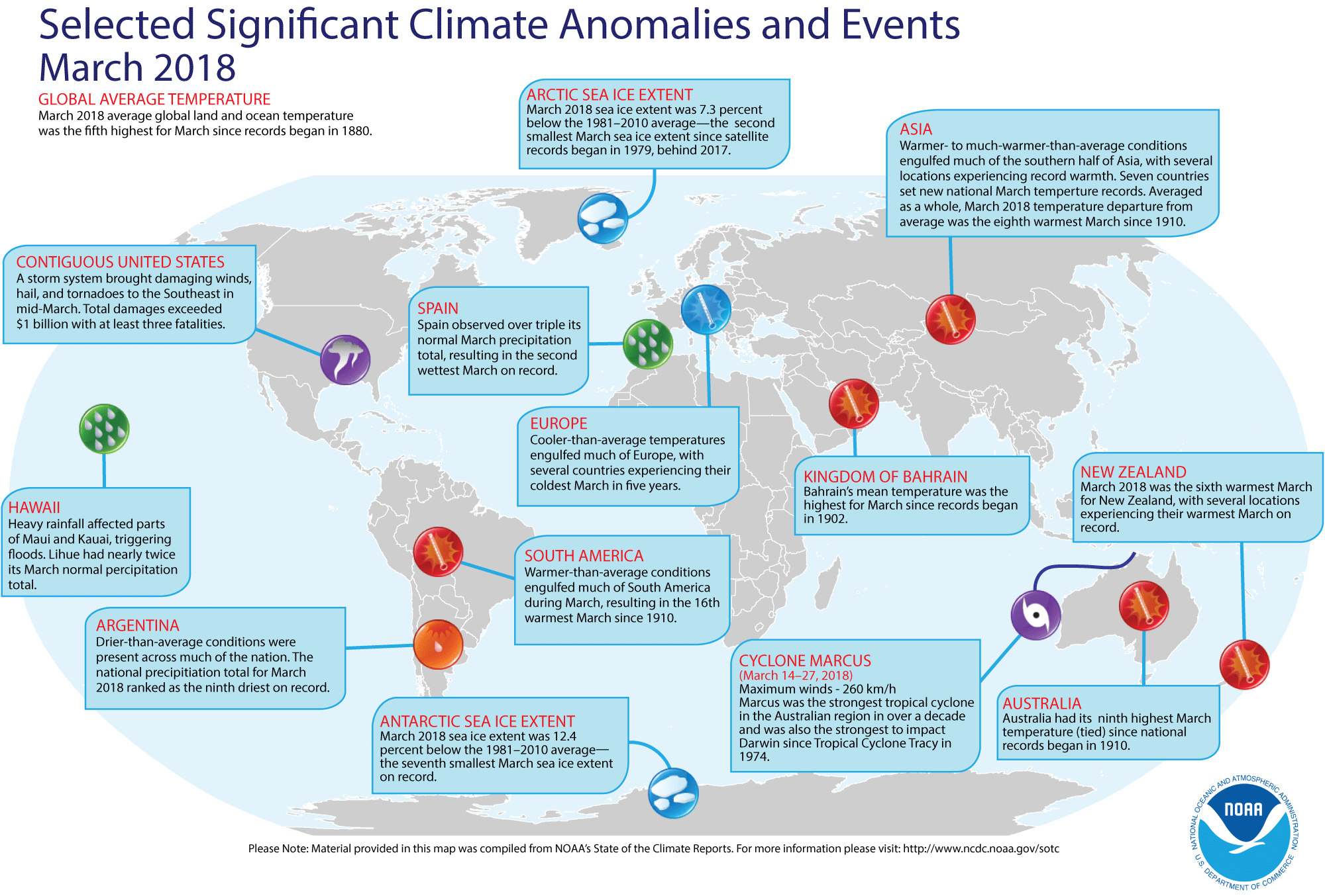
- Review of global weather and climate for March 2018 -- Using preliminary data collected from the global network of surface weather stations, scientists at NOAA's National Centers for Environmental Information (NCEI) have determined that the combined global land and ocean surface temperature for March 2018 was the fifth highest for any March since sufficiently detailed global climate records began in 1880. This global temperature for March 2018 was 1.49 Fahrenheit degrees above the 20th century (1901-2000) average.
When considered separately, the average land temperature for March 2018 was the seventh highest land temperature for any March in the 139-year period of record. Last month's average temperature over the oceans was the fifth highest for any March. Interestingly, the March 2018 monthly global combined sea-land temperature departure from the 20th century average represents the smallest March temperature departure from average since 2014.
The researchers at the National Snow and Ice Data Center noted the areal extent of the Arctic sea ice for March 2018 was the second smallest since satellite surveillance began in 1979. In addition, the extent of the Antarctic sea ice was the seventh smallest in the 39-season record. According to data from the Rutgers Global Snow Lab, the Northern Hemisphere snow cover extent for March was the 13th largest in the 52-year period of record of satellite observations. [NOAA/NCEI State of the Climate] A global map of Selected Significant Climate Anomalies and Events for March 2018 is available from NCEI.
A summary article describing the global climate for March and the year to date is available. [NOAA News]
- The 2017 hurricane season reviewed -- The
2017 hurricane season in the North Atlantic along with the eastern and central North Pacific is
reviewed and compared to the more than 150 years of record keeping in
the North Atlantic and the 40 years in the eastern North Pacific. [AMS
DataStreme Atmosphere]
CURRENT CLIMATE
MONITORING
- Latest snow of season histories are available for several thousand U.S. weather stations -- With many areas of the nation experiencing late-season snow during the first three weeks of April, interest has raised in finding the latest date of the last measurable snow of the season at a close weather station. (Measurable snow is defined as a snowfall accumulation of 0.1 inches or greater.) NOAA's National Centers for Environmental Information has assembled an interactive map that allows the user to obtain the dates of the last measurable snowfall for several thousand weather stations across the contiguous United States in the Global Historical Climatology Network that have at least 20 years of record. Clicking on a station location will provide not only the date of the latest observed snowfall at that location, but the amount of this last snow and the first year of observation for that station. [NOAA Climate.gov News] (For completeness, a corresponding interactive map has been produced last autumn from the Global Historical Climatology Network that provides the date of occurrence of the first measurable snow of the snow season.)
- New instrumentation being developed to increase views of ocean-atmosphere interactions -- Scientists at NASA's Jet Propulsion Laboratory have been developing a new Earth science radar instrument called DopplerScatt, a spinning radar unit that "pings" the ocean's surface, allowing it to take measurements from multiple directions at once. Flying onboard an aircraft, DopplerScatt will provide a new capability to measure both winds and currents simultaneously. [NASA Armstrong Flight Research Center Feature]
CLIMATE FORCING
- Greenhouse gas research campaign resumes across eastern U.S. -- Atmospheric Carbon and Transport-America (ACT-America), a five-year NASA airborne campaign designed to study the transport and fluxes of atmospheric carbon dioxide and methane, has begun its fourth campaign earlier this month. This year's six-week campaign commenced during the second week of April as flights were conducted from Shreveport, LA. During this week, the mission's base of operations has transferred to Lincoln, NE, where it will continue through the first week of May, when it will then return to the Langley Research Center in Virginia. The intent of ACT-America has been to investigate relationships between atmospheric carbon dioxide and methane concentrations and weather systems in the eastern half of the U.S. More accurate and precise estimates of the sources and sinks of these gases are needed for climate management and for prediction of future climate. [NASA Langley Research Center Feature]
CLIMATE
FORECASTS
- New Seasonal Climate Outlooks released -- During the last week, forecasters at NOAA's Climate Prediction Center (CPC) released their Three-Month (Seasonal) Climate Outlooks for the three-months running from May through July 2018, which contains the last month of meteorological spring and the first two months of two months of meteorological summer. Specific details of their outlooks include:
- Temperature and precipitation outlooks -- According to their temperature outlook, approximately 80 percent of the 48 contiguous United States should experience a high chance of above average temperatures for these three upcoming months, with the greatest probability of such an occurrence being found across sections of the Southwest (Arizona and New Mexico) and in New England and adjacent section of New York State. Only sections of the northern Rockies, the northern Plains and the Upper Midwest were expected to have nearly equal chances of warmer or cooler than normal conditions.
Their precipitation outlook calls for better than even chances of dry conditions for May through July 2018 across the northwestern quadrant of the "Lower 48", with the highest probability of dry conditions centered upon Oregon and adjacent sections of neighboring states. Conversely, the northeastern quadrant of the nation was expected to have a better than even chance of having above median precipitation. These regions that could have above average precipitation stretched from the western Great Lakes eastward to Maine and southward to North Carolina. The rest of the contiguous United States should have equal chances of below and above median precipitation for late spring and early summer. [NOAA Climate Prediction Center] Outlooks for May are also available. A summary of the prognostic discussion of the outlook for non-technical users is available from CPC. These forecasts were based in part upon the anticipated transition from a weak La Niña to ENSO-neutral conditions during late meteorological spring (May) and into early summer 2018 in the Northern Hemisphere.
- Seasonal Drought Outlook released -- The forecasters at CPC also released their US Seasonal Drought Outlook that would run from mid-April through July 2018 in which drought conditions were expected to persist across the West, primarily in the 4 Corners (Arizona, Colorado, New Mexico and Utah) and southern California, where moderate to exceptional drought conditions were currently occurring. Drought was expected to continue also across the southern Texas, the lower Missouri Valley and in Oregon, where some expansion of the drought area was anticipated. The Dakotas along with region across the Southern Rockies and the adjacent Plains currently under moderate to exceptional drought should also expected to see continued drought conditions into midsummer. Improvement in drought conditions was expected across the scattered areas Southeast. Some of these areas could be removed from drought consideration. Note: a Seasonal Drought Outlook Discussion is included describing the forecasters' confidence.
CLIMATE
AND THE BIOSPHERE
- Corals on Australia's Great Barrier Reef could survive global warming for another century -- Researchers from the University of Texas at Austin, Australia's University of Melbourne and the Australian Institute of Marine Science claim that corals in Australia's Great Barrier Reef have sufficient genetic variation to adapt to and survive rising ocean temperatures for at least another century, or more than 50 years longer than previous estimates have suggested. [University of Texas at Austin News]
- Large quantities of carbon are being absorbed along North American East Coast -- A team of scientists from seven research institutions across the nation recently reported on their research involving the construction of a carbon budget of the tidal wetlands, estuaries, and shelf waters of eastern North America using historical data and a variety of models. The researchers claim that coastal waters play an important role in the carbon cycle by absorbing approximately 20 percent of the carbon into wetland soils or nearshore sediments, while transferring the other 80 percent to the open ocean. [Lamont-Doherty Earth Observatory News]
- Grassland plants react unexpectedly to increased carbon dioxide levels -- Researchers at the University of Minnesota-Twin Cities and colleagues from the University of Wisconsin-Eau Claire and Australia's Western Sydney University recently reported on their twenty-year study involving exposing two different types of grasses to different levels of carbon dioxide (CO2). Warm-season C4 grasses and cool-season C3 grasses were used in the study, and the CO2 levels were increased from the current atmospheric levels to levels anticipated by the end of this century. For the first 12 years, researchers found what they expected regarding how different types of grasses reacted to CO2 changes, notably C3 grasses would grow more under elevated CO2, while C4 grasses would not be affected by higher CO2 levels. However, they found an unanticipated turn during the study's last eight years, where the C4 plant species grew more in an elevated CO2 environment than C3 plants. [University of Minnesota-Twin Cities News]
CLIMATE AND
SOCIETY
- National wind turbine database and associated map viewer are released to the public -- During the last week, the U.S. Geological Survey (USGS) and the U.S. Department of Energy (DOE) announced the release of the United States Wind Turbine Database (USWTDB) and the USWTDB Viewer designed to access this new public dataset on maps showing location of existing wind turbines. The USWTDB, which was developed in partnership with DOE's Lawrence Berkeley National Laboratory and the American Wind Energy Association, is a comprehensive dataset of U.S. wind turbine locations and characteristics that can be easily accessed online using the accompanying viewer. [USGS News]
- Improved weather and climate services could boost food security -- The World Meteorological Organization's (WMO) Commission for Agricultural Meteorology met last week for its quadrennial session in Incheon, Republic of Korea. The focus of the session was on improved weather and climate services for farmers and the agricultural sector in order to boost food security and sustainable development. Discussion was made on how to balance the need to provide food for a growing global population with minimizing the impact of climate change on agriculture and reducing greenhouse emissions from agriculture. [World Meteorological Organization News]
- Earthweek -- Diary of the Planet [earthweek.com]
Concept of the Week: Climate Sensitivity
Climate sensitivity is a relatively new and powerful concept
in climate science. It is a measure of how responsive the temperature
of Earth's climate system is to a change in radiative forcing due to
increases in atmospheric carbon dioxide, an important greenhouse gas,
combined with the contributions of feedbacks within the system.
Specifically, the term is defined as how much the global mean surface
temperature will increase if there is a doubling of atmospheric
greenhouse gases (in terms of equivalent CO2),
once the planet has had a chance to settle into a new equilibrium after
the increase occurs. In other words, it's an assessment of how Earth's
climate will respond to that doubling.
According to NASA climate scientist James Hansen, the concept
of climate sensitivity has its origins in a request made by President
Jimmy Carter in 1979 for the National Academy of Sciences (NAS) to
report on the potential impact on climate of the increasing atmospheric
concentration of carbon dioxide. Jule G. Charney (1917-1981) of the
Massachusetts Institute of Technology (MIT) led the Academy
investigation team. He designed a now classic experiment where computer
models of Earth's climate system had the atmospheric concentration of CO2 doubled while all other variables (except temperature) were held
constant.
The addition of CO2 makes the
atmosphere more opaque for outgoing infrared radiation (heat), warming
the lower atmosphere and cooling the upper atmosphere. Applying basic
radiation laws, Charney found that doubling the atmospheric CO2 concentration would reduce the net radiative flux (from Earth to space)
at the tropopause by a global average of about 4 watts per square meter
(W/m2). How much warmer would Earth's surface
become as a consequence of this enhanced greenhouse effect? According
to the Stefan-Boltzmann law, the radiation emitted by an object is
directly proportional to the fourth power of the object's absolute
temperature. To reestablish radiative equilibrium following a doubling
of atmospheric CO2, Earth must radiate to space
an additional 4 W/m2, brought about by a global
warming of 1.2 Celsius degrees (or 0.3 Celsius degrees per W/m2).
Charney's initial experiment accounted for the effect of a
forcing agent (i.e., atmospheric CO2) on global
climate but not the influence of feedbacks. As noted in the Concept
of the Week for Week 2, forcing agents and mechanisms drive
climate change, while feedbacks determine the magnitude of climate
change. Hence, Charney's "no-feedback" experiment significantly
underestimates the amount of global warming likely to accompany a
doubling of atmospheric CO2. With inclusion of
feedbacks, the 1979 Academy study indicated that global warming could
range from 2 to 3.5 Celsius degrees. The most recent IPCC report (AR4)
estimates the magnitude of warming with feedbacks incorporated as 3
Celsius degrees with a range of uncertainty of 2 to 4.5 Celsius
degrees. This greater sensitivity depends primarily on all the
different feedbacks, both positive and negative, that either amplify or
diminish the greenhouse effect. The three primary feedbacks involve
clouds, sea ice, and water vapor.
In summary, climate sensitivity is usually
expressed in terms of the equilibrium change in global mean annual
surface temperature caused by an increment in downward infrared
radiative flux that would result from sustained doubling of atmospheric
CO2 concentration compared to its pre-industrial
level (taken to be 280 ppmv).
Historical Events:
- 23 April 1910...The temperature at the Civic Center in Los
Angeles, CA hit 100 degrees to establish an April record for the city.
(The Weather Channel)
- 23 April 1989...Salina, KS was the hot spot in the nation
with a high of 105 degrees. The high of 105 degrees established an
April record for the state of Kansas. A total of eighteen cities in the
central U.S. reported record high temperatures for the date. (The
National Weather Summary) (Storm Data) (The Weather Channel)
- 23 April 1996...One inch of snow on this day at Cleveland,
OH brought its seasonal snowfall to 101.1 inches -- the city snowiest
winter ever. The old record was 100.5 inches set in 1981-82.
(Intellicast)
- 24 April 2003...The temperature at Juneau, AK soared to a
maximum of 70 degrees, the earliest occurrence of a 70-degree reading
for the period of record in Alaska's capital city. (The Weather Doctor)
- 25 April 1875...New York City received three inches of
snow, the latest measurable snow of record for that location. (David
Ludlum)
- 25 April 1898...The temperature at Volcano Springs, CA hit
118 degrees to establish an U.S. record for the month of April. (The
Weather Channel)
- 26 April 1991...200,000 people were killed as a cyclone caused tremendous flooding which devastated the Bay of Bengal region of Bangladesh and India. (National Weather Service files)
- 27 April 1915...The temperature at Washington, DC hit 92
degrees, the highest ever in April. New York City hit 92 degrees as
well. (Intellicast)
- 27 April 1931...The temperature at Pahala, located on the
main island of Hawaii, soared to 100 degrees to establish a state high
temperature record. (The Weather Channel)
- 27 April 1960...The highest temperature ever recorded in
Thailand reached 112 degrees at Uttaradit, Thailand. (The Weather
Doctor)
- 27 April 1988...Mount Washington, NH reported seven ft of
snow in ten days, pushing their snowfall total for the month to 89.9
in., surpassing the previous record of 89.3 in. set in 1975. Records
have been kept at the Observatory on the summit since December 1932.
(The National Weather Summary) (Intellicast)
- 27 April 2003...The largest hail storm ever recorded at Key
West, FL was reported between 4:10 and 4:20 PM, hailstones ranging in
size from one-half inch up to one and three-quarter inches fell. It is
the eleventh recorded hail event (since 1871) at Key West. (The Weather
Doctor)
- 28 April 1973...The all-time record crest of the
Mississippi River at St. Louis, MO was recorded at 43.3 ft, exceeding
the former 1884 mark by 1.9 ft. (Intellicast) This record has since
been exceeded by a record flood level of 49.6 feet on 1 August 1993.
(National Weather Service)
- 29 April 1910...The temperature at Kansas City, MO soared
to 95 degrees to establish a record for the month of April. Four days
earlier the afternoon high in Kansas City was 44 degrees, following a
record cold morning low of 34 degrees. (The Weather Channel) (The
Kansas City Weather Almanac)
North America's deadliest rockslide was caused by snowmelt followed by
temperatures near zero degrees Fahrenheit that caused water in the rock
joints under Turtle Mountain in the Canadian Rockies to freeze and
expand. Ninety million tons of limestone fell some 3000 ft onto Frank,
AB. As many as 70 people died as the result of the rockslide. (Accord's
Weather Guide Calendar)
- 29 April 1912...The highest temperature ever recorded in
Oceania was 108 degrees that occurred on this date at Tuguegarao,
Philippines. (The Weather Doctor)
- 29 April 1973...The Mississippi River reached a crest of
43.4 ft at St. Louis, MO, breaking the previous record of 42 ft
established in 1785. (David Ludlum)
Return to ECS RealTime Climate Portal
Prepared by Edward J. Hopkins, Ph.D., email hopkins@aos.wisc.edu
© Copyright, 2018, The American Meteorological Society.