WEEKLY CLIMATE NEWS
26-30 March 2018
ITEMS
OF INTEREST
- Sun sets for six months at the South Pole Station -- The occurrence of the vernal equinox last Tuesday marks the time of year when the Sun is about to set below the local horizon at the South Pole for the next six months. A photograph was made last Tuesday of the setting Sun at NOAA's South Pole Atmospheric Baseline Observatory at the U.S. Amundsen-Scott South Pole Station. Flags from the nations participating in Antarctic research surround the ceremonial South Pole marker. [NOAA Stories]
- Phenological events of note -- While astronomical spring commenced with the occurrence of the vernal equinox on Tuesday morning (20 March 2018), several reoccurring phenological events also are used to note the onset of spring. These include:
-
Buzzards return to Hinckley -- According to legend, buzzards return to Hinckley, OH on the 15th of March of every year for nearly 200 years. Apparently, some of the buzzards (turkey vultures) returned that morning as northern Ohio experienced "a perfect day for buzzard spotting." [cleveland.com] However, the traditional observance was on Sunday (19 March 2018) with the 61th Annual Buzzard Sunday in Hinckley, celebrated on the first Sunday after 15 March.[Ohio Traveler.com]
- Swallows return to Capistrano -- Legend indicates that swallows return to the Mission at San Juan Capistrano in southern California every St. Joseph's Day (19 March). The return of the swallows appears to be sporadic, with some reports of sightings near the Mission. Increased urbanization around the Mission appears to keep the swallows away. [LA Times] However, the 60th annual Swallows Day
Parade was held on Saturday 24 March 2018.
- Update on the Cherry Blossoms in Washington, DC -- Recent cold weather along with an unusually late winter storm that brought heavy, wet snow to the Washington, DC metropolitan area late last week, has caused the National Park Service to push back its forecast of peak bloom for the cherry trees surrounding the Tidal Basin in our nation's capital by over a week, until 8-12 April. The "indicator tree" hit full bloom last Thursday (22 March), which is typically 7-10 days in advance of the rest of the Yoshino trees The National Park Service's website also has a listing of the phenological observations for past bloom dates over the past 26 years. A graph of the occurrence of the dates of peak cherry blossom occurrence in Washington, DC beginning in 1921 and running through last year is also available. The 2018 National Cherry Blossom Festival changed the date of its Opening Ceremony from Saturday, 24 March 24, to Sunday, 25 March, due to anticipated crowds that were expected in downtown DC for the "March for Our Lives." The Festival will run through Sunday, 15 April 2018.
- Can summer be far behind? -- Even though snow and wintry conditions were found across sections of the northern Plains and Midwest over this past weekend, summer does not seem far off now since the official Major League Baseball season is scheduled to start this Thursday (29 March), with all 30 teams playing. This date is the earliest Opening Day in league history. A few games will be played in open air stadiums in several cold weather cities.
- Accessing the national climatographies -- NOAA's
National Climatic Data Center (NCDC) has produced numerous
climatographies that are quantitative descriptions of climate that
include tables and charts portraying the characteristic values of
selected climatic elements at a station or over an area. Some of these
climatographies provide a variety of daily, monthly and annual normal
climate data for agricultural, transportation and other interests. This
week's Supplemental Information...In
Greater Depth provides the links to selected climatographies
from NCDC.
CURRENT
CLIMATE STATUS
- Review of global weather
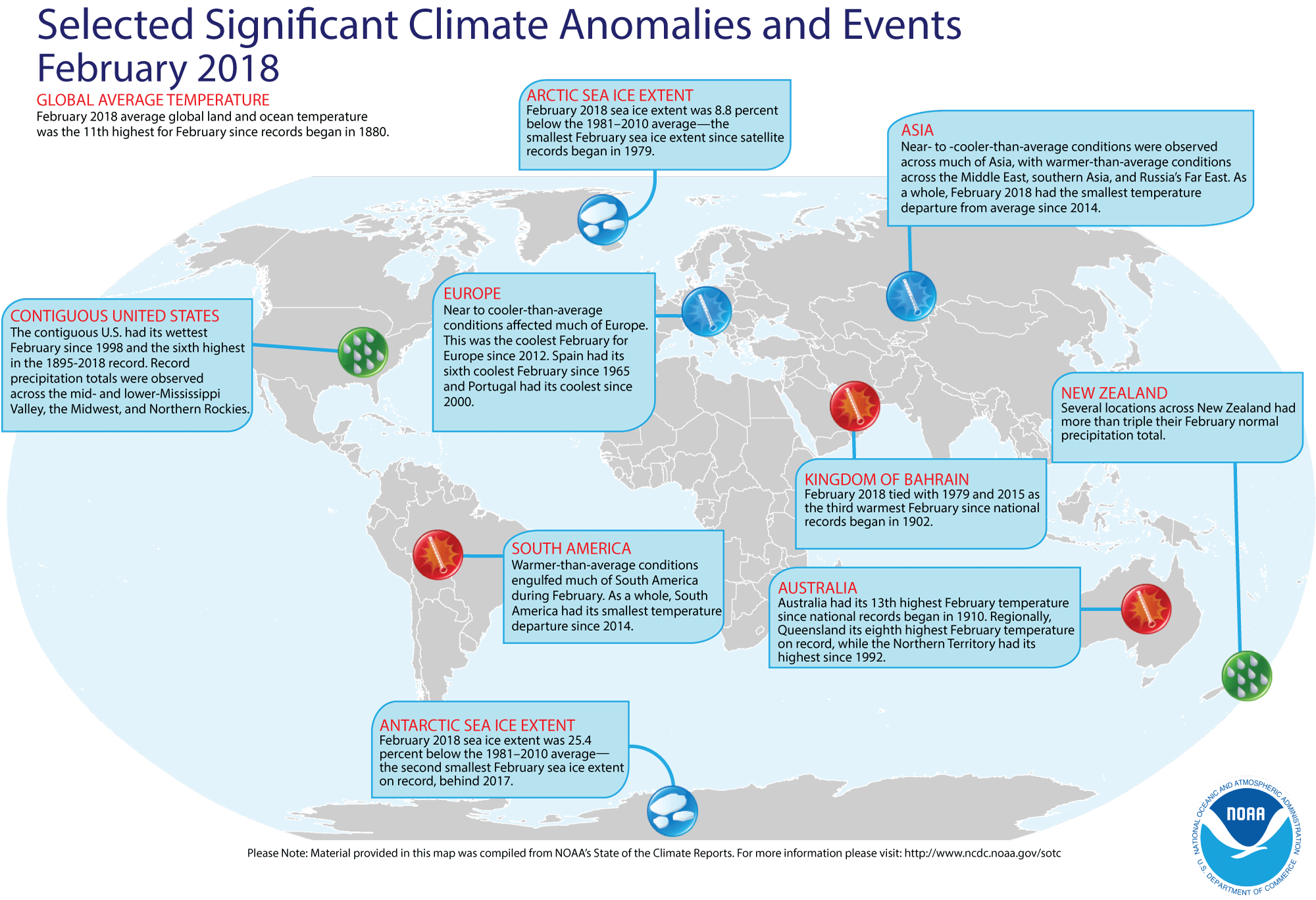
and climate for February 2018 -- Using preliminary data collected from the global network of surface weather stations, scientists at NOAA's National Centers for Environmental Information (NCEI) have determined that the combined global land and ocean surface temperature for February 2018 was 1.17 Fahrenheit degrees above the 20th century (1901-2000) average, which represents the eleventh highest global average February temperature since comprehensive global climate records began in 1880. Individually, the global ocean surface temperature for this past month was the seventh highest global ocean temperature highest in the 139-year period of record, while the average global land surface temperature for February 2018 was the fifteen highest.
Furthermore, the three-months running from December 2017 through February 2018 that constitute meteorological winter in the Northern Hemisphere (and meteorological summer in the Southern Hemisphere) had the fifth highest three-month average combined global temperature for any such interval since 1880/81. The December-February globally averaged land surface temperature was the seventh highest for December-February in the 139-year record, while the globally averaged sea surface temperature for the same three months was the sixth highest for December-February in the record.
[State of the Climate/NCEI]
NCEI also provides a map showing the Global Significant Weather and Climate Events map for February 2018.
According to the National Snow and Ice Data Center, the extent of the Arctic sea ice for this past February was the smallest monthly extent for any February in the basin since satellite surveillance began in 1979, while the extent of the sea ice surrounding Antarctica was the second smallest February sea ice on record. Furthermore, the Arctic sea ice extent appeared to have reached its annual maximum extent one week ago in mid-March, which was five days later than normal compared to the 1981-2010 median date of 12 March. [ National Snow and Ice Data Center] At the same time, the Antarctic summer minimum extent also reached a new record low. [NOAA Climate.gov News]
The extent of the Northern Hemisphere snow cover during February 2018 according to the Rutgers Global Snow Lab was the 19th largest for the 52-year period of record that started in 1967. [NOAA/NCEI Global Snow & Ice]
- A "heat wave" spreads across the Arctic basin in February -- A staff member of the National Snow and Ice Data Center posted an "Event Tracker" blog in the ClimateWatch Magazine describing the much above average temperatures that were reported during the month of February 2018 across a large area of the Arctic basin, where average monthly temperatures were as much as 25 to 35 Fahrenheit degrees above the current 30-year normals (1981-2010). Some locations in Greenland reported daily maximum temperatures at the end of February that were nearly 45 Fahrenheit degrees higher than normal. To place these temperature anomalies in perspective, the author provided a table in which a 45-Fahrenheit degree temperature increase was added to the normal high temperatures for large cities around the nation; for example, this addition would bring the normal maximum temperature at Washington, DC for the end of February to over 95 degrees Fahrenheit. [NOAA Climate.gov News]
CLIMATE
FORECASTS
- Future heat waves across Western U.S. and Great Lakes could be driven by climate change -- Researchers from NOAA's Atlantic Oceanographic Meteorological Laboratory, the University of Miami and Florida State University recently reported that their analysis of heat wave patterns across the nation indicates that a changing climate driven by the accumulation of human-caused greenhouse gases will surpass natural variability as the main cause of heat waves in the western United States by the late 2020s and by the mid-2030s in the Great Lakes region. They defined heat waves as three or more consecutive days when temperatures rose to levels among the top five hottest days of the year for a region. Climate models were run to project future heat wave patterns using a scenario of comparatively high greenhouse gas emissions. [NOAA News]
- Assessing the performance of the 2017-18 Winter Outlook -- A contractor for NOAA's Climate Program Office recently wrote a feature for the ENSO Blog in which he assesses the performance of the Climate Prediction Center's (CPC) Winter Outlook for the three winter months of December 2017 through February 2018 that was made in November 2017. Asking the question "How well did we do?" he compared the temperature and precipitation outlooks against the observed temperature and precipitation patterns across the contiguous US for these three winter months. With La Niña conditions that were expected to continue through most of the winter, the outlooks were for high probabilities of above average temperatures across the southern and eastern sections of the nation, while below average temperatures were anticipated across the Pacific Northwest and across the northern Rockies and northern Plains. He noted that large sections of the Southwest and Southeast did have above average winter temperatures as forecast, but the region of below average temperatures were found farther to the east over the northern Plains and the Upper Midwest than anticipated. The precipitation outlook, which anticipated a dry southern tier of states and above average precipitation across the northern Rockies and the Great Lakes region, did not appear to perform as well, since the more of the West and central sections of the country were drier than average. He made a quantitative verification of the outlooks using a verification metric called the Heidke Skill Score. [NOAA Climate.gov News]
CLIMATE
AND THE BIOSPHERE
- Palm trees appear to be sensitive indicators of changing climates -- A team of researchers from Columbia University's Lamont-Doherty Earth Observatory, Manitoba's Brandon University and the University of Saskatchewan recently conducted a study to investigate how plants would redistribute themselves as climate zones shift with a changing climate. One of the questions asked was how far would palm trees, the unofficial trademark of tropical landscapes, expand into northern latitudes that have long been too cold for palm trees to survive? Palms cannot propagate in freezing temperatures. The researchers analyzed a broad dataset to determine global palm tree distribution in relation to temperature and found that the absolute limit of palm distribution depends on the average temperature of a region's coldest month, which must be above 2 degrees Celsius or 36 degrees Fahrenheit. The mere presence of palms in the fossil record indicates that past temperatures remained at or above a minimum possible amount (at least 2 to 5 degrees C). Palm fossils have been identified from the Antarctic more than a 50 million years ago. The findings offer a glimpse into the possible effects of climate change; as climate zones shift northward, plant habitats might, too. [Lamont-Doherty Earth Observatory News]
PALEOCLIMATE
RECONSTRUCTION
- Rise in oxygen in ancient atmosphere revealed by two-billion-year old rocks -- An international team of researchers found evidence of a profound upswing in free oxygen in the Earth's atmosphere occurred approximately 2.3 billion years ago, at a time known as the Great Oxidation Event. This evidence was found in crystalized salt rocks extracted from a 1.2-mile-deep hole in the region of Karelia in northwest Russia. These salt crystals were left behind when ancient seawater evaporated, which provide unprecedented clues to the chemical composition of the oceans and atmosphere on Earth more than 2 billion years ago. [Princeton University News]
CLIMATE
AND HUMAN HEALTH
- Weather can trigger headaches -- In a survey conducted by the National Headache Foundation, three out of four respondents who had frequent headaches reported weather or barometric pressure changes associated with changes in elevation as triggers. In addition to weather and altitude changes, bright or flickering lights, strong odors, cigarette smoke, and loud music were frequently cited as triggers. [MedicineNet.com]
CLIMATE
AND SOCIETY
- Weather and climate data bolster nation's transportation sector -- A report was recently released evaluating the value of weather and climate data archived by NOAA's National Centers for Environmental Information (NCEI) to the nation's logistics and transportation sector that represents a $1.48 trillion segment of the U.S. economy and includes express carriers and long-haul businesses (such as the U.S. freight rail network). These weather and climate data from across the United States and globe are archived and made available to users by NCEI. [NOAA NCEI News]
- Sharp aridity gradient lies along the 100th West meridian -- A team of researchers from Columbia University have been investigating the presence of sharp gradients in population density along the 100th West meridian of longitude in North America and along an east-west line along Africa's Sahel. These gradients appear to be associated with gradients in the aridity index, a measure of the degree of dryness of the region's climate, often determined by its potential evapotranspiration that indicate the possibility of a deficit of available water. The existence of a aridity gradient traversing the American Great Plains along the 100th meridian has been well known for at least 150 years, as it marks the boundary between the humid area to the east where farming is practiced without irrigation and the arid region to the west where dry-land farming and ranching take place. The researchers claim that this boundary is gradually migrating eastward and is now more closely aligned with the 98th meridian of longitude due to a changing climate. [Earth Magazine]
- National coastal vulnerability is addressed -- A NOAA technical report entitled "Patterns and projections of high tide flooding along the U.S. coastline using a common impact threshold" was recently released that intends to provide an objective and nationally consistent set of impact thresholds for minor/moderate/major coastal flooding. The report was made by sea level experts from NOAA's Center for Operational Oceanographic Products and Services, who looked at existing flood thresholds established by the National Weather Service. They found patterns in the thresholds based upon tide range, which permitted them to apply that pattern nationwide and find a statistical and consistent way to measure and monitor minor high tide flooding, as well as moderate and major flooding in locations where no threshold exists. [NOAA National Ocean Service News]
- Earthweek -- Diary of the Planet [earthweek.com]
Concept of the Week: Feedback in Earth's
Climate System
In Earth's climate system, feedback consists of a
process where a change in one variable interacts with other variables
of the system to alter that original variable. If the change reinforces
the original quantity, it is known as a positive feedback.
If the change suppresses the original quantity, it is a negative
feedback. Feedbacks in Earth's climate system are
significant--thought to be responsible for more than half the global
warming expected from human activities.
Consider examples of positive and negative feedback. A warming
trend in climate is likely to accelerate the rate of melting of snow
and ice, producing more bare ground that absorbs more solar radiation,
further raising the air temperature. A cooling trend prolongs snow and
ice cover in spring and summer so that less solar radiation is
absorbed, more reflected to space, bringing about additional cooling.
In both cases, feedback is positive because the initial change in
temperature is amplified.
Consider an example of negative feedback. While feedbacks
among temperature, cloud cover, and radiation are not well understood
and depend upon circumstances (e.g., type and height of clouds), they
could be either positive or negative. It is thought that a warming
trend in climate should increase the rate of evaporation of water from
Earth's surface and thereby increase low cloud cover. A thicker and
more extensive low-cloud cover reflects more solar radiation to space
thereby inhibiting a further rise in surface temperature. Hence, this
negative feedback would dampen the initial temperature change.
Understanding feedback in the climate system is essential for
modeling and predicting climate change. If some agent or mechanism
alters the climate, then feedback may either amplify (positive
feedback) or dampen (negative feedback)
the change in climate. As demonstrated later in this course, many
agents and mechanisms can bring about climate change (e.g., variations
in solar energy output, regular fluctuations in Earth-Sun geometry).
While these climate forcing agents and mechanisms drive climatic
change, processes within the planetary climate system involving
feedbacks significantly impact the magnitude of climate change.
Overall, which type of feedback prevails in Earth's climate
system, positive or negative? A system in which positive feedback
prevails is unstable. For Earth, this would move the climate regime
toward an extreme characterized by excessive cold that would encase the
planet in snow and ice ("snowball" or "ice ball" Earth) or toward the
other extreme resulting in much higher temperatures--the product of a
runaway greenhouse effect. Although Earth's climate has varied
considerably over the billions of years that constitute geologic time,
it appears likely that Earth's climate system has been nearly stable
with negative feedbacks generally compensating for positive feedbacks.
Historical Events:
- 26 March 1913...The Ohio River Basin flood reached a peak.
Ten-inch rains over a wide area of the Ohio River Basin inundated
cities in Ohio, drowning 467 persons, and causing 147 million dollars
damage. The Miami River at Dayton reached a level eight feet higher
than ever before. The flood, caused by warm weather and heavy rains,
was the second mostly deadly of record for the nation. (David Ludlum)
- 26 March 1930...A two-day snowfall of 19.2 inches at
Chicago, IL was the greatest modern snowfall on the record books at
Chicago. (Intellicast)
- 26 March 1954...The temperature at Allakaket, AK plunged to
69 degrees below zero, setting a record for the lowest temperature ever
for March. (The Weather Channel)
- 26-28 March 2004...The first ever confirmed hurricane in the
South Atlantic Ocean, named Catarina, struck the coast of the Brazilian
states of Santa Catarina and Rio Grande do Sul with heavy rains and
winds, before dissipating over land late on the 28th. (The Weather
Doctor)
- 27 March 1931...A blizzard that struck western Kansas and
adjoining states was called the "worst since January 1888". The low
temperature of 3 degrees below zero, which was reached during the
blizzard, stands as the lowest temperature recorded so late in the
season. (Intellicast)
- 27-28 March 1964...The most powerful earthquake in US
history, the Good Friday Earthquake, rocked south central Alaska,
killing 125 people and causing $311 million in property damage,
especially to the city of Anchorage. The earthquake in Prince William
Sound, which had a magnitude of 9.2 on the Richter scale, caused some
landmasses to be thrust upward locally as much as 80 feet, while
elsewhere land sank as much as 8 feet. This earthquake and submarine
landslides also created a tsunami that produced extensive coastal
damage. A landslide at Valdez Inlet in Alaska generated a tsunami that
reached a height of 220 feet in the inlet. A major surge wave that was
approximately 100 ft above low tide caused major damage to Whittier
(where 13 died) and other coastal communities in Alaska. The first wave
took more than 5 hours to reach the Hawaiian Islands where a 10-foot
wave was detected, while a wave that was 14.8 feet above high tide
level traveled along portions of the West Coast, reaching northern
California 4 hours after the earthquake. Nearly 10,000 people jammed
beaches at San Francisco to view the possible tsunami, but no
high-amplitude waves hit those beaches. Tsunami damage reached Crescent
City in northern California. Tens of thousands of aftershocks indicated
that the region of faulting extended about 600 miles. The Alaska
Tsunami Warning Center was established in the wake of this disaster,
with a mission to warn Alaskan communities of the threat from tsunamis.
(Accord's Weather Guide Calendar) (US Coast Guard
Historians Office)
- 27 March 1984...A strong storm system traversing northern
Texas pulled very hot air northeastward into southern Texas. The
temperature at Brownsville, TX soared to 106 degrees, which broke not
only the monthly record high temperature but the all-time record as
well. Cotulla, TX reached 108 degrees, equaling the March record for
the U.S. (The Weather Channel) (Intellicast)
- 27-28 March 2009...A blizzard moving across the southern
Plains was responsible for new 24-hour snowfall records for the states
of Kansas, Oklahoma and Texas. A 30.0-inch snowfall at Pratt eclipsed
the previous Kansas 24-hour record of 24 inches set at Norcator on 26
October 1996. Freedom and Woodward in Oklahoma replaced the 24.0-inch
state snowfall record at Buffalo on 21 February 1971. In Texas, 25.0
inches fell at Follett, which broke the previous 24.0-inch record at
Plainview set on 4 February 1971. (Accord Weather Guide Calendar)
- 28 March 1902...McMinnville, TN (elevation 900 feet)
received 11.00 inches of precipitation, setting a 24-hour precipitation
record for the Volunteer State. (National Climate Data Center).
- 28 March 1955...Florida's latest measurable snowfall occurred
at Marianna when one inch of snow fell. Ground is whitened further
south in Panama City. (The Weather Doctor)
- 28 March 2004...The only known South Atlantic hurricane was recorded as Tropical Cyclone Catarina's winds hit 100mph. (National Weather Service files)
- 29 March 1879...The temperature at Los Angeles, CA climbed
to 99 degrees, which was 3 degrees higher than any other March day had
ever reached in the city. (Intellicast)
- 29 March 1886...Atlanta, GA was drenched with a record 7.36
inches of rain in 24 hours. (The Weather Channel)
- 29 March 1920...Clear Spring, MD received 31 inches of snow
in 24 hours to establish a state record. (Sandra and TI Richard Sanders
- 1987)
- 29 March 1942...The "Palm Sunday snowstorm" buried
Baltimore, MD under 22 inches of snow in 24 hours. This was the
heaviest 24-hour snowfall ever for the city for the month of March as
well as the heaviest snow for so late in the season. (Intellicast)
- 29 March 1945...Providence, RI hit 90 degrees to establish
a March record for the New England area. (The Weather Channel)
- 30 March 1977...Hartford, CT hit 87 degrees to establish a
record for the month of March. (The Weather Channel)
- 31 March 1890...Saint Louis, MO received 20.4 inches of
snow in 24 hours, which was the worst snowstorm of record for St.
Louis. (David Ludlum)
- 31 March 1942...Puu Kukui at Maui, Hawaii recorded 107 inches of rain during the month to set the U.S. record for rainfall in one month. The same place also holds the annual rainfall record for the United States with 578 inches in 1950. (National Weather Service files)
- 31 March 1954...The temperature at Rio Grande City, TX hit
108 degrees, which for thirty years was the U.S. record high for the
month of March. (The Weather Channel)
- 31 March 1992...Seattle, WA closed out its first snowless
winter ever (November through March). Las Vegas, NV recorded 4.80
inches of rain during the past month, which set 2 records -- the
wettest March ever (old record 1.83 inches set in 1973) and the wettest
month ever (old record 3.39 inches in September 1939). The normal
yearly rainfall for the city is only 4.19 inches! (Intellicast)
Return to RealTime Climate Portal
Prepared by Edward J. Hopkins, Ph.D., email hopkins@meteor.wisc.edu
© Copyright, 2018, The American Meteorological Society.