WEEKLY CLIMATE NEWS
26 February-2 March 2018
ITEMS
OF INTEREST
- A change in meteorological seasons -- Wednesday, 28 February 2018, marks the end of meteorological winter in the
Northern Hemisphere, which by convention, is the three-month interval of December, January and February. The following day (1 March 2018)
represents the beginning of boreal meteorological spring, the three-month interval of March, April and May. At the same time, summer in the
Southern Hemisphere ends and autumn begins.
- Leap years and calendars -- This year (2018) is considered a "normal" year with 365 days. Two years ago, 2016 was a leap year with 366 days, with one additional day inserted at the end of February. Since the Earth completes one orbit around the Sun in 365.2422 days, calendars based upon integer days must be adjusted every few years so that recognizable events, such as the occurrence of the vernal equinox, do not progress through the year. In the first century BC the Julian calendar was developed by Julius Caesar who decreed a calendrical reform with a 365-day year that involved the inclusion of
an extra day to the end of February (the last month of the old Roman year). However, over several centuries, the timing of the vernal equinox (and the Christian celebration of Easter) crept earlier by roughly 10 days. To correct this inconsistency, an additional reform was instituted by Pope Gregory
XIII in 1572 that included the requirement that only those centurial years divisible evenly by 400 would be leap years, while the other
centurial years (e.g., 1800 and 1900) would not.
The National Centers for Environmental Information (formerly National Climatic Data Center) recommends that the climate normals
for 28 February be used also for 29 February in a leap year.
- High-quality maps of March temperature and precipitation normals across US available -- The PRISM Climate Group at Oregon State University's website has prepared high-resolution maps depicting the normal maximum, minimum and precipitation totals for March and other months across the 48 coterminous United States for the current 1981-2010 climate normals interval. These maps, with a 800-meter resolution, were produced using the PRISM (Parameter-elevation Regressions on Independent Slopes Model) climate mapping system.
- March weather calendar for a city near you -- The Midwestern Regional Climate Center maintains an interactive website that permits the public to produce a ready to print weather calendar for any given month of the year, such as March, at any of approximately 270 weather stations around the nation. (These stations are NOAA's ThreadEx stations.) The entries for each day of the month includes: Normal maximum temperature, normal minimum temperature, normal daily heating and cooling degree days, normal daily precipitation, record maximum temperature, record minimum temperature, and record daily precipitation; the current normals for 1981-2010.
- Start of Alaska's "Last Great Race" is scheduled for next weekend -- The 2018 Iditarod Trail Sled Dog Race will begin on the morning (Alaska time) of Saturday, 3 March 2018, with a ceremonial start from downtown Anchorage. A restart will be on Sunday morning when the 67 dog teams head out along the trail from Willow Lake in Willow, a community approximately 75 miles north of Anchorage. The final destination is at Nome, approximately 1000 miles distant. A northern route (through Cripple, Ruby and Galena) will be taken as this year is an even-numbered year. Last year, the ceremonial start was from Fairbanks because of poor conditions in critical trail areas in the Alaska Range. A website is maintained for teachers and students interested in following the progress of the Iditarod and a 5th-grade teacher from Virginia, who is the "2018 Iditarod Teacher on the Trail™." The race should be completed in 10 to 17 days.
Current weather conditions and weather forecasts for this year's checkpoint stations are available.
- Monitoring the drought -- Read this
week's Supplemental Information...In
Greater Depth for information concerning assessing current
drought conditions across the nation.
- Drought conditions have worsened across Southwest and southern Plains -- A meteorologist with the NOAA Climate Prediction Center has written a feature for the ClimateWatch Magazine along with animations that describes the expansion of drought conditions across a large section of the 48 contiguous United States during the last six months. The Southwest and the southern Plains have borne the brunt of the deepening drought. [NOAA Climate.gov News]
CURRENT
CLIMATE STATUS
- Monitoring Great Lakes ice cover from space -- False-color images of the North American Great Lakes were made from data acquired in mid-February by the MODIS sensor on NASA's Aqua satellite. These images showed that 57.9 percent of the surfaces of all Great Lakes were covered at that time, with the relatively shallow Lake Erie having the most ice cover with 93.3 percent. The cold air that has spread across eastern North America this winter has been responsible for the largest expanse of ice across the Great Lakes in three winters. [NASA Earth Observatory]
- Satellite reveals a snow drought across the Rockies -- Comparisons of maps of fractional snow cover generated from data obtained by the MODIS sensor on NASA's Terra satellite during the last week of January 2018 and in late January 2016 show this year's relatively meager snowpack in the southern Rockies, extending from southern Wyoming across Colorado, Utah and New Mexico. However, above average snowpack was found across Montana and northern Wyoming. [NASA Earth Observatory]
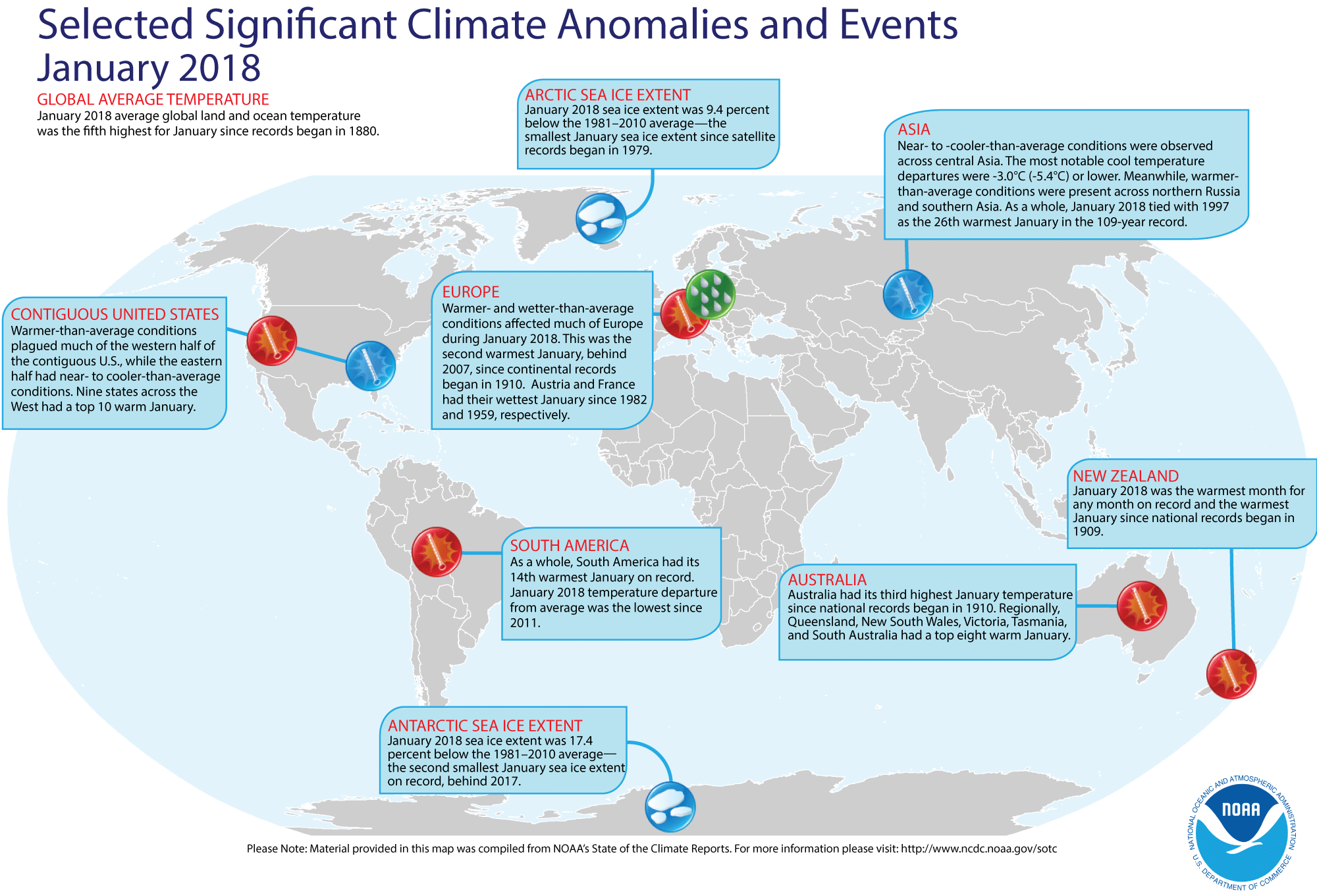
- Review of global weather
and climate for January 2018 -- Using preliminary data collected from the global network of surface weather stations, scientists at NOAA's National Centers for Environmental Information have determined that the combined global land and ocean surface temperature for January 2018 was 1.28 Fahrenheit degrees (or 0.71 Celsius degrees) above the 20th-century (1901-2000) average, which makes last month the fifth highest global temperature for any January since global climate records began in 1880. When considering land and ocean separately, the January 2018 ocean surface temperature tied January 1998 for the fifth highest in the 139-year record, while the global land surface temperature for January 2018 was eighth highest. [NOAA/NCEI State of the Climate] According to the National Snow and Ice Data Center, the
extent of Arctic sea ice was the smallest monthly extent for any January since satellite surveillance began in 1979. Antarctic sea ice extent in January was the second smallest on record in the Southern Hemisphere, following the record smallest in January 2017.
The extent of the Northern Hemisphere snow cover during January 2018 was the twenty-sixth smallest (or twenty-seventh largest) for the period of record that started in 1967. [NOAA/NCEI Global Snow & Ice]
NCEI also provides a map showing the Global Significant Weather and Climate Events map for January 2018.
CURRENT CLIMATE MONITORING
- NOAA's largest research ship to deploy instruments that collect ocean data for weather and climate prediction -- Two weeks ago the NOAA Ship Ronald H. Brown from its homeport of Charleston, SC on a round-the-world trip designed to improve the collection of ocean data that influence weather and climate prediction not only for the United States, but also the globe. The ship will first investigate ocean currents in the North Atlantic that influence global climate and then it will replace four instrumented observing moorings in the Prediction and Research Moored Array in the Atlantic (PIRATA). These PIRATA moorings are part of a larger tropical observing system of buoys that provides ocean and atmospheric data that helps the international scientific community predict droughts, floods, hurricanes and other weather affecting millions of people in the Americas and Africa. Rounding the Cape of Good Hope, the Ron Brown will conduct two major research campaigns to advance ocean observing, with the second campaign designed to launch three new moorings in the Arabian Sea as part of the Research Moored Array for African-Asian-Australian Monsoon Analysis and Prediction (RAMA). This moored array is designed to understand the role of the Indian Ocean in driving monsoons. [NOAA Office of Oceanic & Atmospheric Research News]
- New version of "Sea Ice Concentration Climate Data Record" is available -- NOAA's National Centers for Environmental Information recently made a new version of the "Sea Ice Concentration Climate Data Record" from its Climate Data Record (CDR) program. The Sea Ice Concentration CDR provides consistent daily and monthly time series of sea ice concentrations for both the north and south polar regions, with some other variables dating back to October 1978. The new version of the record provides users with the most current preliminary sea ice data in near-real time. [NOAA NCEI News]
CLIMATE
FORECASTS
- Potential exists to predict atmospheric river activity up to five weeks in advance -- A team of atmospheric scientists at Colorado State University have developed a model that centers on the relationship between the Madden-Julian Oscillation (MJO) and the Quasi-Biennial Oscillation (QBO) to predict the behavior of atmospheric rivers several weeks in advance. The MJO is a recurring tropical rainfall pattern in the troposphere, while the QBO is an alternating pattern of winds high up in the stratosphere. The atmospheric rivers are long plumes of humid air along with clouds and precipitation that can stream thousands of miles across the Pacific Ocean from the tropics and provide water to the West Coast of North America. The researchers had developed their model based upon analysis of 37 years of historical weather data. [NOAA Office of Oceanic & Atmospheric Research News]
- Weather predictability should remain the same despite a changing climate -- Atmospheric scientists at the University of Missouri and their Russian colleagues claim that despite changes in climate associated with increases in global temperature by mid-century created by increases in rising levels of atmospheric carbon dioxide, the weather should remain predictable. They base their conclusions on numerical simulations of the behavior of the jet stream in the Northern Hemisphere run with increased atmospheric carbon dioxide. The variability of the jet stream on the 10 to 12 day time scale, within the realm of weather predictability, remained the same with these increased carbon dioxide levels. [University of Missouri News]
CLIMATE
FORCING
- The Madden Julian Oscillation has been active this winter and has influenced weather across the nation -- A scientist with the NOAA Climate Prediction Center wrote an ENSO blog for the ClimateWatch Magazine that describes the Madden Julian Oscillation (MJO), a major player in tropical weather patterns represented by a pulse of clouds and precipitation that travels eastward along the equator, making a circuit of the globe in 30 to 60 days. She shows how the MJO during this meteorological winter (December 2017 through February 2018) was relatively active and demonstrates how the MJO has caused dramatic changes in weather patterns across the midlatitudes, especially over the United States over the last three months. [NOAA Climate.gov News]
- Violent Indonesian volcanic eruption seen by passing satellite -- A natural-color image was generated from data collected at the beginning of last week by the MODIS sensor onboard NASA's Terra satellite as it passed over Indonesia's Mount Sinabung only after this stratovolcano erupted. The image shows a cloud of volcanic ash and condensate rising up to an altitude of 5 to 7 kilometers above the volcano that is located on the island of Sumatra. A map showing concentrations of atmospheric sulfur dioxide gas in the vicinity of the volcano was produced from data collected by the Ozone Mapper Profiler Suite (OMPS) on the NOAA/NASA Suomi-NPP satellite. Instruments on NASA's CALIPSO and Aura satellites also detected sulfur dioxide gas and volcanic debris rising upward to at least 15 km. Injection of these materials into the stratosphere could result in a cooling of the Earth's climate. [NASA Earth Observatory]
- Layout of a city can influence its urban heat island effects -- Scientists from the Massachusetts Institute of Technology (MIT) and the University of California at Irvine recently reported that their research indicates the arrangement of a city's streets and buildings appears to play a crucial role in the local urban heat island effect, which causes the temperatures in cities to rise by as much as 10 Celsius degrees higher than their surroundings. The researchers found that those cities that were laid out in a grid ("crystalline" cities) had a far greater buildup of heat compared to their surroundings than did the cities that had a more chaotic or "glass-like" arrangement. Apparently, the differences in the heating effect were a result of the way buildings reradiate heat that can then be reabsorbed by other buildings that face them directly, [MIT News]
- Assessing how ocean tides affect ice loss from large polar ice sheets -- Researchers from Earth & Space Research, a non-profit research institute in Oregon, and Stanford University recently reported how ocean tides affect the motion and loss of ice from the marine edges of both the Greenland Ice Sheet and Antarctica. Tides and their actions are in turn affected by climate change, as with changes in sea level and coastlines caused by climate change, which in turn affect the magnitude and timing of tides. [EOS Earth & Space Science News]
PALEOCLIMATE
RECONSTRUCTION
- Major climate differences seen in extinct lakes across the American western desert -- A scientist from Stanford and colleagues have been studying the fossil lake shorelines and lake sediments from extinct lakes that dotted the American desert west over the past three million years. They found the lakes existed during two distinct periods with different climates. One period with lakes was approximately three million years ago during the middle of the Pliocene epoch when the climate was warm and atmospheric carbon dioxide levels were close to present day values. The other period with lakes was during the last Pleistocene ice age between 30,000 to 14,000 years ago, which had a cooler climate along with widespread continental ice sheets across North America. The researchers found that increased precipitation during the warmer middle Pliocene drove the formation of lakes, particularly in southern Nevada and southern California, outpacing higher temperatures and evaporation rates. During colder glacial periods, increased precipitation and decreased evaporation combined to form large lakes that occupied the inward draining basins in the western United States, particularly in northern Nevada and Utah. [Geo Society News]
CLIMATE AND
SOCIETY
Concept of the Week: Keeping your cool!
In order to survive, humans need to maintain a nearly constant
internal core temperature that is within several degrees of 98.6
degrees Fahrenheit. Your internal temperature depends upon an energy
balance involving the gain and loss of energy from radiation (incoming
solar versus incoming and outgoing infrared radiation), sensible heat
transfer (conduction and convection), latent heat of evaporation
(respiration and perspiration) and the body's metabolic rate. This heat
transfer depends upon the differences between skin temperature and the
ambient air temperature of the surroundings. In addition, wind and
atmospheric humidity can affect the rate of sensible and latent heat
transfer. Problems arise when either too much or too little heat flows
to or from the body, yielding hypothermia and hyperthermia (heat
stress) conditions, respectively.
When the air temperature increases, heat flow from the body is
often reduced. Heat flow can be increased to maintain stable
temperatures involuntarily by thermoregulatory processes such as
increased perspiration (sweating) and dilation of the blood vessels.
Humans can also act to prevent hyperthermia by selecting lightweight
and light-colored clothes, as well as seeking of shade and well-ventilated locations. Unfortunately, high atmospheric humidity that
often accompanies high summer temperatures also reduces body heat loss
since evaporative cooling by perspiration is suppressed. During the
summer, the National Weather Service alerts the public of potentially
dangerous combinations of high air temperature and atmospheric humidity
levels by calculating the Heat Index.
Statistics kept by the National Weather Service reveals that
heat (along with high humidity) is responsible for the greatest number
of weather-related deaths across the nation during the 10-year period
(2001-2010), with 115 fatalities occurring per year. By comparison, 116
fatalities per annum are caused by tropical cyclones (hurricanes and
tropical storms), 56 deaths per year are associated from tornadoes and
25 deaths annually caused by the cold (low temperatures). (Note: The
large number of fatalities associated with the hurricanes of 2005,
which totaled 1016 deaths in the US due primarily to Hurricane Katrina,
has inflated the annual averages associated with tropical cyclones.)
Furthermore, concern has been raised that during this century, more
frequent and more severe heat waves due to global climate change could
become more common, leading to a greater risk of hyperthermia and,
ultimately, to higher morbidity rates.
Historical Events:
- 26 February 1969...Both Portsmouth, NH and Portland, ME set
new single storm snowfall records with 33.8 inches and 26.9 inches,
respectively. (Intellicast)
- 26 February 2007...The world record was set for 72-hour rainfall: 154.70 inches at Cratere Commerson, La Reunion. (National Weather Service files)
- 27 February 1717...What was perhaps the greatest snow in
New England history commenced on this date. During a ten-day period, a
series of four snowstorms dumped three feet of snow upon Boston, and
the city was snowbound for two weeks. Up to six feet of snow was
reported farther to the north, and drifts covered many one-story homes.
The storms killed 95 percent of New England's deer population. (David Ludlum) (National Weather Service files)
- 27 February 1988...Rapid City, SD established a February
record with an afternoon high of 75 degrees. (The National Weather
Summary) (Storm Data)
- 28 February 1900...A massive storm spread record snows from
Kansas to New York State. The 18.7 inches of snow measured at Topeka,
KS in 24 hours was the city's greatest 24-hour snowfall on record.
(David Ludlum) (Intellicast)
- 28-29 February 1964...A world 12-hour rainfall record was
set at Belouve, La Reunion Island in the western Indian Ocean when
52.76 inches of rain fell. World records for 9 hours and 18.5 hours
were also set with 42.79 and 66.49 inches, respectively. (Accord's
Weather Calendar) (The Weather Doctor)
- 28 February 1972...Unseasonably mild weather prevailed
throughout the central US. Temperatures soared to 83 degrees in Kansas
City, MO, setting an all-time high record for the month of February.
(Intellicast)
- 28 February 1988...Unseasonably mild weather prevailed in
the northwestern U.S. The afternoon high of 71 degrees at Portland, OR
was a February record. (The National Weather Summary) (Storm Data)
- 29 February 1884: San Diego, California saw its wettest February in history with 9.05 inches. February 1884 is currently the third wettest month on record (wettest: 9.26 inches in 12/1921). The year of 1884 ended as the wettest in San Diego history with 25.97 inches (National Weather Service files)
- 29 February 1964...Thompson Pass, AK finished the month
with 346.1 inches of snow, a record monthly total for the state of
Alaska. (The Weather Channel)
- 1 March 1910...The deadliest avalanche of record in the
U.S. thundered down the mountains near Wellington Station, WA sweeping
three huge locomotive train engines and some passenger cars off the
tracks, over the side and into a canyon, burying them under tons of
snow. This train was snowbound on the grade leading to Stevens Pass.
The avalanche claimed the lives of more than 100 people. The station
house at Wellington was also swept away. (The Weather Channel)
- 1 March 1993...4.5 inches of snow fell at Dodge City, KS on
this date to raise its seasonal snowfall total to 58.8 inches. This set
a new all-time seasonal snowfall record for the city. The old record
was 57.5 inches set back in the winter of 1911-12. (Intellicast)
- 2 March 1927...Raleigh, NC was buried under 17.8 inches of
snow in 24 hours, a record for that location. Nashville, NC received 31
inches of snow. The average snow depth in the state of Carolina was
fourteen inches. (The Weather Channel)
- 2 March 1947...The one-day record snowfall of 16 inches of
snow buried Canada's capital city of Ottawa, Ontario. The storm left
28.7 inches of snow covering the Ottawa region. (The Weather Doctor)
- 2 March 1996...Another East Coast snowstorm deposited 4.6
inches of snow at Central Park in New York City to bring its seasonal
snowfall total to 66.3 inches, breaking the old season snowfall record
of 63.2 inches set in 1947-48. (Intellicast)
- 3 March 1896...The temperature in downtown San Francisco,
CA fell to 33 degrees, which was the lowest ever for the city in March.
(Intellicast)
- 3 March 1971...An extremely intense coastal storm blasted
the northeastern US on this day and continued into the 4th. The
barometric pressure dropped to 960 millibars (28.36 inches) at
Worcester, MA for the lowest pressure ever recorded at the location.
The same record was set at Concord, NH with a reading of 963 millibars
(28.44 inches). Wind gusts 70 to 100 mph lashed eastern New England
with major wind damage occurring. Tides ran 4 to 5 feet above normal
resulting in extensive coastal damage and beach erosion. (Intellicast)
- 3 March 1994...A major coastal storm was in progress over
the mid-Atlantic and the Northeast. The 8.7 inches of snow at
Allentown, PA raised its seasonal snowfall to 69.2 inches for its
snowiest winter ever. Boston's 8 inches pushed its seasonal snow to
89.5 inches for its snowiest winter as well. (Intellicast)
- 3 March 2003...The day's low temperature of 30 degrees
below
zero at Marquette, MI was the lowest temperature ever recorded in March
in the city. (The Weather Doctor)
- 4-5 March 1899...Tropical Cyclone Mahina ("the Bathurst Bay
Hurricane") crossed Australia's Great Barrier Reef and generated
produced the highest storm surge ever recorded: 13-14.6 m (42.6-47.8 ft) surge in
Bathurst Bay. The Australian pearling fleet was destroyed, over 100
shipwrecks reported and 307 people killed, making Mahina the largest death toll of any natural disaster in Australian history. Minimum central pressure
barometric pressure fell to an unofficial reading of estimated at 914
millibars (26.90 inches of mercury). (Accord's Weather Calendar) (The
Weather Doctor) (National Weather Service files)
- 4 March 1953...Snow was reported on the island of Oahu in
Hawaii. (The Weather Channel)
- 5 March 1960...The greatest March snowstorm of record in
eastern Massachusetts began to abate. The storm produced record 24-hour
snowfall totals of 27.2 inches at Blue Hill Observatory, 17.7 inches at
Worcester, and 16.6 inches at Boston. (The Weather Channel)
Return to RealTime Climate Portal
Prepared by Edward J. Hopkins, Ph.D., email hopkins@aos.wisc.edu
© Copyright, 2018, The American Meteorological Society.