WEEKLY OCEAN NEWS
21-25 May 2018
Items of Interest:
- National Maritime Day will be observed -- Tuesday, 22 May 2018, has been declared National
Maritime Day, a day created to recognize the maritime
industry. The holiday was created by the United States Congress on 20
May 1933. The date of 22 May was selected because on 22 May 1819, that
the American steamship Savannah set sail from
Savannah, GA on the first ever transoceanic voyage under steam power.
- North American Safe Boating Week -- The 2018 National Safe Boating Week will continue through Friday, 25 May. This week helps launch the 2018 North American Safe Boating Campaign. Check the Safe Boating Week site maintained by the Safe Boating Council. Several states, primarily in New England will be conducting their own state Safe Boating and Beach Safety Weeks. California will have Safe Boating Cold Water Awareness Week.
- Zenithal Sun -- Late this week (25-27 May) marks one of the two times during the year when the noontime sun is directly overhead to residents on Oahu (Honolulu metropolitan area). [US Naval Observatory, Data Services]
- Reviewing historical highlights of the U.S. weather observer program -- The chief of the dataset branch in the Center for Weather and Climate at NOAA's National Centers for Environmental Information (NCEI) posted a blog on the "Beyond the Data" site providing historical insight into the more than two centuries of weather data that have been collected across the United States and now archived at NCEI. He describes the entries made into a weather log book maintained by Thomas Jefferson, the third President of the U.S., in 1776. Attention was also given to the weather observers who were part of organizations that were predecessors to the current National Weather Service, including the U.S. Army's Medical Corps and Signal Service, and the U.S. Weather Bureau. The Smithsonian Instution's network of the mid-19th century is also mentioned, along with the current Cooperative Observer Program (COOP) that began in 1890. [NOAA Climate.gov News]
Ocean in the News:
- Eye on the tropics --- Several tropical cyclones were reported during the last week:
- In the western North Pacific, Tropical Cyclone 4-W, which had strengthened to a tropical storm over the previous weekend, weakened by the start of last week as it traveled toward the northwest approximately 400 miles to the southeast of Iwo To (formerly known as Iwo Jima). At that time, this system had become a tropical depression. By early Tuesday local time, remnants of this tropical cyclone finally dissipated to the northwest of Agrihan, an island in the Northern Mariana Islands. Additional information and a satellite image for Tropical Cyclone 4-W can be found on the NASA Hurricane Page.
- In the Northern Indian Ocean basin, the first tropical cyclone of the year for the Arabian Sea formed last Thursday over the waters of the Gulf of Aden approximately 260 miles to the east of Aden, Yemen. Originally called Tropical Cyclone 1A, it was later named Tropical Storm Sagar as it strengthened while moving westward. Curving toward the west-southwest. Sagar made landfall in Somalia on Saturday after traversing the Gulf of Aden between the Arabian Peninsula and the Horn of Africa. Torrential rains along with strong winds accompanied Sagar affected coastal communities in Yemen and then northern sections of Somalia and Djibouti, which resulted in flooding. One fatality was reported in Yemen. According to Al Jazerra, Sagar was a relatively rare tropical cyclone in that section of the North Indian Ocean. By late Saturday, Sagar had weakened and essentially dissipated as it was approximately 100 miles to the south-southeast of Djibouti City, the capital city of Djibouti. Consult the NASA Hurricane Page for satellite images and additional information on Tropical Storm Sagar.
- Collaboration between Florida Keys fishing guides and NOAA supports a sustainable national marine sanctuary -- A voluntary recognition program called the Blue Star Program was established by NOAA's Florida Keys National Marine Sanctuary to recognize charter boat operators who promote responsible and sustainable diving and fishing practices, helping keep the ecosystems healthy for future generations. The Blue Star Fishing Guide program provides online training for captains and crew members that covers general education about this national marine sanctuary, its diverse habitats, and its fisheries. [NOAA News]
- Wind and solar powered saildrones are collecting environmental data in remote oceanic areas -- Saildrones, which are autonomous sailing drones resembling bright orange colored surfboards, have been deployed by NOAA and its partner Saildrone Inc. to collect ecologic, oceanic, and atmospheric data from remote areas of the world oceans. These 20-foot tall saildrones are propelled by the wind as they carry over 200 pounds of instruments that are powered by solar collectors. The data collected by the drone's sensors are related by satellite to land-based operators. Some of the data-collecting missions have been to the Bering and Chukchi Seas offshore of Alaska and to the eastern tropical Pacific from California. [NOAA Climate.gov News]
The engineer who developed these drones and is CEO of Saildrone Inc., Richard Jenkins, was recently interviewed on his aim to build thousands of the drones. [Bloomberg Businessweek]
- Gulf of Mexico Loop Current affected by the West Florida Shelf and Dry Tortugas -- Marine scientists at the University of South Florida are attempting to explain the behavior of the Loop Current that intrudes into the Gulf of Mexico. This Loop Current is a warm water current that flows northward from the western Caribbean through the Yucatan Channel and into the Gulf of Mexico where it loops east and then south before exiting to the east through the Florida Straits. Using more than 24 years of satellite altimetry-derived sea surface height data, the researchers found that anomalous northward penetrations of the Loop Current into the Gulf of Mexico occur when the eastern side of Loop Current is positioned west from the southwest corner of the west Florida continental shelf near the Dry Tortugas, while the more direct inflow to outflow route occurs when the eastern side of the Loop Current encounters the southwest corner of the West Florida Shelf. [NOAA National Centers for Coastal Ocean Science News]
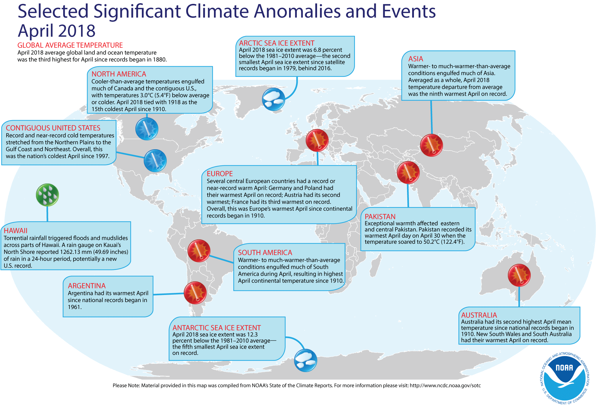
- Global temperatures for April 2018 reviewed -- Using preliminary data collected from the global network of surface weather stations, scientists at NOAA's National Centers for Environmental Information (NCEI) report that the combined global land and ocean surface temperature for April 2018 was the third highest for any April since comprehensive global climate records began in 1880; this April 2018 temperature was 1.49 Fahrenheit degrees above the 20th-century (1901-2000) average. The largest positive ocean-land temperature departure for any April in the 1880-2018 record was set two years ago (April 2016 had a positive 1.94-Fahrenheit degree departure), which was followed by the second largest April departure last year (with a 1.60-Fahrenheit degree positive departure).
The scientists also reported that when considered separately, the April 2018 average temperature over the oceans was 1.17 Fahrenheit degrees above the 20th-century average, representing the fourth highest April global ocean temperature departure in the 139-year record, while the month's average temperature over the land surfaces was 2.36 Fahrenheit degrees above the long-term average, or the ninth highest April land temperature departure on record.
According to data from the Rutgers Global Snow Lab, the Northern Hemisphere snow cover extent for April 2018 was the tenth largest in the 52-year period of record.
According to the National Snow & Ice Data Center, April sea ice extent data for the Arctic Ocean in 2018 was the second smallest April extent since satellite records began in 1979. The smallest April Arctic sea ice extent on record occurred during the last two years (April of 2016 and 2017). The sea ice on waters around Antarctica were the fifth smallest in the satellite era.
A global map of Selected Significant Climate Anomalies and Events for April 2018 is available from NCEI.
[NOAA/NCEI
State of the Climate]
- Satellite provides an eyeful of West Coast swirls -- Images obtained from the MODIS sensor onboard NASA's Terra satellite at the start of last week shows a panoramic view of the West Coast of the U.S. with several swirls or vortices of various sizes in both the marine layer clouds and the offshore waters of the North Pacific. Several vortices are noticeable in the bright white stratiform cloud layer that stretched along the northern California and southern Oregon coasts. These cloud vortices may be caused by air circulating around the headlands that are part of Oregon's Cape Blanco and California's Cape Mendocino. In the cloud-free area farther north, multi-colored swirls in the coastal waters off Washington and northern Oregon are associated with the sediments flowing out of the mouth of the Columbia River and from some phytoplankton bloom. [NASA Earth Observatory]
- Land ice meets sea ice off Greenland -- Photographs made by a sea ice scientist from NASA's Goddard Space Flight Center show land ice, in the form of icebergs, trapped in the sea ice off the coast of Greenland nearly one month ago. This scientist took these photographs from a NASA's P-3 research aircraft as she was participating in NASA's multi-year Operation IceBridge, which monitors polar ice. [NASA Earth Observatory]
- Major shifts in global freshwater detected from satellites -- A team of researchers at NASA's Goddard Space Flight Center and the Jet Propulsion Laboratory analyzed 14 years of observations from the U.S./German-led Gravity Recovery and Climate Experiment (GRACE) spacecraft mission to track global trends in freshwater in 34 regions around the world. In addition, they also used data from the University of Maryland's Global Precipitation Climatology Project and images from the NASA/U.S. Geological Survey Landsat satellite. Freshwater is found in lakes, rivers, soil, snow, groundwater and ice. The team found that between 2002 and 2016, Earth's wet land areas are getting wetter and dry areas are becoming drier due to a variety of factors, including human water management, climate change and natural cycles. [NASA Press Release]
- An All-Hazards Monitor -- This Web portal provides the user information from NOAA's National Weather Service, FAA and FEMA on
current environmental events that may pose as hazards such as tropical
weather, fire weather, marine weather, severe weather, drought and
floods. [NOAA/NWS Daily Briefing]
- Earthweek -- Diary of the Planet [earthweek.com]
Historical Events:
- 22 May 1819...The steamship SS Savannah left Savannah, GA on a voyage to Liverpool, England and became the
first steamship to cross the Atlantic Ocean. It reached Liverpool on 20
June. (Wikipedia)
- 22 May 1849...The future President, Abraham Lincoln,
received a patent for the floating dry dock described as for "buoying
boats over shoals" (No. 6,469). He was the first American president to
receive a patent. His idea utilized inflated cylinders to float
grounded vessels through shallow water. (Today in Science History)
- 22-24 May 1948...A rare early season hurricane struck the
island of Hispaniola, killing an estimated 80 people. (The Weather
Doctor)
- 22 May 1960...A 8.6 magnitude earthquake off the coast of
south central Chile triggered a tsunami that moved across the Pacific
Ocean. Between 490 and 2290 people were estimated to have been killed
by the earthquake and tsunami, and damage estimates were over one half
billion dollars. Hilo, HI was devastated by the tsunami, where 61 fatalities were reported. The
University of Washington)
- 23 May 1850...The US Navy sent USS Advance and USS Rescue to attempt rescue of Sir John
Franklin's expedition, lost in Arctic. (Naval Historical Center)
- 23 May 1946...Commodore Edward M. Webster, USCG, headed the
U.S. Delegation to the International Meeting on Radio Aids to Marine
Navigation, which was held in London, England. As a result of this
meeting, the principal maritime nations of the world would make an
intensive study of the World War II-developed devices of radar, LORAN,
radar beacons, and other navigational aids with a view to adapt them to
peacetime use. This meeting was the first time that the wartime
technical secrets of radar and LORAN were generally disclosed to the
public. (USCG Historian's Office)
- 23 May 1960...Tsunami waves from Chilean earthquakes the previous day began
to affect the Alaska's coast along the Gulf of Alaska from Prince of
Wales Island to Montague Island for as long as one week. The tsunami
waves on the 23rd were up to 14 feet high near Yakutat. (Accord's
Weather Guide Calendar) The tsunami killed killed 61 people in Hilo, HI. An additional 180 people were killed in on the islands of Honshu and Hokkaido in Japan. (National Weather Service files)
- 23 May 2010...A rare tropical cyclone dubbed Bandu brought high winds and heavy rains to Somalia. The storm then moved into the Gulf of Aden where it quickly weakened and dissipated on the 23rd as it passed between Yemen and Somalia. (National Weather Service files)
- 24 May 1500...The 13 ships in the fleet of Portuguese
navigator Pedro Alvares Cabral were hit by a huge ice storm that sank
four ships. The rest of the ships were separated as they sailed south
of the Cape of Good Hope and continued their journey to India.
- 24 May 1901...The relative humidity at Parkstone, Dorset in
England at 4 PM was reported to be 9.5 percent. This low relative
humidity is not typical of the British Islands, which are surrounded by
ocean water and have no large high mountain barriers or plateaus.
(Accord's Weather Guide Calendar)
- 24 May 1951...Northeast gales generated waves to 15 feet
high in the harbor of Newport, RI. A 50-ft. Navy launch with about 142
men on board capsized. Nineteen of the men drowned in the incident.
(Accord's Weather Guide Calendar)
- 24 May 1992...Winds up to 40 knots and seas to 18 feet in
the northern Gulf of Alaska, approximately 30 miles southwest of
Alaska's Cape Cleare, sent three waves crashing over the Cajun
Mama. The 80-ft fishing boat sank, but the crew of five was
rescued. (Accord's Weather Guide Calendar)
- 25 May 1953...In 1953, tropical storms began being named after women. Tropical Storm Alice, which formed near Nicaragua on this date, was the first Atlantic cyclone to be named in this way. (National Weather Service files)
- 25 May 1985...The Meghna River delta in Bangladesh was hit
with a tropical cyclone with winds of over 100 mph that created a 15-to
20-foot high storm surge that flooded a 400-square-mile area, mainly
islands located in the mouth of the river. More than 11,000 people and
500,000 head of cattle died and hundreds of thousands were left
homeless because of this cyclone.
- 26 May 1967...A slow moving nor'easter battered New England
with high winds, heavy rain, and record late season snow on this day
and into the 26th. Winds 70 to 90 mph in gusts occurred along the
coast. Over 7 inches of rain fell at Nantucket, MA with 6.57 inches
falling in 24 hours to set a new 24-hour rainfall record. Severe damage
occurred along the coast from very high tides. The 24.9 inches of snow
that fell at Mount Washington, NH set a new May snowfall record. Other
locations in New Hampshire received 10 inches of snow near Keene and 6
inches at Dublin. (Intellicast)
- 27 May 1774...Sir Francis Beaufort, inventor of the Beaufort Wind Scale, was born in County Meath, Ireland. (National Weather Service files)
- 28 May 1963...A tropical cyclone struck Bangladesh (formerly East Pakistan) killing 11,500 people along
the coast. (National Weather Service files)
Return to RealTime Ocean Portal
Prepared by AMS Ocean Central Staff and Edward J. Hopkins,
Ph.D.,
email hopkins@aos.wisc.edu
© Copyright, 2018, The American Meteorological Society.