For more than a century, meteorologists have measured the near-surface atmospheric humidity (water vapor content) using various instruments including hair hygrometers, sling psychrometers, and dewpoint hygrometers. However, those relative humidity, wet-bulb and dewpoint readings reflect humidity measurements only within the lowest several meters of Earth's atmosphere.
Observations of the atmospheric humidity, along with air temperature and air pressure, are difficult to obtain in the free atmosphere, which extends upward to tens of kilometers above Earth's surface. Meteorologists need to sample the atmosphere at various levels and construct a sounding, a plot of the vertical variations of observed weather elements above a station.
During the 19th century some in situ measurements of atmospheric properties, including humidity, were made by instruments carried on manned balloon ascents. An in situ measurement is one where the instrument is immersed in the environment that is being measured. At the end of that century, the predecessor to the National Weather Service began conducting upper air kite observations. Recording instruments were attached to box kites, but could only be read once the kite was reeled back to the ground. Kite observations, along with subsequent airplane observations made in the early 1930s were too limited in terms of altitudes attained, too time consuming, and too costly.
Since about 1936, routine upper-air observations have been made using relatively small, inexpensive, and expendable instruments carried to altitudes of approximately 30,000 m (100,000 ft) by inflated balloons. Small electronic sensors make a nearly continuous measurement of the atmospheric temperature and humidity on the ascent, while an aneroid barometer measures the air pressure. A FM radio transmitter within the instrument package transmits the collected temperature, humidity, and air pressure readings back to Earth's surface for processing. The entire instrument package is called a radiosonde, a term that apparently was derived from a combination of the words "radio" for the onboard radio transmitter and "sonde," which is an old English word for messenger. Wind speed and direction are determined at various levels in the atmosphere during the ascent of the radiosonde by using a ground-based radio direction-finding antenna that tracks the motion of the balloon. More recent versions of this instrument use a global positioning system (GPS) for tracking purposes. Together the radiosonde data and wind information constitute a rawinsonde observation.
Currently, about 70 radiosonde stations are distributed across the continental United States. Radiosondes are launched from these stations twice daily, just prior to 0000 UTC and 1200 UTC. The upper-air data collected from each of these stations are transmitted worldwide over standard communications networks to a centralized location for use in a variety of upper air charts and numerical weather prediction models.
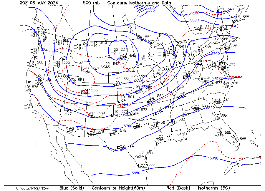
One such upper air chart that appears on the DataStreme WES Website is the 500-mb chart. Such a chart is a nationwide display of the upper atmospheric conditions at a level where radiosondes report a pressure of 500 millibars (mb). These charts portray conditions at an average altitude of roughly 5500 m (18,000 ft) above sea level--slightly higher where the air column is relatively warm and slightly lower in a relatively cold air column. Whereas some of the specifics of the upper air station model differ from those of the surface station model, temperature is plotted in degrees Celsius at roughly the 10 o'clock position and the dewpoint is plotted in degrees Celsius at roughly the 8 o'clock position. A specimen upper air station model appears in the highlighted Map Symbol Explanation entry on the DataStreme WES Website.
These 500 mb charts can be used to check the atmospheric humidity in the middle troposphere at an altitude of approximately 5500 m. Typically, when the 500-mb dewpoints are within 5 Celsius degrees of the reported 500 mb air temperatures we can assume relatively humid conditions at that level and a possible cloud deck.
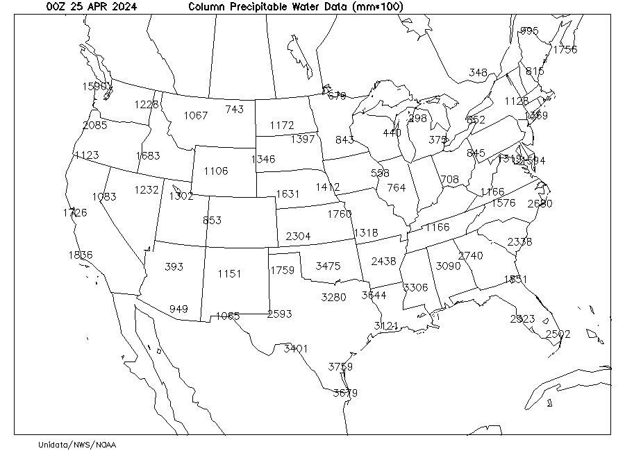
Precipitable water is a measure of the total water vapor content in an atmospheric column extending upward from Earth's surface. Specifically, the precipitable water is the depth of liquid water that would be collected if all the water vapor in a column of air of unit area, say one square centimeter, were condensed. Computer programs calculate the precipitable water from the vertical dewpoint profile obtained from each radiosonde ascent. A current Precipitable Water chart is available on the DataStreme WES Website. The precipitable water data obtained by individual radiosondes are plotted in hundredths of a millimeter (mm) at the location of the reporting station. For example, a value of 220 plotted on the map indicates 2.20 mm of precipitable water in the atmospheric column above that station.
Unlike the in-situ humidity observations obtained at surface weather observation sites and onboard radiosondes, environmental satellites are currently using remote sensing techniques to measure atmospheric humidity from above Earth's atmosphere. Two techniques are used, that is, a scanning mode and a sounder mode.
We are familiar with the satellite images that appear on television or on the DataStreme WES Website. These images are produced when geosynchronous satellites operate in what is known as a "scanning mode." Some instruments onboard the satellite that are sensitive to the infrared and water vapor channels collect the long-wave (IR) radiation emanating from various components of the Earth's system, including clouds, the atmosphere, or Earth's surface. (The instruments sensing the water vapor channel are tuned to a slightly different portion of the electromagnetic spectrum than those that produce the traditional infrared thermal imagery.) These sensors sweep across the field of view, in a scanning pattern. The data are transmitted to Earth receiving stations where satellite images are produced. One of the satellite imagery products that we can use to estimate the atmospheric humidity above Earth's surface is the current Water Vapor (WV) Satellite image on the DataStreme WES Website. As described elsewhere, water vapor sensors detect atmospheric water vapor and cloud particles (both droplets and ice crystals) at altitudes on the order of 4000 to 6000 m, which is near the level depicted by the 500-mb chart. Areas appearing white on the water vapor image are the most humid and are often indicative of rising air motion. On the other hand, dark regions indicate relatively dry conditions and sinking air motion. A series of water vapor images appearing as a loop in the Latest WV Animation on the DataStreme WES Website helps meteorologists see the mid-tropospheric flow patterns.
The other technique used to determine atmospheric water vapor concentration remotely using a satellite-based instrument operates in the "sounder mode." In this technique, a special sensor samples the infrared radiation reaching the satellite from a small region in the sensor's field of view, looking at emitted radiation over small wavelength intervals. The intensity of the long-wave radiation emitted by water vapor in certain regions of the spectrum depends to a certain extent upon the pressure, which ultimately identifies the level in the atmosphere. By using this technique, the sensor operates as a sounder, retrieving temperature or humidity information from various levels in the atmosphere above one location on Earth. By sampling at many locations, the sounder onboard the satellite can determine the amount of precipitable water in the atmosphere across a broad region.
For more information on the operation of satellite soundings, go to
http://cimss.ssec.wisc.edu/goes/sounder_tutorial/g8.html
.
Also, the latest precipitable water image of the continental US from the GOES
satellites is at
http://www.orbit.nesdis.noaa.gov/smcd/opdb/goes/soundings/html/tpwus.html.
If you inspect this image, you soon realize that this sounding method from
satellites cannot currently provide precipitable water information in those
locations with cloud cover.
Return to DataStreme WES website
Prepared by WES Central Staff and Edward J. Hopkins, Ph.D., email
hopkins@meteor.wisc.edu
© Copyright, 2008, The American Meteorological Society.