WEEKLY CLIMATE NEWS
21-25 May 2018
ITEMS
OF INTEREST
- Reviewing historical highlights of the U.S. climate record -- The chief of the dataset branch in the Center for Weather and Climate at NOAA's National Centers for Environmental Information (NCEI) posted a blog on the "Beyond the Data" site providing historical insight into the development of the nation's climate record. He describes the early weather observers who were responsible for initiating the more than 150 years of weather data collected across the United States and now archived at NCEI. He provides a copy of the entries made into a weather log book in 1776 by Thomas Jefferson, who became the third President of the U.S. Attention was also given to the weather observers who were part of organizations that were predecessors to the current National Weather Service, including the U.S. Army's Medical Corps and Signal Service, and the U.S. Weather Bureau. The Smithsonian Institution's network of volunteer observers in the mid-19th century is also mentioned, along with the current Cooperative Observer Program (COOP) that began in 1890. [NOAA Climate.gov News]
- North American Safe Boating Week -- The 2018 National Safe Boating Week will continue through Friday, 25 May. This week helps launch the 2018 North American Safe Boating Campaign. Check the Safe Boating Week site maintained by the Safe Boating Council. Several states, primarily in New England will be conducting their own state Safe Boating and Beach Safety Weeks. California will have Safe Boating Cold Water Awareness Week.
- Climatology of Indy 500 Race Day-- Next Sunday, 27 May 2018, is the scheduled running of the 102st Indianapolis 500-Mile Race. The Indianapolis Forecast Office of the National Weather Service has a list of the pertinent weather and climate statistics for race day, including the average high and low temperatures, rainfall and wind for the 1911-2017 period and a listing of the top 20 temperature, precipitation and wind extremes for the previous races.
CURRENT CLIMATE STATUS
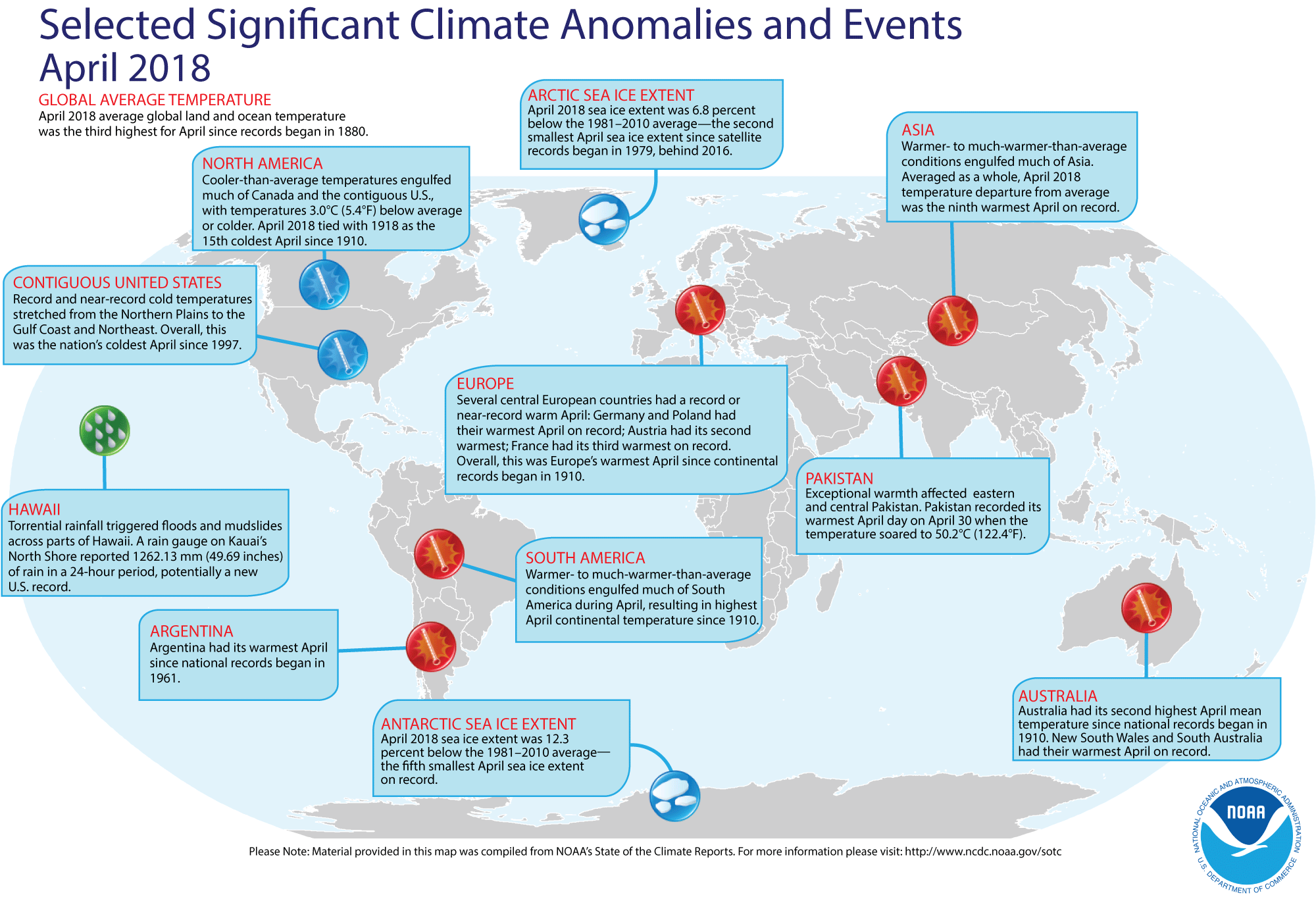
- National weather and climate reviewed for April 2018 -- Scientists at the NOAA National Centers for Environmental Information (NCEI) reported that their analysis of preliminary data indicates the April 2018 monthly average temperature for the 48 coterminous states was 2.2 Fahrenheit degrees below the 20th-century (1901-2000) average, which made this past month the thirteenth coldest April since 1895 when comprehensive climate records became available nationwide. In addition, last month was the coldest April since 1997. Furthermore, the nationwide maximum or daytime temperature was 1.7 Fahrenheit degrees below the long-term average (or 21st lowest on record), while the nationwide minimum or nighttime temperature was 2.6 Fahrenheit degrees below average (or seventh lowest since 1895).
The majority of the 48 contiguous states (37) reported below to much below average April statewide average temperatures this past month, with twenty-two states in the Mississippi Valley and Great Lakes experiencing statewide temperatures that ranked within the ten lowest on record for their respective states. Iowa and Wisconsin recorded their lowest April statewide temperatures on record, while eight neighboring states had their second lowest April average temperatures in the last 124 years. On the other hand, six states across the West reported above to much above average statewide temperatures for April. Arizona had its second highest April statewide average temperature on record.
Alaska experienced its 26th warmest April since sufficiently dense weather records began in what became the 49th State in 1925.
Monthly precipitation across the lower 48 states for April 2018 was approximately 0.11 inches below the 20th-century monthly average, which made this month the 53rd driest April on record. Thirteen of the states across the nation's midsection, running from the Upper Midwest and northern Plains southward to the western Gulf Coast and westward to the Four Corners States (Arizona, Colorado, New Mexico and Utah) reported below to much below average statewide April precipitation. Arizona, New Mexico, Kansas and Missouri experienced statewide April precipitation totals that ranked within the ten lowest in 124 years. Conversely, five western states and seventeen states to the east of the Mississippi River reported above to much above average statewide precipitation totals for this past month. The state of Washington had its third wettest April since 1895.
Alaska had its 33rd wettest April in 94 years. [NOAA News] or
[NOAA/NCEI State of the Climate]
NOTE: A description is provided of the climatological rankings employed by NCEI for their monthly and seasonal maps. [NOAA/NCEI]
- April national drought report -- The National
Centers for Environmental Information has posted its April
2018 drought report online. Using the Palmer Drought Severity
Index, approximately fifteen percent of the contiguous United States
experienced severe to extreme drought conditions at the end of
April, while six percent of the area had severely to extremely wet
conditions.
- Global temperatures for April 2018 reviewed -- Using preliminary data collected from the global network of surface weather stations, scientists at NOAA's National Centers for Environmental Information (NCEI) report that the combined global land and ocean surface temperature for April 2018 was the third highest for any April since comprehensive global climate records began in 1880; this April 2018 temperature was 1.49 Fahrenheit degrees above the 20th-century (1901-2000) average. The largest positive ocean-land temperature departure for any April in the 1880-2018 record was set two years ago (April 2016 had a positive 1.94-Fahrenheit degree departure), which was followed by the second largest April departure last year (with a 1.60-Fahrenheit degree positive departure).
The scientists also reported that when considered separately, the April 2018 average temperature over the oceans was 1.17 Fahrenheit degrees above the 20th-century average, representing the fourth highest April global ocean temperature departure in the 139-year record, while the month's average temperature over the land surfaces was 2.36 Fahrenheit degrees above the long-term average, or the ninth highest April land temperature departure on record.
According to data from the Rutgers Global Snow Lab, the Northern Hemisphere snow cover extent for April 2018 was the tenth largest in the 52-year period of record.
According to the National Snow & Ice Data Center, April sea ice extent data for the Arctic Ocean in 2018 was the second smallest April extent since satellite records began in 1979. The smallest April Arctic sea ice extent on record occurred during the last two years (April of 2016 and 2017). The sea ice on waters around Antarctica were the fifth smallest in the satellite era.
A global map of Selected Significant Climate Anomalies and Events for April 2018 is available from NCEI.
[NOAA/NCEI
State of the Climate]
CURRENT
CLIMATE MONITORING
- Major shifts in global freshwater detected from satellites -- A team of researchers at NASA's Goddard Space Flight Center and the Jet Propulsion Laboratory analyzed 14 years of observations from the U.S./German-led Gravity Recovery and Climate Experiment (GRACE) spacecraft mission to track global trends in freshwater in 34 regions around the world. In addition, they also used data from the University of Maryland's Global Precipitation Climatology Project and images from the NASA/U.S. Geological Survey Landsat satellite. Freshwater is found in lakes, rivers, soil, snow, groundwater and ice. The team found that between 2002 and 2016, Earth's wet land areas are getting wetter and dry areas are becoming drier due to a variety of factors, including human water management, climate change and natural cycles. [NASA Press Release]
- Evaluation of possible new record Antarctic temperature is concluded -- Earlier this month, the World Meteorological Organization (WMO) Commission for Climatology's Archive of Weather and Climate Extremes finished its evaluation of the highest temperature recorded in the Antarctic continent. An automatic weather station established by the Czech Republic on Davies Dome near the northern tip of the Antarctic Peninsula had recorded a temperature of 17.9 degrees Celsius (64.2 degrees Fahrenheit). However, the WMO committee concluded that this temperature be readjusted downward to 17°C (62.6°F). Consequently, the existing high temperature record for the Antarctic continent of 17.5°C (63.5°F) recorded on 24 March 2015 at the Argentine Research Base Esperanza on the northern Antarctic Peninsula was upheld. [World Meteorological Organization News]
- Land ice meets sea ice off Greenland -- Photographs made by a sea ice scientist from NASA's Goddard Space Flight Center show land ice, in the form of icebergs, trapped in the sea ice off the coast of Greenland nearly one month ago. This scientist took these photographs from a NASA’s P-3 research aircraft as she was participating in NASA's multi-year Operation IceBridge, which monitors polar ice. [NASA Earth Observatory]
- Wind and solar powered saildrones are collecting environmental data in remote oceanic areas -- Saildrones, which are autonomous ocean-going sailing drones resembling bright orange colored surfboards, have been deployed by NOAA and its partner Saildrone Inc. to collect ecologic, oceanic, and atmospheric data from remote areas of the world oceans. These 20-foot tall saildrones are propelled by the wind as they carry over 200 pounds of instruments that are powered by solar collectors. The data collected by the drone's sensors are related by satellite to land-based operators. Some of the data-collecting missions have been to the Bering and Chukchi Seas offshore of Alaska and to the eastern tropical Pacific from California. [NOAA Climate.gov News]
The engineer who developed these drones and CEO of Saildrone Inc., Richard Jenkins, was recently interviewed on his aim to build thousands of the drones. [Bloomberg Businessweek]
CLIMATE FORCING
- Hawaii's Kilauea Volcano erupts -- During the past week, the Kilauea Volcano on Hawaii's Big Island erupted explosively, sending a plume of ash and gases upward into the atmosphere to an altitude of approximately 30,000 feet. The National Weather Service issued its first-ever ashfall advisory for Hawaii. Since volcanic activity is continuing, the National Weather Service (NWS) and the U.S. Geological Survey (USGS) are providing links to various websites that provide updates on daily activity. [NOAA/NWS Weather-Ready Nation] and [USGS News]
- Gulf of Mexico Loop Current affected by the West Florida Shelf and Dry Tortugas -- Marine scientists at the University of South Florida are attempting to explain the behavior of the Loop Current that intrudes into the Gulf of Mexico. This Loop Current is a warm water current that flows northward from the western Caribbean through the Yucatan Channel and into the Gulf of Mexico where it loops east and then south before exiting to the east through the Florida Straits. Using more than 24 years of satellite altimetry-derived sea surface height data, the researchers found that anomalous northward penetrations of the Loop Current into the Gulf of Mexico occur when the eastern side of Loop Current is positioned west from the southwest corner of the west Florida continental shelf near the Dry Tortugas, while the more direct inflow to outflow route occurs when the eastern side of the Loop Current encounters the southwest corner of the West Florida Shelf. [NOAA National Centers for Coastal Ocean Science News]
CLIMATE FORECASTS
- New Seasonal Climate Outlooks for this summer
issued -- Near the end of last week, forecasters at the NOAA
Climate Prediction Center (CPC) released their new national Three-Month
(Seasonal) Climate Outlooks for the upcoming summer season. These three
months, running from June through August 2018, are identified as
meteorological summer for the Northern Hemisphere. Specific details of
their outlooks include:
- Temperature and precipitation outlooks -- According to their temperature
outlook, slightly more than three-quarters of the 48 contiguous United States should experience a high chance of above average temperatures for these three upcoming months, with the greatest probability of such an occurrence being across the Southwest, centered upon Nevada and the Four Corners States of Arizona, Colorado, New Mexico and Utah. Maine in northern New England was also given a good chance of having above average summer temperatures. Nearly equal chances of warmer or cooler than normal conditions were anticipated in the north-central sections of the nation, running eastward from the Plains of eastern Montana to Michigan in the western Great Lakes and southward from the U.S. Canadian border to the confluence of the Ohio and Mississippi Rivers.
Their precipitation outlook calls for better than even chances of wet conditions for summer 2018 across most of the nation to the east of the Mississippi River, with the highest probabilities of wet weather being centered along the Appalachians. Above average precipitation was possible over western Colorado and eastern Utah.
Conversely, Washington, Oregon and Idaho in the Northwest have better than even chances of experiencing a drier than below average summer. The rest of the contiguous states should have equal chances of below and above average summer precipitation.
Outlooks for June are also available. A summary
of the prognostic discussion of the outlook for non-technical
users is available from CPC. These forecasts were based in part on ENSO-neutral conditions prevailing during this upcoming meteorological summer, with the possibility of El Niño conditions developing across the equatorial Pacific during the transition into autumn and early winter in the Northern
Hemisphere.
- Seasonal Drought Outlook released -- The forecasters at NOAA's Climate Prediction Center also released their US
Seasonal Drought Outlook last week that would run from mid-May through August 2018. Their outlook shows that sections of the Southwest centered on the Four Corners (Arizona, Colorado, New Mexico and Utah) currently experiencing severe to exceptional drought should continue to have drought conditions through this summer. Regions of the interior Northwest (Oregon) and the northern Plains (North Dakota, northern Minnesota and eastern Montana) should also continue to have drought. Large sections of southern and central Texas should see an expansion of the drought, while farther to the north, the Texas Panhandle along with other sections of the Plains extending northward across Oklahoma and Kansas could see some improvement in the drought. Some sections of Missouri, Iowa and South Dakota could be removed from drought status. Scattered areas of the Southeast could also see elimination of the drought by end of summer. Note: a Seasonal
Drought Outlook Discussion is included describing the
forecasters' confidence.
CLIMATE
AND HUMAN HEALTH
- Indoor air quality in health care facilities is maintained despite wildfires and smoke -- An article originally published for the U.S. Climate Resilience Toolkit provides several examples of the measures taken during the last several years by hospitals and other health care facilities across the West to maintain indoor air quality despite smoke from nearby wildfires. With proper monitoring and preparations, these health care facilities remained open to patients and staff. [NOAA Climate.gov News]
- Pollution from personal care products rival vehicular tailpipe emissions in Boulder, CO -- Scientists from NOAA's Earth System Research Laboratory, the Cooperative Institute for Research in Environmental Sciences, Environment and Climate Change Canada and the University of South Carolina recently reported on the diurnal variability and emission patterns of a volatile organic chemical compound from the application of personal care products in Boulder, CO and in Toronto, ON. The researchers found that during the morning rush hour in Boulder, the trail of chemical vapors emitted by personal care products that commuters use on their skin and hair are comparable in magnitude to the emissions of major components of vehicle exhaust. [NOAA Research News]
CLIMATE AND SOCIETY
- Online U.S. wind turbine database is now available -- The U.S. Geological Survey (USGS), the U.S. Department of Energy's Lawrence Berkeley National Laboratory and the American Wind Energy Association recently unveiled its United States Wind Turbine Database (USWTDB) along with the USWTDB Viewer that permits access to this new public dataset. Currently, USWTDB has the wind turbine locations and characteristics for more than 57,000 wind turbines in 43 states plus Puerto Rico and Guam. [USGS News]
- Earthweek -- Diary of the Planet [earthweek.com]
Historical Events:
- 21 May 1895...The temperature at Norwalk, OH dipped to 19
degrees to set a state record for the month of May. (The Weather
Channel)
- 21 May 1896...The mercury soared to 124 degrees at Salton,
CA to establish an U.S. record for May. (Sandra and TI Richard Sanders
- 1987)
- 21 May 1980...The temperature at Williston, ND reached 102
degrees to set a record for May, and the next day the mercury hit 106
degrees. (The Weather Channel)
- 22 May 1876...Denver, CO was drenched with 6.53 inches of
rain in 24 hours, an all-time record for that location. (The Weather
Channel)
- 22 May 1911...The temperature at Lewiston, ME soared to 101
degrees, the highest temperature ever recorded in New England during
the month of May. (David Ludlum)
- 22 May 1922...The United Kingdom recorded its hottest May
day on record when the thermometer hit 91 degrees at Camden Square,
London, England. (The Weather Doctor)
- 22 May 1980...The temperature at Winnipeg, Manitoba rose to
98.6 degrees, setting a record high for May. (The Weather Doctor)
- 23 May 1953...The temperature at Hollis, OK soared from a
morning low of 70 degrees to an afternoon high of 110 degrees, to
establish a state record for the month of May. (The Weather Channel)
- 24 May 2002...The last measurable snow for the season fell at Marquette, Michigan. This brought the city's seasonal snowfall to 319.8 inches, by far the city's snowiest winter ever. (National Weather Service files)
- 26 May 1967...A slow moving nor'easter battered New England
with high winds, heavy rain, and record late season snow on this day
and into the 26th. Over 7 inches of rain fell at Nantucket, MA with
6.57 inches falling in 24 hours to set a new 24-hour rainfall record.
The 24.9 inches of snow that fell at Mount Washington, NH set a new May
snowfall record. Other locations in New Hampshire received 10 inches of
snow near Keene and 6 inches at Dublin. (Intellicast)
- 26 May 2001...The 2000-2001 snowfall season finally ended
in St John's, Newfoundland, during which time a grand total of 255.3
inches of snow fell. The total snow, which broke a century-old mark,
was estimated to have weighed 500 million tons! (The Weather Doctor)
- 27 May 1948...The 1.5 inches of rainfall at Victoria,
British Columbia set the record for the wettest May day observed in the
provincial capital city. (The Weather Doctor)
Return to RealTime Climate Portal
Prepared by Edward J. Hopkins, Ph.D., email hopkins@aos.wisc.edu
© Copyright, 2018, The American Meteorological Society.